McKittrick, Missouri facts for kids
Quick facts for kids
McKittrick, Missouri
|
|
|---|---|

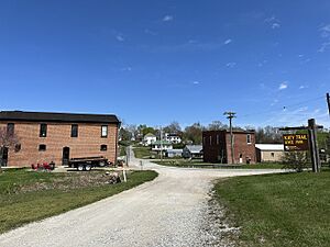
McKittrick in 2024
|
|

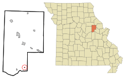
Location in Montgomery County and the state of Missouri
|
|
| Country | United States |
| State | Missouri |
| County | Montgomery |
| Area | |
| • Total | 0.49 sq mi (1.26 km2) |
| • Land | 0.49 sq mi (1.26 km2) |
| • Water | 0.00 sq mi (0.00 km2) |
| Elevation | 558 ft (170 m) |
| Population
(2020)
|
|
| • Total | 77 |
| • Density | 157.79/sq mi (60.92/km2) |
| Time zone | UTC-6 (Central (CST)) |
| • Summer (DST) | UTC-5 (CDT) |
| ZIP Code |
65041
|
| FIPS code | 29-45200 |
| GNIS feature ID | 2396745 |
McKittrick is a small city located in Montgomery County, Missouri, in the United States. In 2020, about 77 people lived there. It's a quiet place with a rich history.
Contents
History of McKittrick
McKittrick was officially started in 1895. This happened when a railroad line was built through the area. Before the city was even laid out, a post office opened in McKittrick in 1894. This post office served the community for many years, finally closing in 1967.
A very important building in the city, the McKittrick Farmers Mercantile, was added to the National Register of Historic Places in 2010. This means it's recognized as a special place that helps tell the story of the area.
Geography and Location
McKittrick is found in the southeastern part of Montgomery County. A main road, Missouri Route 19, runs along the west side of the city. If you travel south on Route 19 for about 2 miles (3.2 km), you will cross the Missouri River and reach the larger city of Hermann. McKittrick and Hermann even share the same ZIP Code. If you go north on Route 19 for about 15 miles (24 km), you'll arrive at New Florence.
The city covers a total area of about 0.49 square miles (1.26 square kilometers), and all of it is land. The Loutre River, which is a smaller river that flows into the Missouri River, forms the western edge of McKittrick.
Population and People
McKittrick is a small community. Here's how its population has changed over the years:
| Historical population | |||
|---|---|---|---|
| Census | Pop. | %± | |
| 1910 | 127 | — | |
| 1920 | 111 | −12.6% | |
| 1930 | 151 | 36.0% | |
| 1940 | 124 | −17.9% | |
| 1950 | 100 | −19.4% | |
| 1960 | 97 | −3.0% | |
| 1970 | 101 | 4.1% | |
| 1980 | 87 | −13.9% | |
| 1990 | 66 | −24.1% | |
| 2000 | 72 | 9.1% | |
| 2010 | 61 | −15.3% | |
| 2020 | 77 | 26.2% | |
| U.S. Decennial Census | |||
McKittrick in 2010
Based on the census from 2010, there were 61 people living in McKittrick. These people lived in 28 different homes, and 18 of these were families. The city had about 678 people per square mile (262 people per square kilometer). All the residents counted in 2010 were White.
Out of the 28 homes:
- About 18% had children under 18 living there.
- Half of the homes (50%) were married couples living together.
- A small number (about 4%) had a female head of household with no husband.
- About 11% had a male head of household with no wife.
- About 36% of homes were not families, meaning individuals or roommates.
- About 32% of all homes were people living alone.
- About 14% had someone living alone who was 65 years old or older.
The average number of people in each home was about 2.18, and the average family had about 2.67 people. The average age of people in McKittrick was 44.5 years old. About 20% of residents were under 18, and about 26% were 65 or older. The city had slightly more females (54.1%) than males (45.9%).
See also
 In Spanish: McKittrick (Misuri) para niños
 | John T. Biggers |
 | Thomas Blackshear |
 | Mark Bradford |
 | Beverly Buchanan |

