New Florence, Missouri facts for kids
Quick facts for kids
New Florence, Missouri
|
|
|---|---|

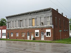
An iron-front store building in New Florence
|
|

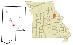
Location in Montgomery County and the state of Missouri
|
|
| Country | United States |
| State | Missouri |
| County | Montgomery |
| Area | |
| • Total | 3.03 sq mi (7.84 km2) |
| • Land | 3.01 sq mi (7.79 km2) |
| • Water | 0.02 sq mi (0.06 km2) |
| Elevation | 863 ft (263 m) |
| Population
(2020)
|
|
| • Total | 641 |
| • Density | 213.17/sq mi (82.29/km2) |
| Time zone | UTC-6 (Central (CST)) |
| • Summer (DST) | UTC-5 (CDT) |
| ZIP code |
63363
|
| Area code(s) | 573 |
| FIPS code | 29-51770 |
| GNIS feature ID | 2395192 |
New Florence is a city located in Montgomery County, Missouri, in the United States. In 2020, about 641 people lived there. This was a decrease from 769 people in 2010.
Contents
History of New Florence
New Florence was first called "Florence." The city was officially planned out in 1858. It was named after Florence Lewis, who was the daughter of one of the first people to settle in the area. A post office has been operating in New Florence since 1858.
Geography of New Florence
New Florence is in the middle of Montgomery County. It is located where two important roads meet: Interstate 70 and Missouri Route 19. Highway 19 goes through the western part of the city. You can get to it from Interstate 70 at Exit 175.
Montgomery City, which is the county seat, is about 5 miles (8 km) northwest. Hermann, another city, is about 16 miles (26 km) to the south.
New Florence is home to a branch of Stone Hill Winery. This area, stretching towards the St. Louis suburbs, is known as the Missouri Rhineland. It became famous for its vineyards in the mid-1800s. Many German immigrants started these vineyards.
According to the U.S. Census Bureau, New Florence covers a total area of about 3.03 square miles (7.84 km²). A very small part of this, about 0.02 square miles (0.06 km²), is water. The city sits on a small ridge. Water from the north side of the ridge flows into Elkhorn Creek. This creek is part of the Cuivre River system, which eventually flows into the Mississippi River. Water from the west side of the ridge flows into Smith Branch. This branch is part of the Loutre River system, which flows into the Missouri River. The southwest part of the city drains into Calhoun Hollow and Clear Creek, which are also part of the Loutre River system.
Population Information
| Historical population | |||
|---|---|---|---|
| Census | Pop. | %± | |
| 1860 | 103 | — | |
| 1870 | 53 | −48.5% | |
| 1880 | 373 | 603.8% | |
| 1890 | 465 | 24.7% | |
| 1900 | 424 | −8.8% | |
| 1910 | 424 | 0.0% | |
| 1920 | 600 | 41.5% | |
| 1930 | 571 | −4.8% | |
| 1940 | 565 | −1.1% | |
| 1950 | 522 | −7.6% | |
| 1960 | 616 | 18.0% | |
| 1970 | 635 | 3.1% | |
| 1980 | 731 | 15.1% | |
| 1990 | 801 | 9.6% | |
| 2000 | 764 | −4.6% | |
| 2010 | 769 | 0.7% | |
| 2020 | 641 | −16.6% | |
| U.S. Decennial Census | |||
2010 Census Details
In 2010, the city had 769 people living in it. There were 257 households and 181 families. The population density was about 263 people per square mile (101 people per km²).
Most of the people in New Florence were White (96.6%). A small number were African American (0.9%), Native American (0.1%), or Asian (0.1%). About 1.8% of the population identified as two or more races. Hispanic or Latino people made up 0.8% of the population.
Out of the 257 households, 35.4% had children under 18 living with them. About 51.4% were married couples living together. About 29.6% of households were not families.
The average age of people in the city was 41 years old. About 24.3% of residents were under 18. About 18.2% were 65 years old or older. The city had slightly more females (50.5%) than males (49.5%).
See also
 In Spanish: New Florence (Misuri) para niños
 | Laphonza Butler |
 | Daisy Bates |
 | Elizabeth Piper Ensley |

