Loutre River (Missouri River) facts for kids
The Loutre River is a 58.4-mile (94.0 km) long river in the United States. It's a branch of the big Missouri River.
The Loutre River starts in Audrain County. It then flows north into the Missouri River in Montgomery County. This is right across from the town of Hermann. The name Loutre means "otter" in French. French trappers gave the river this name a long time ago.
River's Journey
The Loutre River begins in Audrain County, Missouri. It flows until it joins the Missouri River in Warren County, Missouri.
- Mouth (where it ends): Confluence with the Missouri River in Warren County, Missouri: 38°42′43″N 91°25′03″W / 38.71199°N 91.41738°W
- Source (where it starts): Audrain County, Missouri: 39°05′27″N 91°47′28″W / 39.09087°N 91.79100°W
A Look Back in Time
The Loutre River has a very long and interesting history. It was like a highway for Native Americans and early European and American settlers. They used it for travel and trading in early Montgomery County.
Ancient History at Graham Cave
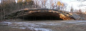
People have lived near the Loutre River for over 10,000 years! The river flows through Graham Cave State Park in Montgomery County. Graham Cave is a famous cave located right above the river.
When archaeologists explored the cave from 1949 to 1955, they found amazing things. They discovered proof of ancient Dalton and Archaic Period Native Americans. Inside the cave, there was even an old ceremonial spot that dates back to 8000 B.C.E. (Before Common Era). This discovery helped historians learn more about early human life in North America.
Early Settlements and Famous Visitors
The first Europeans to settle in Montgomery County arrived on Loutre Island around 1798. At that time, the area was controlled by Spain. French trappers and voyageurs (French-Canadian travelers) were the first to find the island.
Loutre Lick was another very early settlement, started between 1808 and 1810. It got its name because it was near a salt lick by the river. A salt lick is a place where animals go to lick salt from the ground. This settlement was also called Van Bibbers Lick, named after Major Isaac Van Bibber. He moved there from Kentucky in 1800 and tried to build a hotel and other buildings. Today, the town of Mineola, Missouri is located where Loutre Lick used to be.
Loutre Lick was also known as a health resort because of its mineral springs. Even famous people like Daniel Boone and Thomas Hart Benton visited the springs hoping to feel better.
Conflicts and Forts
In the early 1800s, there were conflicts between Native Americans and the settlers moving into the area. To protect the American settlers, the Army built Fort Clemson on Loutre Island. This fort was a base for soldiers.
Washington Irving's Visit
Around 1832, the famous author Washington Irving visited Montgomery County. He was on his way to the western parts of the country. He stayed for about a day at Loutre Lick and enjoyed exploring the beautiful hills nearby. He even told Major Van Bibber that he would build a nice home there if he ever became rich!
Natural Springs and Earthquakes
Many natural springs used to flow in the area, especially along the riverbanks near Mineola. While most of the springs that were used for business in the 1800s have stopped flowing, some can still be found. It is believed that many of these springs appeared after the powerful New Madrid earthquake in 1812.
German Heritage and Communities
The Loutre Island area is closely linked to German towns like Rhineland and Starkenburg. These towns have important Catholic churches and sites, including the Shrine of Our Lady of Sorrows. These communities were founded by German settlers who came from Hermann in the mid-19th century. They also started vineyards in this area.
Loutre Island Cemetery
About a mile north of McKittrick, you can find the Loutre Island Cemetery. This cemetery has about 180 graves and was used by African-American communities from 1804 to around 1954. It was called Loutre Island Cemetery because it was on an actual island in the Loutre River when it started. The river was much wider back then.
African-American History
In the early to mid-1800s, slavery was common in Montgomery County. The lowlands near the Loutre River were used to grow crops like hemp and tobacco, mostly with the help of enslaved people. An African-American settlement called Little Africa was founded around 1800. It was on one of the highest points in the county, overlooking the Loutre River near McKittrick.
The German settlement of Hermann, across the Missouri River, strongly opposed slavery. This created a big difference in beliefs across the river. Hermann became a safe place for enslaved people who had escaped. Many of them settled in Little Africa near the Loutre River.
The Loutre River Today
The Loutre River is still an important part of the area today.
Protecting the River
In 2000, a hog farm accidentally released pig waste into the Loutre River. This caused a lot of fish to die. The company was fined a large amount of money to help fix the damage to the environment. This event showed how important it is to protect our rivers from pollution.
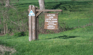
The Missouri Department of Conservation takes care of the Loutre Lick Public Fishing Access. This is a great place for fishing, hunting, and trapping. You can find bass, catfish, sunfish, and crappie in the river here. The area also has forests and fields, which are good for hunting deer, turkey, and other animals.
Graham Cave State Park also has a paved boat access to the river. It's free for park visitors and has a large parking area, picnic tables, and barbecue grills. The park also has the Loutre River trail, which is a hiking and mountain biking path that runs next to the river for about half a mile.
Special Fish Species
The Loutre River is one of the only places in Missouri where you can still find a rare fish called the blacknose shiner. If you see blacknose shiner fish, it means the water quality is very good and the river is in excellent condition.
Crossings and Landmarks
The Katy Trail State Park crosses the Loutre River near McKittrick. The Katy Trail is a 225-mile-long path built on an old railroad bed. It crosses the river on an old iron bridge from 1897, which has been kept safe for people to use.
Interstate 70 also crosses the Loutre River in Montgomery County. The part of the highway that dips into the Loutre River valley is known as Mineola Hill. It's one of the steepest hills on a Missouri Interstate highway.
A large piece of St. Peter Sandstone is preserved in the middle of the interstate highway. It's known as "Slave Rock" or "Picnic Rock." Local stories say that slave auctions were held on top of this rock before slavery was ended. The Graham family, who later donated the land for Graham Cave, also held picnics there. Geologists believe this type of sandstone formed the coastline of an ancient sea that stretched across several states.
Changing River
The Loutre River's path changes over time due to seasonal floods. For example, Loutre Island no longer exists as a true island. The small channel that once surrounded it no longer connects to the river, making it part of the riverbank.
The Great Flood of 1993 caused huge water levels along the Loutre River. You can still see the effects of this flood, like badly eroding riverbanks. The flood also created two large permanent lakes near McKittrick and washed out a highway, creating a deep crater.
Recently, Asian carp have started to live near the mouth of the river. These are an invasive species that came from the Missouri River. They can make boat fishing tricky in the first mile or two of the Loutre River.
Images for kids
 | Janet Taylor Pickett |
 | Synthia Saint James |
 | Howardena Pindell |
 | Faith Ringgold |


