
Great Flood of 1993 facts for kids

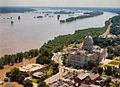
Flood waters inundated parts of Jefferson City, Missouri, and limited access to the Missouri State Capitol during the Great Flood of 1993.
|
|
| Date | April – October 1993 |
|---|---|
| Location | Illinois, Iowa, Kansas, Minnesota, Missouri, Nebraska, North Dakota, South Dakota, and Wisconsin |
| Deaths | 32 |
| Property damage | $15 billion |
The Great Flood of 1993 was a huge flood that hit the Midwestern United States. It happened along the Mississippi River and Missouri River and their smaller rivers. This massive flood lasted for several months, from April to October 1993.
It was one of the most expensive and damaging floods in U.S. history. The total cost was about $15 billion, which would be around $27 billion today. The flood covered a huge area, about 320,000 square miles (830,000 km²). The actual flooded land was about 30,000 square miles (78,000 km²). This flood was the worst U.S. disaster since the Great Mississippi Flood of 1927. It lasted longer, covered more land, forced more people from their homes, and caused more damage to crops and property. It also set many new records for river levels.
Contents
What Caused the Great Flood of 1993?
Some scientists believe a big volcano eruption in 1991, Mount Pinatubo, played a role. This eruption might have created more tiny particles in the air. These particles could have caused more clouds and rain, leading to the flood.
Starting in the summer of 1992, the Midwest had more rain than usual. Temperatures were also lower than normal. This meant the ground was very wet, and water levels in lakes and rivers were high. This wet weather continued through the fall. Then, in the winter of 1992–93, there was a lot of snow.

These conditions set the stage for disaster. In the spring, strong storms kept hitting the same areas. By June 1, the ground was completely soaked. Any new rain just ran off into streams and rivers. This was very different from the dry, hot weather in the southeastern U.S. at the same time.
During the late spring and summer, storms kept bringing huge amounts of rain to the Upper Midwest. Some places in Iowa got as much as 48 inches (122 cm) of rain in just five months. Many areas had 4 to 7.5 times their normal rainfall. In the St. Louis area, 36 river spots went above "flood stage." This means the water was high enough to cause flooding. Twenty river-level records were broken. The 1993 flood broke records from the 1973 Mississippi and 1951 Missouri River floods.
The Civil Air Patrol helped a lot during the flood. Crews from 21 states gave out over 5,000 meals to people affected by the flood and volunteers. Their pilots flew more than 1,500 hours. They checked utility lines and pipelines from the air.
Over 1,000 flood warnings were sent out to tell people about the rising river levels. In places like St. Louis, river levels were almost 20 feet (6.1 m) above flood stage. This was the highest ever recorded there in 228 years. The St. Louis Floodwall, which is 52 feet (16 m) high, was built to handle floods like the one in 1844. It managed to hold back the 1993 flood with just over 2 feet (0.6 m) to spare. This wall was built in the 1960s. If it had broken, all of downtown St. Louis would have been underwater.
Officials estimated that almost all of the 700 private farm levees along the Missouri River were covered or destroyed. Levees are walls built to hold back water. Shipping on the Mississippi and Missouri Rivers was stopped in early July. This caused a loss of $2 million per day in business.
May: Flooding Begins
The Redwood River in Minnesota started flooding badly in May. On May 22, Sioux Falls, South Dakota, got 7.5 inches (190 mm) of rain in just three hours. From May to July, Sioux Falls received 22.55 inches (573 mm) of rain. This was the wettest three-month period in its history.
June: Rivers Rise and Fall
The heavy rains in South Dakota added to the flooding downstream. In June, the Black River in Wisconsin flooded. The Mississippi River, Missouri River, and Kansas River also began to flood. Starting around June 7, many reports came in about levees being covered or breaking. These breaks temporarily held back some water in nearby low areas. But the rain kept falling.

At the start of June, the Missouri and Mississippi rivers dropped below flood stage. But in the second week of June, they rose again. By the end of June, the Mississippi River was 4 feet (1.2 m) below flood stage at St. Louis. However, many other rivers in the region were near flood stage. Rainfall for June was 1 inch (25 mm) above normal in Kansas City. It was almost 4 inches (100 mm) above normal in Springfield, Missouri.
July: The Worst of the Rain
July brought even more heavy rain to the Missouri and upper Mississippi River basins. This included Missouri, Iowa, Kansas, Nebraska, North and South Dakota, Illinois, and Minnesota. It was common to get 5 to 7 inches (130 to 180 mm) of rain in just 24 hours. Rainfall for July was 1 inch (25 mm) above normal in St. Louis. It was between 6 and 7 inches (150 and 180 mm) above normal in Columbia and Kansas City, Missouri.

In Iowa, the flood caused huge damage. On July 9, four buildings at Iowa State University flooded. This caused over $1.4 million in damage. The college's indoor sports arena, Hilton Coliseum, was flooded with up to 14 feet (4.3 m) of water. From July 11 to July 22, the Des Moines Water Works was flooded by the Raccoon River. This meant the plant shut down, and people had no running water. On July 13, President Bill Clinton visited Iowa. He declared a disaster for Iowa, Minnesota, Wisconsin, Illinois, and Missouri. He asked Congress for $2.5 billion in disaster relief. The Army National Guard and American Red Cross set up water stations. A local company even gave out water in white six-packs. When running water came back, it was not safe to drink until July 29.
People worked hard to build sandbag walls along the Missouri River, the River des Peres in St. Louis, and the Mississippi River south of St. Louis. Some of these efforts worked, but others did not. The huge amount of rain in July sent record-breaking water levels down the Mississippi and Missouri Rivers. The highest points of the flood, called "crests," met near St. Louis. Shipping on the rivers was closed in early July. This caused a loss of $2 million per day in business.
The Mississippi River levels stayed high for a few days. When the crest from the Missouri River arrived, levels rose even more. The Mississippi River broke through levees. It forced people and their belongings to higher ground. It caused chaos across the floodplains.
The combined flood crest moved downstream through St. Louis. It headed towards the Ohio River at Cairo, Illinois. Below Cairo, there was only minor flooding. This was because the Lower Mississippi River has a much wider channel. Also, the eastern U.S. was experiencing a drought. If the Ohio River area had not been in a drought, the 1993 flood might have been as bad as the 1927 flood for the Lower Mississippi.
August: Levee Breaks and New Records

On August 1, levees broke near Columbia, Illinois. This flooded 47,000 acres (190 km²) of land. It covered the Illinois towns of Valmeyer and Fults. The water kept flowing next to the river. It got close to the levees protecting historic Prairie du Rocher. On August 3, officials decided to break a stronger Mississippi River levee. This let the water flow back into the river. The plan worked, and the historic areas were saved. However, some homes in counties above Prairie du Rocher were flooded.
The Mississippi River at St. Louis reached its highest point on August 1. It was 49.6 feet (15.1 m) high, almost 20 feet (6.1 m) above flood stage. The water flowed at a rate of 1,080,000 cubic feet per second (30,600 m³/s). At this speed, a bowl the size of Busch Memorial Stadium in St. Louis would fill up in just 70 seconds!
Costs and Damage from the Flood
Some places on the Mississippi River were flooded for almost 200 days. Various areas along the Missouri River were flooded for nearly 100 days. For example, Grafton, Illinois, was flooded for 195 days. Clarksville, Missouri, was flooded for 187 days. The Missouri River was above flood stage for 62 days in Jefferson City, Missouri. It was 94 days in St. Charles. On October 7, 103 days after the flooding began, the Mississippi River at St. Louis finally dropped below flood stage.
About 100,000 homes were destroyed by the flood. Fifteen million acres (60,000 km²) of farmland were covered in water. The entire towns of Valmeyer, Illinois, and Rhineland, Missouri, had to be moved to higher ground. The floods officially caused 32 deaths. However, the real number might be closer to 50 people. The estimated damage was between $15 and $20 billion. Even after the water was gone, large amounts of sand covered the farmlands and homes.
How the 1993 Flood Compares to Other Big Floods in Kansas City
Building channels and levees changed how floods affected different areas along the Missouri River. Here's how the 1993 flood compares to two other major floods in Kansas City:
- Great Flood of 1844: This was the biggest flood in terms of how much water flowed through Kansas City. About 625,000 cubic feet (17,700 m³) of water flowed per second. However, the highest point of the flood on July 16, 1844, was almost a foot (0.3 m) lower than the 1993 flood.
- Great Flood of 1951: This flood had the second-highest water flow at 573,000 cubic feet (16,200 m³) per second. Its highest point on July 14, 1951, was almost 2 feet (0.6 m) lower than the 1844 flood. It was also 3 feet (0.9 m) lower than the 1993 flood. However, this flood was the most damaging for Kansas City. Its levee system was not strong enough. It destroyed the Kansas City Stockyards. It also led Kansas City to build Kansas City International Airport away from the river.
- Great Flood of 1993: This flood reached the highest water level in Kansas City. But it had the lowest water flow compared to the other two, at 541,000 cubic feet (15,300 m³) per second. While the 1993 flood caused huge damage elsewhere, Kansas City did relatively well. This was because of improvements made to its levee system after the 1951 flood.
Images for kids
-
Flood waters in Jefferson City, Missouri, during the Great Flood of 1993.
