Raccoon River facts for kids
Quick facts for kids Raccoon River |
|
|---|---|

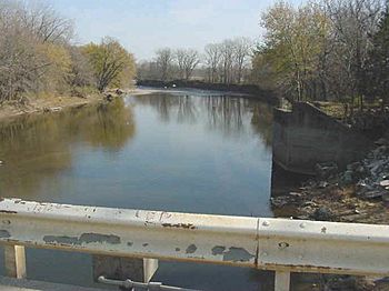
The Raccoon River at Van Meter
|
|

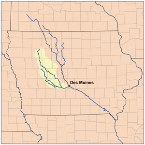
Map of the Raccoon River watershed
|
|
| Country | US |
| State | Iowa |
| District | Polk County, Iowa, Dallas County, Iowa |
| Physical characteristics | |
| Main source | 850 ft (260 m) 41°32′38″N 93°58′00″W / 41.54389°N 93.96667°W |
| River mouth | Des Moines River Des Moines, Iowa 784 ft (239 m) 41°34′46″N 93°36′44″W / 41.57944°N 93.61222°W |
| Basin features | |
| Tributaries |
|
The Raccoon River is a river in central Iowa, United States. It flows for about 30.8 miles (49.6 km) before joining the Des Moines River. If you measure its longest branch, the river is much longer, about 226 miles (364 km). The Raccoon River is an important source of drinking water for the city of Des Moines. It flows through areas with lots of farms and eventually connects to the Mississippi River system.
| Top - 0-9 A B C D E F G H I J K L M N O P Q R S T U V W X Y Z |
River History
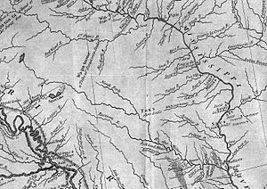
The Raccoon River was first shown on a map in 1814 by famous explorers Lewis and Clark. Later, in 1843, another map called Hydrological Basin of the Upper Mississippi River also showed the river. This map was based on measurements taken by Joseph Nicollet in the 1830s.
River Journey
The Raccoon River is a 30.8 miles (49.6 km)-long tributary (a smaller river flowing into a larger one) of the Des Moines River in central Iowa. It actually starts as three main streams, or "forks." When you measure the longest of these forks, the total length of the Raccoon River system is about 226 miles (364 km).
The river flows through many farms where crops like corn and soy are grown, and livestock are raised. The land here used to be naturally wet, but farmers have added drainage tiles to help remove water so they can grow crops.
North Raccoon River
The North Raccoon River is the longest of the three forks, stretching about 196 miles (315 km). It begins in northeastern Buena Vista County and flows south, then southeast. It passes through several counties, including Sac, Calhoun, Carroll, Greene, and Dallas. Along its path, it goes by towns like Sac City, Jefferson, Perry, and Adel. There is only one dam on this fork, called the Adel Island dam, located in Adel.
Middle Raccoon River
The Middle Raccoon River is about 92 miles (148 km) long. It starts in northwestern Carroll County and flows southeast through Guthrie and Dallas counties. Towns along its route include Carroll, Coon Rapids, Panora, Linden, and Redfield. You can also find Springbrook State Park along this fork.
There are three dams on the Middle Raccoon River:
- The Lake Panorama dam, built in 1970, helps with recreation and also reduces flooding.
- The Lennon Mill dam, located at Panora.
- The Redfield dam, located at Redfield.
The Middle Raccoon River joins the South Raccoon River about 1 mile (1.6 km) south of Redfield.
South Raccoon River
The South Raccoon River is about 72 miles (116 km) long. It starts in northeastern Audubon County and flows southeast through Guthrie and Dallas counties. It passes by the town of Guthrie Center.
After the Middle Raccoon River flows into the South Raccoon River near Redfield, there is a special flow gauge. This device helps different government groups, like the United States Army Corps of Engineers and the United States Geological Survey, collect information about the river's flow. This data is important for predicting and managing potential floods.
The North and South Raccoon River forks meet in Dallas County, just west of Van Meter. From there, the main Raccoon River flows east into Polk County, passing Walnut Woods State Park and West Des Moines. Finally, it joins the Des Moines River just south of downtown Des Moines. The water from the Raccoon River then travels through the Des Moines River and eventually into the huge Mississippi River.

Drinking Water for Des Moines
The Raccoon River and the Des Moines River have been providing drinking water for the Des Moines metropolitan area since the 1800s. Water companies use these rivers to supply clean water to homes and businesses.
The Great Flood of 1993
During the Great Flood of 1993, the Raccoon River overflowed its banks. The floodwaters reached the water treatment facility in Des Moines. This caused the facility to shut down, meaning the city of Des Moines temporarily lost its supply of drinking water. It was a big challenge for the city!
Farm Pollution and Water Quality
Sometimes, especially in spring when snow melts or after heavy rains, water washes over farmland. This water can pick up nitrates from fertilizers used on crops. These nitrates can then flow into the river.
For example, in November 2014, the amount of nitrates in the Raccoon River reached 13.7 parts per million (ppm). The United States Environmental Protection Agency says that if nitrate levels are above 10 ppm, officials need to tell the public about safety risks, especially for young children. High nitrate levels can make the water unsafe to drink. At that time, these were some of the highest nitrate readings recorded in the country.
 | Kyle Baker |
 | Joseph Yoakum |
 | Laura Wheeler Waring |
 | Henry Ossawa Tanner |


