Panora, Iowa facts for kids
Quick facts for kids
Panora, Iowa
|
|
|---|---|

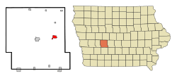
Location of Panora, Iowa
|
|
| Country | |
| State | |
| County | Guthrie |
| Area | |
| • Total | 1.81 sq mi (4.69 km2) |
| • Land | 1.81 sq mi (4.69 km2) |
| • Water | 0.00 sq mi (0.00 km2) |
| Elevation | 1,070 ft (330 m) |
| Population
(2020)
|
|
| • Total | 1,091 |
| • Density | 602.43/sq mi (232.59/km2) |
| Time zone | UTC-6 (Central (CST)) |
| • Summer (DST) | UTC-5 (CDT) |
| ZIP code |
50216
|
| Area code(s) | 641 |
| FIPS code | 19-61320 |
| GNIS feature ID | 2396137 |
| Website | www.cityofpanora.com |
Panora is a city located in Guthrie County, Iowa, in the United States. In 2020, about 1,091 people lived there. It is also part of the larger Des Moines metropolitan area.
Contents
History
Panora was founded in 1851. It is the oldest town in Guthrie County. For many years, Panora was the main government center, or "county seat." In 1876, Guthrie Center became the new county seat.
Geography
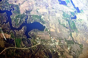
Panora is located next to the Middle Raccoon River. The city covers a total area of about 1.80 square miles (4.66 square kilometers). All of this area is land.
Population and People
| Historical populations | ||
|---|---|---|
| Year | Pop. | ±% |
| 1860 | 314 | — |
| 1870 | 504 | +60.5% |
| 1880 | 795 | +57.7% |
| 1890 | 809 | +1.8% |
| 1900 | 958 | +18.4% |
| 1910 | 1,080 | +12.7% |
| 1920 | 966 | −10.6% |
| 1930 | 1,014 | +5.0% |
| 1940 | 1,169 | +15.3% |
| 1950 | 1,062 | −9.2% |
| 1960 | 1,019 | −4.0% |
| 1970 | 982 | −3.6% |
| 1980 | 1,211 | +23.3% |
| 1990 | 1,100 | −9.2% |
| 2000 | 1,175 | +6.8% |
| 2010 | 1,124 | −4.3% |
| 2020 | 1,091 | −2.9% |
| Source: and Iowa Data Center Source: |
||
2020 Census Information
In 2020, Panora had 1,091 residents living in 449 households. The city's population density was about 602 people per square mile. Most residents, about 95.2%, were White. A small number of people were from other racial backgrounds. About 2.9% of the population identified as Hispanic or Latino.
The average age of people in Panora was 42.4 years. About 27.9% of the residents were under 20 years old. Also, 22.5% were 65 years or older. There were slightly more females (53.5%) than males (46.5%) in the city.
2010 Census Information
In 2010, Panora had 1,124 people living in 460 households. The population density was about 624 people per square mile. Most people (98.5%) were White. About 1.4% of the population was Hispanic or Latino.
The average age was 43.2 years. About 26.1% of residents were under 18. About 22.2% were 65 or older. The city had more females (55.2%) than males (44.8%).
Economy
A company called Nutriom has a factory in Panora. This factory turns about 24 million eggs each year into a special powder. This powder can later be mixed with water and heated to make scrambled eggs.
Arts and Culture
The Guthrie County Historical Village and Museum is a large museum in Panora. It covers about 4.5 acres (1.8 hectares). The museum has historic buildings, old tools, and even old train cars.
Each June, Panora hosts "Art in the Village Square." This event takes place in the Town Square Park. It features live music and displays of artwork.
"Lake Panorama Days" happens every August. This celebration includes a parade, a street dance, and a water skiing show at Lake Panorama.
Parks and Recreation
Lenon Mill Park campgrounds are located along the Middle Raccoon River. These campgrounds are part of the much larger Lenon Mill Park and Wildlife Area, which spans about 1,236 acres (5 square kilometers).
The starting point for the Raccoon River Valley Trail is in Panora. This trail is popular for walking and biking.
Veterans Auditorium was built in the 1930s. It was officially opened by WHO radio sports announcer Ronald Reagan, who later became president. This auditorium is the only part left of the original Panora-Linden High School building. The Panora Community Center is now connected to Veterans Auditorium.
Education
The Panorama Community School District serves students from kindergarten through 12th grade. This district includes students from Panora and nearby towns like Linden, Yale, Jamaica, Bagley, and Lake Panorama.
In Panora, you'll find Panorama Elementary School, which teaches students from kindergarten to 5th grade. Panorama Middle School/High School opened in 1974. It serves students from 6th to 12th grade.
Notable People
- William L. Carberry - A college football player and coach.
- Aubrey W. Dirlam - He served as a leader in the Minnesota House of Representatives.
- Kip Janvrin - A native of Panora, he is an American decathlete and track and field coach. He set a world record in the decathlon for athletes over 40 years old in 2005.
See also
 In Spanish: Panora (Iowa) para niños
 | Victor J. Glover |
 | Yvonne Cagle |
 | Jeanette Epps |
 | Bernard A. Harris Jr. |


