Jefferson, Iowa facts for kids
Quick facts for kids
Jefferson, Iowa
|
|
|---|---|

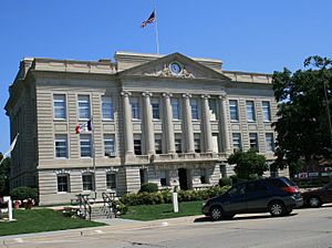
Greene County Courthouse in Jefferson
|
|

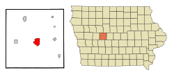
Location of Jefferson, Iowa
|
|
| Country | |
| State | |
| County | Greene |
| Area | |
| • Total | 6.01 sq mi (15.57 km2) |
| • Land | 5.97 sq mi (15.46 km2) |
| • Water | 0.04 sq mi (0.10 km2) |
| Elevation | 1,056 ft (322 m) |
| Population
(2020)
|
|
| • Total | 4,182 |
| • Density | 695.6/sq mi (268.59/km2) |
| Time zone | UTC-6 (Central (CST)) |
| • Summer (DST) | UTC-5 (CDT) |
| ZIP code |
50129
|
| Area code(s) | 515 |
| FIPS code | 19-39450 |
| GNIS feature ID | 468135 |
Jefferson is a city in Iowa, United States. It is the main city and county seat of Greene County, Iowa. The city is located along the North Raccoon River.
In 2020, about 4,182 people lived in Jefferson. The city is famous for the Mahanay Memorial Bell Tower. This tower is 168 feet (51 meters) tall. You can see it from many miles away. The tower is named after Floyd Mahanay, a kind businessman who used to live there.
An old road called the Lincoln Highway (which was once U.S. 30) goes through Jefferson. A newer U.S. Route 30 is just a mile north of the city.
Contents
History of Jefferson
Jefferson was first planned and settled a few years before 1855. The city was officially started in January 1872. It began as a farming community, and farming is still important there today.
The first family to settle in the new city was George S. Walton's family in 1855. During the American Civil War, many men from Jefferson and Greene County joined the army. They were part of the 10th Iowa Infantry (in 1861) and the 39th Iowa Infantry (in 1862).
Trains came to Jefferson in the years after the Civil War. Mahlon Head was elected as Jefferson's first mayor in 1872. The city's library was finished in 1904. It was built with money from the Carnegie library fund. The part of the Lincoln Highway that goes through Jefferson was completed around 1924.
Geography and Climate
According to the United States Census Bureau, Jefferson covers a total area of about 6.01 square miles (15.57 square kilometers). Most of this area is land, and a small part is water.
Jefferson's Climate
Jefferson has a type of climate called a hot-summer humid continental climate. This means it has warm, humid summers and cold winters.
Population Information
| Historical population | ||
|---|---|---|
| Year | Pop. | ±% |
| 1870 | 779 | — |
| 1880 | 1,444 | +85.4% |
| 1890 | 1,875 | +29.8% |
| 1900 | 2,601 | +38.7% |
| 1910 | 2,477 | −4.8% |
| 1920 | 3,416 | +37.9% |
| 1930 | 3,431 | +0.4% |
| 1940 | 4,088 | +19.1% |
| 1950 | 4,326 | +5.8% |
| 1960 | 4,570 | +5.6% |
| 1970 | 4,735 | +3.6% |
| 1980 | 4,854 | +2.5% |
| 1990 | 4,292 | −11.6% |
| 2000 | 4,626 | +7.8% |
| 2010 | 4,345 | −6.1% |
| 2020 | 4,182 | −3.8% |
| Source: Source: |
||
2020 Census Details
In 2020, there were 4,182 people living in Jefferson. There were 1,872 households, which are groups of people living together.
Most of the people (93.1%) were White. About 3.7% of the population were Hispanic or Latino.
The average age in the city was 45 years old. About 24.5% of the people were under 20 years old. Also, 25.9% were 65 years old or older. The city had slightly more females (53%) than males (47%).
2010 Census Details
In 2010, the city had 4,345 people. There were 1,900 households.
Most residents (97.9%) were White. About 2.3% of the population was Hispanic or Latino.
The average age was 46.3 years. About 22.5% of residents were under 18. And 24.2% were 65 or older. The city had more females (52.6%) than males (47.4%).
Arts and Culture
Mahanay Memorial Bell Tower
The Mahanay Memorial Bell Tower was finished in October 1966. It stands almost 14 stories tall, or 168 feet (51 meters). Floyd Mahanay left money to build the tower.
In 2016, for the tower's 50th birthday, enough money was raised to add a special set of 47 bells. These bells can play many different tunes. They are used for weddings, birthdays, funerals, and even the local high school's fight song.
Every 15 minutes, the tower plays the Westminster Chimes to tell the time. You can take an elevator to the top of the tower. From the observation deck, you can see five different counties in Iowa!
Festivals in Jefferson
Since 1980, Jefferson has held the Bell Tower Festival every year. It takes place on the second Saturday of June. The festival includes a parade in the morning and a street dance in the evening.
Education
Students in Jefferson attend schools in the Greene County Community School District. This district operates three schools in Jefferson:
- Greene County Elementary
- Greene County Middle
- Greene County High School
Before 2014, Jefferson was part of the Jefferson–Scranton Community School District. That district was formed in 1992.
Notable People from Jefferson
Many interesting people have come from Jefferson:
- Johnny Case – A professional mixed martial artist.
- George Gallup – He created the famous Gallup poll, which measures public opinion.
- William Cook Hanson – A federal judge who served from 1962 to 1995.
- Darrell R. Lindsey – He received the Medal of Honor after he died for his bravery.
- Dick Oatts – A talented jazz saxophonist.
- Bryce Paup – A professional football player who played from 1990 to 2000.
- Loren Shriver – An astronaut who traveled to space.
- Doreen Wilber – She won a Gold Medal in archery at the 1972 Olympics.
See also
 In Spanish: Jefferson (Iowa) para niños
 | William Lucy |
 | Charles Hayes |
 | Cleveland Robinson |

