Polk County, Iowa facts for kids
Quick facts for kids
Polk County
|
|||
|---|---|---|---|
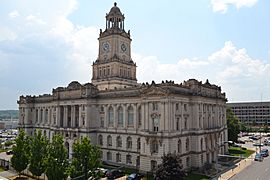
Polk County Courthouse
|
|||
|
|||
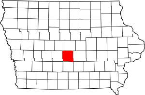
Location within the U.S. state of Iowa
|
|||
 Iowa's location within the U.S. |
|||
| Country | |||
| State | |||
| Founded | January 13, 1846 | ||
| Named for | James K. Polk | ||
| Seat | Des Moines | ||
| Largest city | Des Moines | ||
| Area | |||
| • Total | 592 sq mi (1,530 km2) | ||
| • Land | 574 sq mi (1,490 km2) | ||
| • Water | 18 sq mi (50 km2) 3.0% | ||
| Population
(2020)
|
|||
| • Total | 492,401 | ||
| • Estimate
(2023)
|
505,255 |
||
| • Density | 831.8/sq mi (321.14/km2) | ||
| Time zone | UTC−6 (Central) | ||
| • Summer (DST) | UTC−5 (CDT) | ||
| Congressional district | 3rd | ||
Polk County is a place in the state of Iowa, USA. In 2020, about 492,401 people lived there. It's the county with the most people in Iowa, home to more than 15% of everyone in the state! The main city, called the county seat, is Des Moines. This city is also the capital of Iowa. Polk County is part of a larger area called the Des Moines–West Des Moines Metropolitan Area.
Contents
History of Polk County
On January 13, 1846, the government of the Iowa Territory decided to create twelve new counties. Just a few days later, on January 17, they officially set up the governments for Jasper and Polk Counties to start on March 1, 1846. Polk County was named after James K. Polk, who was the President of the United States from 1845 to 1849.
The first building for the county government, called a courthouse, was built in Des Moines in 1846. It had two stories. But the county grew very fast! Soon, this building was too small. So, they started building a bigger one in 1858. Because of delays and the Civil War, the new courthouse wasn't finished until 1866. The courthouse you see today was built in 1906. It was updated and made larger in 1962.
Geography and Location
Polk County covers a total area of about 592 square miles. Most of this is land (574 square miles), and a smaller part (18 square miles) is water. This means about 3% of the county is water. The Des Moines River flows right through the middle of the county.
Main Roads and Highways
Many important roads run through Polk County, helping people travel around. These include major interstates and U.S. highways:
- Interstate 35
- Interstate 80
- Interstate 235
- U.S. Highway 6
- U.S. Highway 65
- U.S Route 69
- Iowa Highway 5
- Iowa Highway 17
- Iowa Highway 28
- Iowa Highway 141
- Iowa Highway 160
- Iowa Highway 163
- Iowa Highway 415
- Iowa Highway 210
Neighboring Counties
Polk County shares borders with several other counties:
- Boone – to the northwest
- Dallas – to the west
- Jasper – to the east
- Madison – to the southwest
- Marion – to the southeast
- Story – to the north
- Warren – to the south
Cities and Towns
Polk County has many different communities, from small towns to larger cities.
Cities
Other Communities
- Census-designated place: Saylorville (a community that is not an official city)
- Unincorporated communities: These are smaller places that don't have their own city government.
Population Information
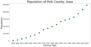
| Historical population | |||
|---|---|---|---|
| Census | Pop. | %± | |
| 1850 | 4,513 | — | |
| 1860 | 11,625 | 157.6% | |
| 1870 | 27,857 | 139.6% | |
| 1880 | 42,395 | 52.2% | |
| 1890 | 65,410 | 54.3% | |
| 1900 | 82,624 | 26.3% | |
| 1910 | 110,438 | 33.7% | |
| 1920 | 154,029 | 39.5% | |
| 1930 | 172,837 | 12.2% | |
| 1940 | 195,835 | 13.3% | |
| 1950 | 226,010 | 15.4% | |
| 1960 | 266,315 | 17.8% | |
| 1970 | 286,101 | 7.4% | |
| 1980 | 303,170 | 6.0% | |
| 1990 | 327,140 | 7.9% | |
| 2000 | 374,601 | 14.5% | |
| 2010 | 430,640 | 15.0% | |
| 2020 | 492,401 | 14.3% | |
| 2023 (est.) | 505,255 | 17.3% | |
| U.S. Decennial Census 1790–1960 1900–1990 1990–2000 2010–2020 |
|||
What the 2020 Census Showed
The census is a count of all the people living in an area. In 2020, the census showed that 492,401 people lived in Polk County. There were 207,290 households, which are groups of people living together in a home. The county had about 834 people per square mile.
Most people (92.55%) said they belonged to one race. Here's a breakdown:
- 66.18% were non-Hispanic White.
- 7.23% were Black.
- 9.76% were Hispanic.
- 4.98% were Asian.
- A small number were Native American (0.46%) or Native Hawaiian/Pacific Islander (0.06%).
- 11.33% were from other races or more than one race.
There were 210,184 housing units in total, and 196,891 of them were lived in.
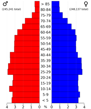
What the 2010 Census Showed
In 2010, the census counted 430,640 people in Polk County. There were 170,197 households. The population density was about 756 people per square mile. There were 182,262 housing units, and 170,197 of them were occupied.
Schools in Polk County
Polk County has many different school districts that serve its students.
- Ankeny Community School District
- Ballard Community School District
- Bondurant-Farrar Community School District
- Carlisle Community School District
- Collins-Maxwell Community School District
- Dallas Center-Grimes Community School District
- Des Moines Independent Community School District
- Johnston Community School District
- Madrid Community School District
- North Polk Community School District
- PCM Community School District
- Saydel Community School District
- Southeast Polk Community School District
- Urbandale Community School District
- West Des Moines Community School District
- Woodward-Granger Community School District
Fun Places to Visit
Polk County has many exciting attractions for families and visitors.
- Adventureland Resort - A fun amusement park with rides and games.
- Blank Park Zoo - A zoo where you can see animals from all over the world.
- Iowa State Capitol - The beautiful building where Iowa's government works.
- Iowa State Fair - A huge annual event with rides, food, and exhibits.
- Living History Farms - A place where you can experience what farm life was like in the past.
- Science Center of Iowa - A museum with hands-on science exhibits.
- Valley Junction - A historic area with unique shops and restaurants.
- Wells Fargo Arena - A large venue for sports events and concerts.
Images for kids
See also
 In Spanish: Condado de Polk (Iowa) para niños
 | Bessie Coleman |
 | Spann Watson |
 | Jill E. Brown |
 | Sherman W. White |


