Bondurant, Iowa facts for kids
Quick facts for kids
Bondurant, Iowa
|
|
|---|---|
| Motto(s):
"on the move"
|
|

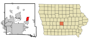
Location within Polk County and Iowa
|
|
| Country | |
| State | |
| County | Polk |
| Area | |
| • Total | 8.78 sq mi (22.73 km2) |
| • Land | 7.75 sq mi (22.66 km2) |
| • Water | 0.03 sq mi (0.07 km2) |
| Elevation | 958 ft (292 m) |
| Population
(2020)
|
|
| • Total | 7,365 |
| • Estimate
(2022)
|
8,710 |
| • Density | 995.57/sq mi (384.40/km2) |
| Time zone | UTC-6 (Central (CST)) |
| • Summer (DST) | UTC-5 (CDT) |
| ZIP code |
50035
|
| Area code(s) | 515 |
| FIPS code | 19-07390 |
| GNIS feature ID | 2394218 |
| Website | The City of Bondurant, Iowa Website |
Bondurant (/ˈbɒndʊəˌrænt/) is a city located in Polk County, Iowa, in the United States. It is part of the larger Des Moines metropolitan area. In the 2020 census, Bondurant had a population of 7,365 people. This was a big increase of over 90% from its population of 3,860 in 2010, showing the city is growing quickly!
Contents
History of Bondurant
Bondurant was first established in 1884. A few years later, in 1892, the Chicago Great Western Railway built a train station in the city. Bondurant officially became a city on December 23, 1897. The city was named after Alexander C. Bondurant, who was the first person to settle in this area back in 1857.
The 2018 Tornado
On July 19, 2018, around 3 p.m., an EF2 tornado touched down in Bondurant. An EF2 tornado is a strong tornado that can cause significant damage. This tornado was one of two EF2 tornadoes that were active at the same time in the area. Luckily, the first tornado gave a clear warning, which helped people prepare for the second one that hit Bondurant.
Geography and Location
According to the United States Census Bureau, Bondurant covers a total area of about 8.40 square miles (21.76 square kilometers). Most of this area, about 8.38 square miles (21.70 square kilometers), is land, and a small part is water.
Bondurant is located in the central part of Iowa. You can easily reach the city by using U.S. Route 65, which comes from the northeast or southwest. You can also get there from the west using NE 78th Ave.
Population and People
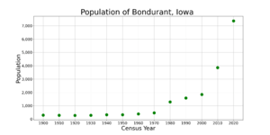
The population of Bondurant has grown a lot over the years. Here's a look at how many people have lived in the city during different census years:
- 1900: 297 people
- 1910: 287 people
- 1920: 274 people
- 1930: 289 people
- 1940: 320 people
- 1950: 328 people
- 1960: 389 people
- 1970: 462 people
- 1980: 1,283 people
- 1990: 1,584 people
- 2000: 1,846 people
- 2010: 3,860 people
- 2020: 7,365 people
Facts from the 2020 Census
In 2020, there were 7,365 people living in Bondurant. There were 2,337 households, and 1,924 of these were families. The city had about 841.8 people per square mile.
Most of the people in Bondurant were White (91.2%). Other groups included Black or African American (1.6%), Native American (0.2%), Asian (1.4%), and people from two or more races (4.7%). About 3.9% of the population was Hispanic or Latino.
The average age of people in Bondurant was 31.0 years old. A large part of the population, 38.5%, was under 20 years old. About 34.9% were between 25 and 44 years old. The number of males and females in the city was almost equal, with 50.0% male and 50.0% female.
Education in Bondurant
The public schools in the Bondurant area are managed by the Bondurant–Farrar Community School District. This district helps provide education for students living in the city and nearby areas.
Transportation
Getting around Bondurant and to other places is made easier by the Des Moines Area Regional Transit system. Route 17 provides bus service, connecting the city to the wider region.
See also
 In Spanish: Bondurant (Iowa) para niños
 | Roy Wilkins |
 | John Lewis |
 | Linda Carol Brown |


