Madison County, Iowa facts for kids
Quick facts for kids
Madison County
|
|
|---|---|

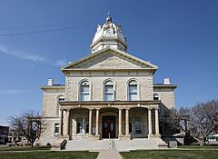
Madison County courthouse
|
|

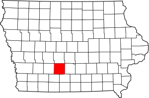
Location within the U.S. state of Iowa
|
|
 Iowa's location within the U.S. |
|
| Country | |
| State | |
| Founded | 1846 |
| Named for | James Madison |
| Seat | Winterset |
| Largest city | Winterset |
| Area | |
| • Total | 562 sq mi (1,460 km2) |
| • Land | 561 sq mi (1,450 km2) |
| • Water | 1.2 sq mi (3 km2) 0.2% |
| Population
(2020)
|
|
| • Total | 16,548 |
| • Estimate
(2023)
|
16,971 |
| • Density | 29.445/sq mi (11.369/km2) |
| Time zone | UTC−6 (Central) |
| • Summer (DST) | UTC−5 (CDT) |
| Congressional district | 3rd |
Madison County is a county in the state of Iowa, USA. In 2020, about 16,548 people lived here. The main town and county seat is Winterset.
Madison County is part of the larger Des Moines area. It is famous for two main things: it's the birthplace of actor John Wayne, and it has several beautiful covered bridges. These bridges became well-known from the 1992 book The Bridges of Madison County, and later from the movie and musical based on it.
Contents
History
Madison County was created on January 13, 1846. It started governing itself in 1849. The county was named after James Madison (1751–1836). He was the fourth President of the United States, serving from 1809 to 1817. The first European-American settler in Madison County was Hiram Hurst. He arrived from Missouri around April 15, 1846.
Geography
Madison County covers a total area of about 562 square miles (1,456 square kilometers). Most of this area, about 561 square miles (1,453 square kilometers), is land. Only a small part, about 1.2 square miles (3.1 square kilometers), is water.
Main Roads
 Interstate 80 (This highway crosses the far northwestern part of the county.)
 U.S. Highway 6
 U.S. Highway 169
 Iowa Highway 92
Neighboring Counties
Madison County shares borders with these counties:
- Dallas County (to the north)
- Warren County (to the east)
- Clarke County (to the southeast)
- Union County (to the southwest)
- Adair County (to the west)
- Polk County (to the northeast, where their corners meet)
Population Information
| Historical population | |||
|---|---|---|---|
| Census | Pop. | %± | |
| 1850 | 1,179 | — | |
| 1860 | 7,339 | 522.5% | |
| 1870 | 13,884 | 89.2% | |
| 1880 | 17,224 | 24.1% | |
| 1890 | 15,977 | −7.2% | |
| 1900 | 17,710 | 10.8% | |
| 1910 | 15,621 | −11.8% | |
| 1920 | 15,020 | −3.8% | |
| 1930 | 14,331 | −4.6% | |
| 1940 | 14,525 | 1.4% | |
| 1950 | 13,131 | −9.6% | |
| 1960 | 12,295 | −6.4% | |
| 1970 | 11,558 | −6.0% | |
| 1980 | 12,597 | 9.0% | |
| 1990 | 12,483 | −0.9% | |
| 2000 | 14,019 | 12.3% | |
| 2010 | 15,679 | 11.8% | |
| 2020 | 16,548 | 5.5% | |
| 2023 (est.) | 16,971 | 8.2% | |
| U.S. Decennial Census 1790-1960 1900-1990 1990-2000 2010-2018 |
|||
2020 Census Details

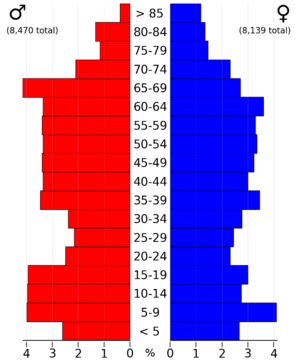
The 2020 census counted 16,548 people in Madison County. This means there were about 29 people living in each square mile. Most people (about 96%) reported being of one race. About 92% were non-Hispanic White. Other groups included Hispanic, Black, Native American, and Asian people. There were 6,913 homes in the county, and 6,436 of them were lived in.
2010 Census Details
In 2010, the census showed that 15,679 people lived in Madison County. The population density was about 28 people per square mile. There were 6,554 housing units, and 6,025 of them were occupied.
Famous Covered Bridges
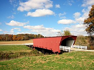
Madison County is famous for its covered bridges. Originally, there were nineteen, but now only six remain. These bridges are special because they have roofs and sides, which protect the wooden structure from weather.
Here are the remaining covered bridges:
- Cedar Bridge: Built in 1883, it was 76 feet (23 meters) long. It was destroyed by fire in 2002 but rebuilt in 2004. Sadly, the rebuilt bridge was also destroyed by fire in 2017.
- Cutler-Donahoe Bridge: Built in 1870, this bridge is 79 feet (24 meters) long.
- Hogback Covered Bridge: Built in 1884, it measures 97 feet (30 meters) long.
- Holliwell Bridge: Built in 1880, this bridge is 122 feet (37 meters) long. It was featured in the 1995 movie The Bridges of Madison County.
- Imes Bridge: Built in 1870, it is 81 feet (25 meters) long.
- Roseman Covered Bridge: Built in 1883, this 107-foot (33-meter) long bridge is the most well-known. It was also featured in the 1995 movie The Bridges of Madison County.
Most of these bridges were designed by Harvey P. Jones and George K. Foster. However, Eli Cox built the Cutler-Donahoe Bridge, and J. P. Clark built the Imes Bridge.
The Only Highway Tunnel
Madison County has something unique: the only highway tunnel in all of Iowa! It's called Harmon Tunnel. This tunnel goes through a narrow part of land next to the Middle River in Pammel Park.
Communities in Madison County
Cities and Towns
Smaller Communities (Unincorporated)
These are smaller places that are not officially cities or towns:
Townships
Townships are smaller areas within a county, often used for local government or land division.
- Crawford
- Douglas
- Grand River
- Jackson
- Jefferson
- Lee
- Lincoln
- Madison
- Monroe
- Ohio
- Penn
- Scott
- South
- Union
- Walnut
- Webster
Population Ranking of Cities and Towns
This table shows the population of the cities and towns in Madison County, based on the 2020 census.
† county seat
| Rank | City/Town/etc. | Type | Population (2020 Census) |
|---|---|---|---|
| 1 | † Winterset | City | 5,353 |
| 2 | Earlham | City | 1,410 |
| 3 | St. Charles | City | 640 |
| 4 | Truro | City | 509 |
| 5 | Patterson | City | 176 |
| 6 | East Peru | City | 115 |
| 7 | Macksburg | City | 97 |
| 8 | Bevington (partially in Warren County) | City | 57 |
See also
 In Spanish: Condado de Madison (Iowa) para niños
 | Lonnie Johnson |
 | Granville Woods |
 | Lewis Howard Latimer |
 | James West |


