Clarke County, Iowa facts for kids
Quick facts for kids
Clarke County
|
|
|---|---|

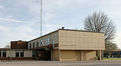
Clarke County Courthouse in Osceola
|
|

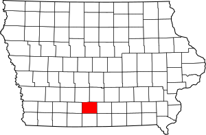
Location within the U.S. state of Iowa
|
|
 Iowa's location within the U.S. |
|
| Country | |
| State | |
| Founded | January 13, 1846 |
| Named for | James Clarke |
| Seat | Osceola |
| Largest city | Osceola |
| Area | |
| • Total | 432 sq mi (1,120 km2) |
| • Land | 431 sq mi (1,120 km2) |
| • Water | 0.6 sq mi (2 km2) 0.1% |
| Population
(2020)
|
|
| • Total | 9,748 |
| • Density | 22.565/sq mi (8.712/km2) |
| Time zone | UTC−6 (Central) |
| • Summer (DST) | UTC−5 (CDT) |
| Congressional district | 2nd |
Clarke County is a county in the state of Iowa. In 2020, about 9,748 people lived here. The main town and county seat is Osceola.
Clarke County was created in January 1846. It was one of twelve counties made at that time. The county was named after James Clarke. He was a governor of the Iowa Territory.
Contents
History of Clarke County
The first building used as a courthouse in Clarke County was a two-story wooden building in Osceola. In 1883, a new brick courthouse was built in the town square.
By the 1950s, this building was too small. A new, modern courthouse was finished in 1956. This building, the current courthouse, was added to the National Register of Historic Places in 2018.
Geography and Location
Clarke County covers about 432 square miles. Most of this area is land, about 431 square miles. A small part, about 0.6 square miles, is water.
Counties Nearby
Clarke County shares borders with several other counties:
- Decatur County to the south
- Lucas County to the east
- Madison County to the northwest
- Union County to the west
- Warren County to the northeast
Major Roads and Highways
Several important roads pass through Clarke County:
 Interstate 35: This highway runs north and south through the middle of the county. It goes through Osceola.
 U.S. Highway 34: This highway runs east and west through the middle of the county. It also passes through Osceola.
 U.S. Highway 69: This highway enters the county from the northeast. It goes southwest to Osceola, then south to the county line.
Public Transportation
- Osceola station: This is a train station in Osceola.
Towns and Communities
Clarke County has several towns and smaller communities.
Cities in Clarke County
Smaller Unincorporated Communities
- Hopeville
- Jamison
- Lacelle
- Liberty
- Ottawa
- Smyrna
Townships in Clarke County
Townships are smaller areas within a county. Clarke County has twelve townships:
- Doyle
- Franklin
- Fremont
- Green Bay
- Jackson
- Knox
- Liberty
- Madison
- Osceola
- Troy
- Ward
- Washington
Population and Demographics
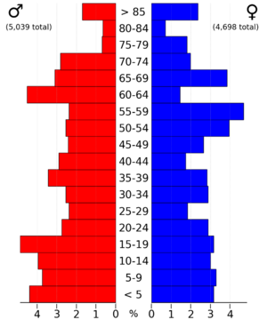
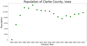
The population of Clarke County has changed over the years.
| Historical population | |||
|---|---|---|---|
| Census | Pop. | %± | |
| 1850 | 79 | — | |
| 1860 | 5,427 | 6,769.6% | |
| 1870 | 8,735 | 61.0% | |
| 1880 | 11,513 | 31.8% | |
| 1890 | 11,332 | −1.6% | |
| 1900 | 12,440 | 9.8% | |
| 1910 | 10,736 | −13.7% | |
| 1920 | 10,506 | −2.1% | |
| 1930 | 10,384 | −1.2% | |
| 1940 | 10,233 | −1.5% | |
| 1950 | 9,369 | −8.4% | |
| 1960 | 8,222 | −12.2% | |
| 1970 | 7,581 | −7.8% | |
| 1980 | 8,612 | 13.6% | |
| 1990 | 8,287 | −3.8% | |
| 2000 | 9,133 | 10.2% | |
| 2010 | 9,286 | 1.7% | |
| 2020 | 9,748 | 5.0% | |
| 2023 (est.) | 9,588 | 3.3% | |
| U.S. Decennial Census 1790-1960 1900-1990 1990-2000 2010-2018 |
|||
Population in 2020
In 2020, the county's population was 9,748 people. This means there were about 22 people living per square mile. Most people (about 93%) reported being of one race. There were 4,268 homes in the county, and 3,871 of them were lived in.

Population in 2010
In 2010, Clarke County had 9,286 people. There were 4,086 homes, and 3,701 of them were lived in.
Ranking of Cities by Population
The table below shows the cities in Clarke County, ranked by how many people lived there in 2020.
† county seat
| Rank | City/Town/etc. | Type | Population (2020 Census) |
|---|---|---|---|
| 1 | † Osceola | City | 5,415 |
| 2 | Murray | City | 684 |
| 3 | Woodburn | City | 146 |
| 4 | Weldon (mostly in Decatur County) | City | 136 |
See also
 In Spanish: Condado de Clarke (Iowa) para niños
 | Valerie Thomas |
 | Frederick McKinley Jones |
 | George Edward Alcorn Jr. |
 | Thomas Mensah |


