Murray, Iowa facts for kids
Quick facts for kids
Murray, Iowa
|
|
|---|---|

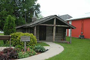
Mormon Pioneer National Historic Trail exhibit
|
|
| Motto(s):
Murray Matters
|
|

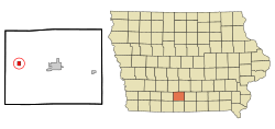
Location of Murray, Iowa
|
|
| Country | |
| State | |
| County | Clarke |
| Government | |
| • Type |
Mayor – Council
|
| Area | |
| • Total | 0.8 sq mi (2 km2) |
| • Land | 0.8 sq mi (2 km2) |
| • Water | 0.0 sq mi (0.0 km2) |
| Elevation | 1,217 ft (371 m) |
| Population
(2020)
|
|
| • Total | 684 |
| • Density | 855.00/sq mi (330.17/km2) |
| Time zone |
02:11, February 15, 2026 (CT) ()
|
| ZIP code |
50174
→ 501 + |
| Area code(s) | 641 |
| FIPS code | 19-55065 |
| GNIS feature ID | 2395142 |
Murray is a small city located in Clarke County, Iowa, in the United States. In 2020, about 684 people lived there. It's a friendly place with a rich history.
Contents
Discovering Murray's Past
Murray began in 1868. It was first called Oakland. The city grew because a railroad, the Burlington & Missouri River Rail Road, was built through the area.
How Murray Was Founded
Two men, Henry Clay Sigler and Smith Henderson Mallory, planned the village in 1868. The first post office in Oakland opened in the fall of 1868. Albert Straub became the first postmaster. He had served in the Union Army during the American Civil War.
Becoming an Official City
Murray officially became a city on October 21, 1880. This was many years after Clarke County itself was created. The city's first council meeting was held on December 7, 1880. Alanson Bowers was the first mayor of Murray. He served until March 1882.
Exploring Murray's Location
Murray is in the western part of Clarke County, Iowa. The city covers about 0.8 square miles of land. It is located along the historic Mormon Trail.
Getting Around Murray
Here are some distances from Murray to other cities:
- Osceola, which is the county seat, is about 10 miles (16 km) east. You can get there using U.S. Route 34.
- Des Moines is about 57.6 miles (92.7 km) north. You can reach it by taking I-35.
- Omaha is about 122 miles (196 km) west. You can get there using U.S. Route 34.
Understanding Murray's Population
| Historical populations | ||
|---|---|---|
| Year | Pop. | ±% |
| 1880 | 491 | — |
| 1890 | 666 | +35.6% |
| 1900 | 949 | +42.5% |
| 1910 | 796 | −16.1% |
| 1920 | 847 | +6.4% |
| 1930 | 828 | −2.2% |
| 1940 | 857 | +3.5% |
| 1950 | 767 | −10.5% |
| 1960 | 613 | −20.1% |
| 1970 | 620 | +1.1% |
| 1980 | 703 | +13.4% |
| 1990 | 731 | +4.0% |
| 2000 | 766 | +4.8% |
| 2010 | 756 | −1.3% |
| 2020 | 684 | −9.5% |
| Source: 2020 U.S. Census | ||
Murray's Population in 2020
The census in 2020 counted 684 people living in Murray. There were 297 households in the city. The population density was about 855 people per square mile.
Many types of families live in Murray. About 26% of households had children under 18. The average age of people in Murray was about 40 years old.
Murray's Population in 2010
In the 2010 census, Murray had 756 people. There were 310 households. The population density was about 957 people per square mile.
About 31% of households had children under 18. The average age in the city was about 36.8 years.
Famous People from Murray
Some notable people have come from Murray:
- Meridel Le Sueur (1900–1996) – She was an American writer. She was known for her writings during the 1930s and 1940s.
- Glenn Parker (1898–1989) – He was a Justice on the Wyoming Supreme Court. He served from 1955 to 1975. He was also the Chief Justice for two terms.
Historical Markers in Murray
You can find historical markers that tell Murray's story:
- The Ensign Peak Foundation has a .
- The Clarke County Freedom Rock & Honor Wall is in Murray Cemetery. It was created by a famous painter named Ray “Bubba" Sorensen.
See also
 In Spanish: Murray (Iowa) para niños
 | Laphonza Butler |
 | Daisy Bates |
 | Elizabeth Piper Ensley |

