Decatur County, Iowa facts for kids
Quick facts for kids
Decatur County
|
|
|---|---|

|
|

Location within the U.S. state of Iowa
|
|
 Iowa's location within the U.S. |
|
| Country | |
| State | |
| Founded | 1846 |
| Named for | Stephen Decatur Jr. |
| Seat | Leon |
| Largest city | Lamoni |
| Area | |
| • Total | 533 sq mi (1,380 km2) |
| • Land | 532 sq mi (1,380 km2) |
| • Water | 1.6 sq mi (4 km2) 0.3% |
| Population
(2020)
|
|
| • Total | 7,645 |
| • Density | 14.343/sq mi (5.538/km2) |
| Time zone | UTC−6 (Central) |
| • Summer (DST) | UTC−5 (CDT) |
| Congressional district | 3rd |
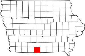
Decatur County is a county found in the state of Iowa, USA. In 2020, about 7,645 people lived here. The main town, or county seat, is Leon. This county got its name from Stephen Decatur Jr., a brave hero from the War of 1812.
Contents
History of Decatur County
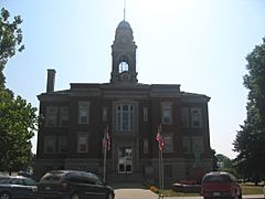
Decatur County was officially created in 1850. It was named after Stephen Decatur, a famous naval hero. He was known for his bravery during the War of 1812. The main building for the county, called the courthouse, was finished in 1908.
Geography and Location
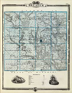
Decatur County covers a total area of about 533 square miles. Most of this area, about 532 square miles, is land. Only a small part, about 1.6 square miles, is water.
Main Roads in the County
You can find these important roads in Decatur County:
 Interstate 35
 U.S. Highway 69
 Iowa Highway 2
Public Transport
- Jefferson Lines offers bus services in the area.
Neighboring Counties
Decatur County shares its borders with several other counties:
- Clarke County (to the north)
- Wayne County (to the east)
- Mercer County, Missouri (to the southeast)
- Harrison County, Missouri (to the southwest)
- Ringgold County (to the west)
Population and People
| Historical population | |||
|---|---|---|---|
| Census | Pop. | %± | |
| 1850 | 965 | — | |
| 1860 | 8,677 | 799.2% | |
| 1870 | 12,018 | 38.5% | |
| 1880 | 15,336 | 27.6% | |
| 1890 | 15,643 | 2.0% | |
| 1900 | 18,115 | 15.8% | |
| 1910 | 16,347 | −9.8% | |
| 1920 | 16,566 | 1.3% | |
| 1930 | 14,903 | −10.0% | |
| 1940 | 14,012 | −6.0% | |
| 1950 | 12,601 | −10.1% | |
| 1960 | 10,539 | −16.4% | |
| 1970 | 9,737 | −7.6% | |
| 1980 | 9,794 | 0.6% | |
| 1990 | 8,338 | −14.9% | |
| 2000 | 8,689 | 4.2% | |
| 2010 | 8,457 | −2.7% | |
| 2020 | 7,645 | −9.6% | |
| 2023 (est.) | 7,665 | −9.4% | |
| U.S. Decennial Census 1790-1960 1900-1990 1990-2000 2010-2018 |
|||
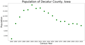
Population in 2020
The 2020 census counted 7,645 people living in Decatur County. This means there were about 14 people for every square mile. Most people, about 96.44%, said they belonged to one race. There were 3,653 homes in the county, and 2,986 of them were lived in.
County Leaders
These are some of the people who help run Decatur County:
Supervisors
- Steve Fulkerson
- Doug Tharp
- Ward Graham
Treasurer
- Janet Pierson
Attorney
- Alan Wilson
Auditor
- Charlene Hoover
Recorder
- Erica Cook
Sheriff
- Chris Lane
Assessor
- Justin Cornett
Engineer
- Justin Savage
Clerk of Court
- Traci Tharp
Public Health Administrator
- Shelley Bickel
Veterans Affairs Administrator
- Samantha Schaff
Conservation Director
- Kayla Clausen
Mental Health Director
- Kathy Lerma
Towns and Areas
Cities in Decatur County
Townships in the County
Decatur County is also divided into smaller areas called townships:
- Bloomington
- Burrell
- Center
- Decatur
- Eden
- Fayette
- Franklin
- Garden Grove
- Grand River
- Hamilton
- High Point
- Long Creek
- Morgan
- New Buda
- Richland
- Woodland
City Sizes by Population
This table shows the cities in Decatur County, ranked by how many people lived there in 2020.
† This symbol means it's the county seat, or main town.
| Rank | City/Town/etc. | Type | Population (2020 Census) |
|---|---|---|---|
| 1 | Lamoni | City | 1,969 |
| 2 | † Leon | City | 1,822 |
| 3 | Grand River | City | 196 |
| 4 | Davis City | City | 179 |
| 5 | Van Wert | City | 178 |
| 6 | Decatur City | City | 175 |
| 7 | Garden Grove | City | 174 |
| 8 | Weldon (partially in Clarke County) | City | 136 |
| 9 | Pleasanton | City | 32 |
| 10 | Le Roy | City | 11 |
See also
 In Spanish: Condado de Decatur (Iowa) para niños
 | Ernest Everett Just |
 | Mary Jackson |
 | Emmett Chappelle |
 | Marie Maynard Daly |


