Harrison County, Missouri facts for kids
Quick facts for kids
Harrison County
|
|
|---|---|

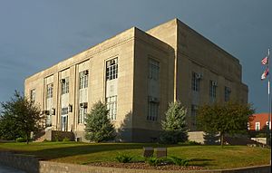
Harrison County Courthouse in Bethany
|
|

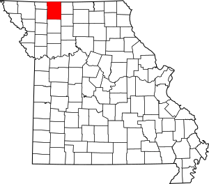
Location within the U.S. state of Missouri
|
|
 Missouri's location within the U.S. |
|
| Country | |
| State | |
| Founded | February 14, 1845 |
| Named for | Albert G. Harrison |
| Seat | Bethany |
| Largest city | Bethany |
| Area | |
| • Total | 726 sq mi (1,880 km2) |
| • Land | 723 sq mi (1,870 km2) |
| • Water | 3.9 sq mi (10 km2) 0.5% |
| Population
(2020)
|
|
| • Total | 8,157 |
| • Estimate
(2024)
|
8,186 |
| • Density | 11.3/sq mi (4.4/km2) |
| Time zone | UTC−6 (Central) |
| • Summer (DST) | UTC−5 (CDT) |
| Congressional district | 6th |
| Website | https://www.mocounties.com/harrison-county |
Harrison County is a county in the northwest part of Missouri, a state in the United States. In 2020, about 8,157 people lived here. The main town and county seat is Bethany. The county was started on February 14, 1845. It was named after Albert G. Harrison, who was a U.S. Representative from Missouri.
Contents
Exploring Harrison County's Geography
Harrison County covers a total area of about 726 square miles. Most of this area, about 723 square miles, is land. The rest, about 3.9 square miles, is water.
Neighboring Counties
Harrison County shares borders with several other counties:
- Ringgold County, Iowa (to the north)
- Decatur County, Iowa (to the northeast)
- Mercer County (to the east)
- Grundy County (to the southeast)
- Daviess County (to the south)
- Gentry County (to the southwest)
- Worth County (to the northwest)
Main Roads and Transportation
Several important highways run through Harrison County, making it easy to travel.
 Interstate 35
 U.S. Route 69
 U.S. Route 136
 Route 13
 Route 46
 Route 146
For public transportation, Jefferson Lines offers bus services.
People and Population in Harrison County
| Historical population | |||
|---|---|---|---|
| Census | Pop. | %± | |
| 1850 | 2,447 | — | |
| 1860 | 10,601 | 333.2% | |
| 1870 | 14,635 | 38.1% | |
| 1880 | 20,304 | 38.7% | |
| 1890 | 21,033 | 3.6% | |
| 1900 | 24,398 | 16.0% | |
| 1910 | 20,466 | −16.1% | |
| 1920 | 19,719 | −3.6% | |
| 1930 | 17,233 | −12.6% | |
| 1940 | 16,525 | −4.1% | |
| 1950 | 14,107 | −14.6% | |
| 1960 | 11,603 | −17.8% | |
| 1970 | 10,257 | −11.6% | |
| 1980 | 9,890 | −3.6% | |
| 1990 | 8,469 | −14.4% | |
| 2000 | 8,850 | 4.5% | |
| 2010 | 8,957 | 1.2% | |
| 2020 | 8,157 | −8.9% | |
| 2024 (est.) | 8,186 | −8.6% | |
| U.S. Decennial Census 1790-1960 1900-1990 1990-2000 2010-2015 2024 |
|||
In 2010, there were 8,957 people living in Harrison County. Most residents, about 97.55%, were White. About 1.57% of the population was Hispanic or Latino.
The average age in the county was 42.6 years. About 24.80% of the population was under 18 years old. The median income for a family was around $47,788.
Religious Beliefs
Many people in Harrison County are Protestant Christians. However, a large part of the population, about 37.69%, does not follow any specific religion. Among those who do, the most common groups are Southern Baptists and United Methodists.
2020 Census Snapshot
In 2020, the population was 8,157.
| Race | Num. | Perc. |
|---|---|---|
| White (NH) | 7,618 | 93.4% |
| Black or African American (NH) | 32 | 0.4% |
| Native American (NH) | 30 | 0.37% |
| Asian (NH) | 23 | 0.28% |
| Pacific Islander (NH) | 3 | 0.04% |
| Other/Mixed (NH) | 283 | 3.47% |
| Hispanic or Latino | 168 | 2.1% |
Learning and Schools
Harrison County has several school districts that serve its communities.
School Districts
- Cainsville R-I School District
- Gilman City R-IV School District
- North Daviess R-III School District
- North Harrison R-III School District
- Ridgeway R-V School District
- South Harrison County R-II School District
Public Schools
- Cainsville R-I School District in Cainsville has an elementary and a high school.
- Gilman City R-IV School District in Gilman City also has elementary and high schools.
- North Harrison County R-III School District in Eagleville includes elementary and high schools.
- Ridgeway R-V School District in Ridgeway has elementary and high schools.
- South Harrison County R-II School District in Bethany offers early childhood education, elementary, and high school.
Private Schools
- Zadie Creek School in Eagleville is a private school for grades 2-9. It is an Amish school.
Public Libraries
- The Bethany Public Library serves the community of Bethany.
Towns and Villages
Harrison County is home to several communities, from larger cities to smaller villages and unincorporated areas.
Cities
- Bethany (This is the county seat)
- Cainsville
- Gilman City
- New Hampton
- Ridgeway
Villages
Unincorporated Communities
These are smaller places without their own local government.
Townships
Townships are smaller divisions of the county, often used for local administration.
- Adams
- Bethany
- Butler
- Clay
- Colfax
- Cypress
- Dallas
- Fox Creek
- Grant
- Hamilton
- Jefferson
- Lincoln
- Madison
- Marion
- Sherman
- Sugar Creek
- Trail Creek
- Union
- Washington
- White Oak
Famous People from Harrison County
Some notable individuals have connections to Harrison County:
- Babe Adams - A professional baseball pitcher who played from 1906 to 1926.
- Leonard Boswell - A politician.
- Frank Buckles - The last American veteran who fought in World War I.
- Jesse N. Funk - A hero from World War I who received the Medal of Honor.
- Tyler Luellen - A football player for the University of Missouri from 2003-2007.
Understanding Politics in Harrison County
Politics in Harrison County are mostly controlled by the Republican Party. Republicans hold almost all the elected positions in the county.
Local Government
The local government in Harrison County is run by elected officials, most of whom are Republicans. These officials manage different parts of the county's services.
| Harrison County, Missouri | ||||
|---|---|---|---|---|
| Elected countywide officials | ||||
| Assessor | Lila Mae Craig | Republican | ||
| Circuit Clerk | C. Sherece Eivins | Republican | ||
| County Clerk | Greta Bottcher | Republican | ||
| Collector | Cheryl Coleman | Republican | ||
| Commissioner (Presiding) |
Jack W. Hodge | Republican | ||
| Commissioner (District 1) |
Rick J. Smith | Republican | ||
| Commissioner (District 2) |
Jim Holcomb | Republican | ||
| Coroner | Zach Wilson | Republican | ||
| Prosecuting Attorney | Alex VanZandt | Republican | ||
| Public Administrator | Kimberly King | Republican | ||
| Recorder | C. Sherece Eivins | Republican | ||
| Sheriff | Trevor Place | Republican | ||
| Surveyor | Edgar Lawrence | Republican | ||
| Treasurer | Cheryl Coleman | Republican | ||
State and Federal Politics
Harrison County is part of Missouri's 2nd District in the Missouri House of Representatives. It is also part of Missouri's 12th District in the Missouri Senate. The county is represented by Republican politicians at both state and federal levels.
For example, in the U.S. House of Representatives, Harrison County is in Missouri's 6th Congressional District. This district is currently represented by Sam Graves, a Republican. In the U.S. Senate, Missouri is represented by Josh Hawley and Eric Schmitt, both Republicans.
Harrison County usually votes for Republican candidates in presidential elections. For example, Donald Trump won easily in the county in both the 2016 and 2020 presidential elections. The last time a Democratic presidential candidate won in Harrison County was Bill Clinton in 1992.
Voters in Harrison County often support ideas that are socially conservative. For instance, in 2004, they strongly voted to define marriage as between a man and a woman. However, they also tend to support populist ideas, like increasing the minimum wage. In 2006, Harrison County voters approved raising the minimum wage. In 2018, they voted to overturn a "right to work" law, showing their support for workers' rights.
Presidential Primary Elections
Presidential primary elections help parties choose their candidate for president.
2020 Primaries
In the 2020 Democratic primary, Joe Biden won in Harrison County. He later became president. In the Republican primary, Donald Trump won overwhelmingly in Harrison County and across the state.
2016 Primaries
In the 2016 Republican primary, Donald Trump received the most votes in Harrison County. He went on to win the presidency. For the Democrats, Bernie Sanders narrowly won in Harrison County, even though Hillary Clinton won the state overall.
2012 Primaries
In the 2012 Republican primary, voters in Harrison County supported Rick Santorum. However, Mitt Romney eventually won the nomination. Barack Obama easily won the Democratic primary and was re-elected president.
2008 Primaries
In the 2008 Republican primary, John McCain won in Harrison County and became the party's nominee. On the Democratic side, Hillary Clinton received the most votes in Harrison County. However, Barack Obama won the statewide primary and later became president.
More Information
- National Register of Historic Places listings in Harrison County, Missouri
See also
 In Spanish: Condado de Harrison (Misuri) para niños
 | DeHart Hubbard |
 | Wilma Rudolph |
 | Jesse Owens |
 | Jackie Joyner-Kersee |
 | Major Taylor |

