Cainsville, Missouri facts for kids
Quick facts for kids
Cainsville, Missouri
|
|
|---|---|

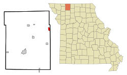
Location of Cainsville, Missouri
|
|
| Country | United States |
| State | Missouri |
| County | Harrison |
| Area | |
| • Total | 1.37 sq mi (3.55 km2) |
| • Land | 1.37 sq mi (3.55 km2) |
| • Water | 0.00 sq mi (0.00 km2) |
| Elevation | 869 ft (265 m) |
| Population
(2020)
|
|
| • Total | 283 |
| • Density | 206.42/sq mi (79.69/km2) |
| Time zone | UTC-6 (Central (CST)) |
| • Summer (DST) | UTC-5 (CDT) |
| ZIP code |
64632
|
| Area code(s) | 660 |
| FIPS code | 29-10342 |
| GNIS feature ID | 2393490 |
Cainsville is a small city located in the eastern part of Harrison County, Missouri, in the United States. In 2020, about 283 people lived there. It's a quiet place with a history that goes back to the mid-1800s.
Contents
History of Cainsville
Cainsville began in 1854. A man named Peter Cain built a watermill there. A watermill uses the power of flowing water to grind grain. As more people came to work at the mill, a small community started to grow.
By 1858, Cainsville had a post office, a blacksmith shop, and a trading post. These places were important for people living and working in the area.
Where is Cainsville?
Cainsville is located in Missouri, near the border of Harrison and Mercer counties. It sits on the east side of the Thompson River floodplain. A floodplain is a flat area of land next to a river that can sometimes flood.
The city is found where Missouri routes N and V meet. It is about seven miles north of Mount Moriah. Another town, Princeton, is about ten miles to the east-southeast.
The United States Census Bureau says that Cainsville covers a total area of about 1.37 square miles (3.55 square kilometers). All of this area is land.
People Living in Cainsville
The number of people living in Cainsville has changed over the years. Here's how the population has grown and shrunk:
| Historical population | |||
|---|---|---|---|
| Census | Pop. | %± | |
| 1880 | 198 | — | |
| 1890 | 418 | 111.1% | |
| 1900 | 743 | 77.8% | |
| 1910 | 887 | 19.4% | |
| 1920 | 1,051 | 18.5% | |
| 1930 | 765 | −27.2% | |
| 1940 | 765 | 0.0% | |
| 1950 | 618 | −19.2% | |
| 1960 | 495 | −19.9% | |
| 1970 | 454 | −8.3% | |
| 1980 | 496 | 9.3% | |
| 1990 | 387 | −22.0% | |
| 2000 | 370 | −4.4% | |
| 2010 | 290 | −21.6% | |
| 2020 | 283 | −2.4% | |
| U.S. Decennial Census | |||
Cainsville's Population in 2010
In 2010, the census counted 290 people living in Cainsville. There were 126 households, which are groups of people living together in one home. Out of these, 83 were families.
Most people in Cainsville were White. A small number were Native American or Pacific Islander. About 1% of the population identified as Hispanic or Latino.
About 28% of the households had children under 18 years old. Many households (52%) were married couples living together. Some households were led by a single parent. About 31% of all households had only one person living there.
The average age of people in Cainsville in 2010 was about 45 years old.
- About 21% of residents were under 18.
- About 8% were between 18 and 24.
- About 21% were between 25 and 44.
- About 29% were between 45 and 64.
- About 21% were 65 years old or older.
Slightly more than half of the population (51.7%) was female, and 48.3% was male.
See also
 In Spanish: Cainsville (Misuri) para niños
 | Janet Taylor Pickett |
 | Synthia Saint James |
 | Howardena Pindell |
 | Faith Ringgold |

