Mount Moriah, Missouri facts for kids
Quick facts for kids
Mount Moriah, Missouri
|
|
|---|---|

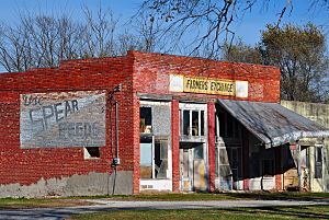
Old Farmers Exchange building
|
|

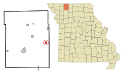
Location of Mount Moriah, Missouri
|
|
| Country | United States |
| State | Missouri |
| County | Harrison |
| Area | |
| • Total | 1.02 sq mi (2.64 km2) |
| • Land | 1.02 sq mi (2.64 km2) |
| • Water | 0.00 sq mi (0.00 km2) |
| Elevation | 837 ft (255 m) |
| Population
(2020)
|
|
| • Total | 75 |
| • Density | 73.53/sq mi (28.39/km2) |
| Time zone | UTC-6 (Central (CST)) |
| • Summer (DST) | UTC-5 (CDT) |
| ZIP code |
64481
|
| Area code(s) | 660 |
| FIPS code | 29-50528 |
| GNIS feature ID | 2396791 |
Mount Moriah is a small village located in the eastern part of Harrison County, in the state of Missouri, United States. In 2020, about 75 people lived there.
Contents
A Look at Mount Moriah's History
Mount Moriah got its own post office in 1867. This post office served the village for many years, closing in 1983. The village's name probably comes from "Moriah", a special place mentioned in an ancient religious book called the Hebrew Bible.
Where is Mount Moriah Located?
Mount Moriah is found on the west side of the Thompson River floodplain. It is located near U.S. Route 136, a main road. The city of Bethany is about fifteen miles southwest along this route. Princeton is about ten miles to the east-northeast in Mercer County.
The United States Census Bureau says the village covers a total area of about 1.02 square miles (2.64 square kilometers). All of this area is land, with no water.
Mount Moriah's Population Over Time
| Historical population | |||
|---|---|---|---|
| Census | Pop. | %± | |
| 1880 | 103 | — | |
| 1900 | 412 | — | |
| 1910 | 350 | −15.0% | |
| 1920 | 331 | −5.4% | |
| 1930 | 275 | −16.9% | |
| 1940 | 276 | 0.4% | |
| 1950 | 260 | −5.8% | |
| 1960 | 225 | −13.5% | |
| 1970 | 165 | −26.7% | |
| 1980 | 162 | −1.8% | |
| 1990 | 104 | −35.8% | |
| 2000 | 143 | 37.5% | |
| 2010 | 87 | −39.2% | |
| 2020 | 75 | −13.8% | |
| U.S. Decennial Census | |||
Population in 2010
According to the census from 2010, there were 87 people living in Mount Moriah. These people lived in 43 different homes, and 19 of these were families. The village had about 85 people per square mile (33 people per square kilometer).
Most of the people living in the village were White. A small number, about 4.6%, were of Hispanic or Latino background.
In the homes, about 18.6% had children under 18 years old. About 32.6% of homes were married couples living together. Many homes (55.8%) were not families. About 39.5% of all homes had only one person living there. About 20.9% of homes had someone living alone who was 65 years old or older.
The average age of people in the village was about 49.3 years old. About 18.4% of residents were under 18. About 24.1% were between 25 and 44 years old. Another 32.1% were between 45 and 64. About 24.1% were 65 years or older. More males lived in the village (56.3%) than females (43.7%).
See also
 In Spanish: Mount Moriah (Misuri) para niños
 | Janet Taylor Pickett |
 | Synthia Saint James |
 | Howardena Pindell |
 | Faith Ringgold |

