
Bethany, Missouri facts for kids
Quick facts for kids
Bethany, Missouri
|
|
|---|---|
|
City
|
|

Harrison County Courthouse in downtown Bethany
|
|

Location of Bethany, Missouri
|
|
| Country | United States |
| State | Missouri |
| County | Harrison |
| Area | |
| • Total | 4.48 sq mi (11.60 km2) |
| • Land | 4.44 sq mi (11.50 km2) |
| • Water | 0.04 sq mi (0.10 km2) |
| Elevation | 892 ft (272 m) |
| Population
(2020)
|
|
| • Total | 2,915 |
| • Density | 656.38/sq mi (253.42/km2) |
| Time zone | UTC-6 (Central (CST)) |
| • Summer (DST) | UTC-5 (CDT) |
| ZIP code |
64424
|
| Area code(s) | 660 |
| FIPS code | 29-05068 |
| GNIS feature ID | 2394155 |
| Website | bethanymo.com |
Bethany is a city located in Harrison County, Missouri, in the United States. It's the main city, or county seat, of Harrison County. You can find Bethany about halfway between two bigger cities: Kansas City and Des Moines, right along Interstate 35. In 2020, about 2,915 people lived there.
Contents
History of Bethany
Early Settlement and Growth
People from Europe first started settling in Harrison County around 1838. However, the land wasn't officially ready for new residents until 1842. The county is named after Albert C. Harrison, an important political leader in Missouri during the 1800s. Many of the first settlers built their homes near Sugar Creek and in the area that would become Bethany.
Three leaders decided where the main city of the county should be. They chose a spot in the southern part of the county. The town was first called Dallas. In June 1845, a man named John S. Allen was asked to measure and divide the town into lots for sale. The map of the town, which covered about 19 acres, was finished on June 27, 1845.
John S. Allen also built the very first house in the community. Even though it was his home, it was mostly used to store the first goods brought to the town. Sadly, this first building was destroyed by fire in 1864.
Railroads and Industry
The Chicago, Burlington and Quincy Railroad arrived in Bethany in 1880. Two other railroad lines were also built in the county later on. Trains were very important for the town's economy and growth until the early 1980s. That's when the last train left the Bethany Depot, and the tracks were removed. Transportation was a big part of the community's success. The population of Harrison County grew a lot around the year 1900, with over 24,000 people living there.
Industry also helped Bethany grow. Around 1854, Colonel C.L. Jennings built the first steam mill. It made both lumber and flour. At first, the town grew slowly because the area was so new. But by 1855, Bethany was known as one of the best places to trade goods in Northwest Missouri.
In the 1940s, an industrial park was created by the Harrison County Industrial Development Authority. The Bethany Memorial Airport also opened in 1944. Calhoun Manufacturing, which made farm machines, was the first company in the industrial park. Other businesses like Lambert Manufacturing and Tri-State Carports also opened facilities there. The 1990s were a time of fast growth, especially for services like motels and restaurants.
Community Improvements
Over the years, Bethany continued to develop. In 1935, a lake was built to provide water for the community. A second lake was added in 1960 to meet the growing water needs. The Harrison County Lake, completed in 1994, became a third source of water.
In 1954, people in Bethany voted to build a public swimming pool. Many other services, like water and sewer systems, were improved between 1930 and 1970. A new water tower was built in 1989 to help the north side of town. In 1996, residents approved a sales tax to extend water lines and improve water pressure. This tax also helped rebuild Main Street.
The Interstate Highway
Transportation became even more important in the 1960s when Interstate 35 was built. This major highway runs north and south, connecting Canada to Mexico. The interstate runs along the east side of Bethany. Since it was finished in the early 1970s, most of the town's growth has happened in that direction.
Two historic homes in Bethany, the Hamilton House and Slatten House, are listed on the National Register of Historic Places.
Bethany Falls Limestone

There's a type of rock called limestone that was found near Big Creek, west of Bethany. This rock formation is named the Bethany Falls Limestone. The original "falls" where it was first seen are gone now, and only a small amount of the rock is still visible. However, this same rock formation stretches all the way through Kansas City, Missouri. Limestone from this formation is used a lot in buildings there. It's also the basis for Subtropolis, a huge underground business park. The formation got its name in 1862 from G.C. Broadhead, who studied Missouri's geology.
Geography
Bethany is located in the western-central part of Harrison County. Big Creek flows by the western side of the city. Major roads serving Bethany include I-35, U.S. 136, and U.S. 69.
The city covers a total area of about 4.48 square miles (11.60 square kilometers). Most of this area, about 4.44 square miles (11.50 square kilometers), is land, and a small part, about 0.04 square miles (0.10 square kilometers), is water.
Climate
Bethany has a climate with warm, humid summers and cold winters.
| Climate data for Bethany, Missouri (1991–2020 normals, extremes 1893–present) | |||||||||||||
|---|---|---|---|---|---|---|---|---|---|---|---|---|---|
| Month | Jan | Feb | Mar | Apr | May | Jun | Jul | Aug | Sep | Oct | Nov | Dec | Year |
| Record high °F (°C) | 69 (21) |
81 (27) |
88 (31) |
93 (34) |
102 (39) |
103 (39) |
110 (43) |
112 (44) |
105 (41) |
96 (36) |
84 (29) |
72 (22) |
112 (44) |
| Mean daily maximum °F (°C) | 34.0 (1.1) |
39.0 (3.9) |
51.6 (10.9) |
62.7 (17.1) |
72.7 (22.6) |
82.2 (27.9) |
86.6 (30.3) |
85.3 (29.6) |
77.7 (25.4) |
65.3 (18.5) |
50.7 (10.4) |
38.4 (3.6) |
62.2 (16.8) |
| Daily mean °F (°C) | 24.8 (−4.0) |
29.2 (−1.6) |
40.6 (4.8) |
51.6 (10.9) |
61.9 (16.6) |
71.9 (22.2) |
76.4 (24.7) |
74.5 (23.6) |
66.4 (19.1) |
54.2 (12.3) |
40.7 (4.8) |
29.7 (−1.3) |
51.8 (11.0) |
| Mean daily minimum °F (°C) | 15.6 (−9.1) |
19.4 (−7.0) |
29.6 (−1.3) |
40.6 (4.8) |
51.2 (10.7) |
61.7 (16.5) |
66.1 (18.9) |
63.7 (17.6) |
55.0 (12.8) |
43.1 (6.2) |
30.8 (−0.7) |
21.0 (−6.1) |
41.5 (5.3) |
| Record low °F (°C) | −33 (−36) |
−27 (−33) |
−21 (−29) |
5 (−15) |
17 (−8) |
38 (3) |
42 (6) |
38 (3) |
23 (−5) |
13 (−11) |
−10 (−23) |
−29 (−34) |
−33 (−36) |
| Average precipitation inches (mm) | 1.00 (25) |
1.58 (40) |
2.07 (53) |
4.01 (102) |
5.53 (140) |
5.19 (132) |
4.96 (126) |
4.20 (107) |
3.90 (99) |
3.05 (77) |
1.98 (50) |
1.66 (42) |
39.13 (994) |
| Average snowfall inches (cm) | 5.4 (14) |
5.2 (13) |
3.3 (8.4) |
0.3 (0.76) |
0.0 (0.0) |
0.0 (0.0) |
0.0 (0.0) |
0.0 (0.0) |
0.0 (0.0) |
0.1 (0.25) |
1.3 (3.3) |
5.6 (14) |
21.2 (54) |
| Average precipitation days (≥ 0.01 in) | 4.9 | 5.8 | 7.3 | 10.9 | 11.6 | 9.9 | 8.5 | 8.3 | 6.9 | 7.3 | 6.0 | 5.3 | 92.7 |
| Average snowy days (≥ 0.1 in) | 3.0 | 2.7 | 0.9 | 0.3 | 0.0 | 0.0 | 0.0 | 0.0 | 0.0 | 0.1 | 0.7 | 2.4 | 10.1 |
| Source: NOAA | |||||||||||||
Population of Bethany
| Historical population | |||
|---|---|---|---|
| Census | Pop. | %± | |
| 1880 | 994 | — | |
| 1890 | 1,105 | 11.2% | |
| 1900 | 2,093 | 89.4% | |
| 1910 | 1,931 | −7.7% | |
| 1920 | 2,080 | 7.7% | |
| 1930 | 2,209 | 6.2% | |
| 1940 | 2,682 | 21.4% | |
| 1950 | 2,714 | 1.2% | |
| 1960 | 2,771 | 2.1% | |
| 1970 | 2,914 | 5.2% | |
| 1980 | 3,095 | 6.2% | |
| 1990 | 3,005 | −2.9% | |
| 2000 | 3,087 | 2.7% | |
| 2010 | 3,292 | 6.6% | |
| 2020 | 2,915 | −11.5% | |
| U.S. Decennial Census | |||
The population of Bethany has changed over the years. In 2010, there were 3,292 people living in the city. By 2020, the population was 2,915.
Education
The South Harrison County R-II School District runs several schools in Bethany. These include an early childhood center, one elementary school, South Harrison High School, and the North Central Career Center.
The town also has a public library called the Bethany Public Library, where you can borrow books and other materials.
Transportation
You can get to Bethany by intercity bus service, which is provided by Jefferson Lines.
Famous People from Bethany
- Babe Adams: A professional baseball player who played for the Pittsburgh Pirates and was in three World Series games. He lived in Bethany.
- Frank Buckles: The last surviving United States veteran from World War I. He was born in Bethany.
- Beulah Poynter (1883–1960): An actress and writer who grew up in Bethany.
- Benjamin Prentiss: A Civil War General who was the town's postmaster and is buried there.
Images for kids
-
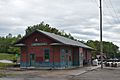
Former Chicago, Burlington, and Quincy station in Bethany

 In Spanish: Bethany (Misuri) para niños
