Eagleville, Missouri facts for kids
Quick facts for kids
Eagleville, Missouri
|
|
|---|---|
| Motto(s):
A small town with a big tomorrow!
|
|

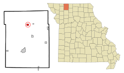
Location of Eagleville, Missouri
|
|
| Country | United States |
| State | Missouri |
| County | Harrison |
| Area | |
| • Total | 1.02 sq mi (2.64 km2) |
| • Land | 1.01 sq mi (2.62 km2) |
| • Water | 0.01 sq mi (0.02 km2) |
| Elevation | 1,096 ft (334 m) |
| Population
(2020)
|
|
| • Total | 275 |
| • Density | 272.28/sq mi (105.13/km2) |
| Time zone | UTC-6 (Central (CST)) |
| • Summer (DST) | UTC-5 (CDT) |
| ZIP code |
64442
|
| Area code(s) | 660 |
| FIPS code | 29-20674 |
| GNIS feature ID | 2396915 |
| Website | http://www.eagleville.com/ |
Eagleville is a small village located in the northern part of Harrison County, Missouri, in the United States. In 2020, about 275 people lived there.
Contents
A Look at Eagleville's Past
Eagleville started out with a different name: Eagle. It was first planned and marked out on a map in 1851. A post office opened there in 1853, also called Eagle. Later, in 1881, the name was officially changed to Eagleville.
Where is Eagleville Located?
Eagleville is found on U.S. Route 69. It's just west of I-35, a major highway. The village is about 14 miles north of Bethany, which is the main town in Harrison County. Another small town, Blythedale, is three miles to the east on Missouri Route N.
According to the United States Census Bureau, Eagleville covers a total area of about 1.02 square miles (2.64 square kilometers). Most of this area, about 1.01 square miles (2.62 square kilometers), is land. A very small part, about 0.01 square miles (0.02 square kilometers), is water.
Eagleville's Population Over Time
| Historical population | |||
|---|---|---|---|
| Census | Pop. | %± | |
| 1880 | 453 | — | |
| 1890 | 305 | −32.7% | |
| 1900 | 292 | −4.3% | |
| 1910 | 330 | 13.0% | |
| 1920 | 340 | 3.0% | |
| 1930 | 305 | −10.3% | |
| 1940 | 353 | 15.7% | |
| 1950 | 360 | 2.0% | |
| 1960 | 341 | −5.3% | |
| 1970 | 388 | 13.8% | |
| 1980 | 364 | −6.2% | |
| 1990 | 275 | −24.5% | |
| 2000 | 321 | 16.7% | |
| 2010 | 316 | −1.6% | |
| 2020 | 275 | −13.0% | |
| U.S. Decennial Census | |||
Understanding the 2010 Census Data
In 2010, the village of Eagleville had 316 residents. These people lived in 131 different homes, and 81 of these were families. The village had about 313 people per square mile. There were 149 housing units in total.
Most of the people in Eagleville were White (98.1%). A small number were African American (0.3%), Native American (0.3%), or from two or more racial backgrounds (1.3%). About 1.6% of the population identified as Hispanic or Latino.
Out of the 131 homes, about 30.5% had children under 18 living there. More than half (51.1%) were married couples living together. About 7.6% of homes had a female head of household without a husband, and 3.1% had a male head of household without a wife. About 38.2% of the homes were not families.
Around 32.1% of all homes had only one person living in them. About 16.1% of homes had someone living alone who was 65 years old or older. On average, each home had about 2.41 people, and each family had about 3.10 people.
The average age of people in Eagleville in 2010 was 40 years old. About 27.8% of residents were under 18. About 5.7% were between 18 and 24 years old. People aged 25 to 44 made up 23.5% of the population. Those aged 45 to 64 were 19.7%, and 23.4% were 65 years or older. Slightly more than half of the residents were female (52.2%), while 47.8% were male.
See also
 In Spanish: Eagleville (Misuri) para niños
 | Anna J. Cooper |
 | Mary McLeod Bethune |
 | Lillie Mae Bradford |

