Wayne County, Iowa facts for kids
Quick facts for kids
Wayne County
|
|
|---|---|

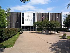
Wayne County Courthouse
|
|

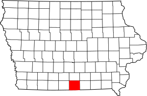
Location within the U.S. state of Iowa
|
|
 Iowa's location within the U.S. |
|
| Country | |
| State | |
| Founded | 1846 |
| Named for | Anthony Wayne |
| Seat | Corydon |
| Largest city | Corydon |
| Area | |
| • Total | 527 sq mi (1,360 km2) |
| • Land | 525 sq mi (1,360 km2) |
| • Water | 1.7 sq mi (4 km2) 0.3% |
| Population
(2020)
|
|
| • Total | 6,497 |
| • Estimate
(2023)
|
6,557 |
| • Density | 12.328/sq mi (4.760/km2) |
| Time zone | UTC−6 (Central) |
| • Summer (DST) | UTC−5 (CDT) |
| Congressional district | 2nd |
Wayne County is a county located in the state of Iowa, USA. It is named after General Anthony Wayne. In 2020, about 6,497 people lived here. This makes it one of the least populated counties in Iowa. The main town and county seat is Corydon.
Contents
History of Wayne County
Wayne County was officially created in 1846. However, it was still connected to other counties for government tasks at first. It was named in honor of General Anthony Wayne, a hero from American history.
The southern border of the county, which touches Missouri, was not clear for some time. In 1848, the US Supreme Court helped decide where the border should be. This border is not a perfectly straight line from east to west. Because of this, Wayne County is not shaped like a perfect rectangle.
Some people started settling in this area as early as 1841. They thought they were in Missouri. But the first settlers who knew they were in Iowa arrived around 1848. The county's government was fully set up in 1851. That's also when Corydon was chosen as the county seat.
Geography and Location
Wayne County covers a total area of about 527 square miles. Most of this area, about 525 square miles, is land. A small part, about 1.7 square miles, is water.
Main Roads in Wayne County
Neighboring Counties
Wayne County shares its borders with several other counties:
- Lucas County (to the north)
- Appanoose County (to the east)
- Putnam County, Missouri (to the southeast)
- Mercer County, Missouri (to the southwest)
- Decatur County (to the west)
Population and People
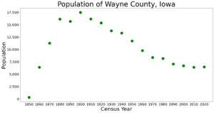
| Historical population | |||
|---|---|---|---|
| Census | Pop. | %± | |
| 1850 | 340 | — | |
| 1860 | 6,409 | 1,785.0% | |
| 1870 | 11,287 | 76.1% | |
| 1880 | 16,127 | 42.9% | |
| 1890 | 15,670 | −2.8% | |
| 1900 | 17,491 | 11.6% | |
| 1910 | 16,184 | −7.5% | |
| 1920 | 15,378 | −5.0% | |
| 1930 | 13,787 | −10.3% | |
| 1940 | 13,308 | −3.5% | |
| 1950 | 11,737 | −11.8% | |
| 1960 | 9,800 | −16.5% | |
| 1970 | 8,405 | −14.2% | |
| 1980 | 8,199 | −2.5% | |
| 1990 | 7,067 | −13.8% | |
| 2000 | 6,730 | −4.8% | |
| 2010 | 6,403 | −4.9% | |
| 2020 | 6,495 | 1.4% | |
| 2023 (est.) | 6,557 | 2.4% | |
| U.S. Decennial Census 1790-1960 1900-1990 1990-2000 2010-2018 |
|||
What the 2020 Census Shows
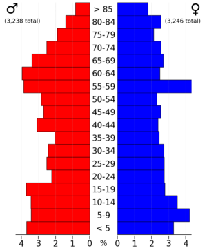
The 2020 census counted 6,497 people living in Wayne County. This means there were about 12 people per square mile. Most people, about 97.38%, said they belonged to one race. About 95.43% were non-Hispanic White. Other groups included Black, Hispanic, Native American, and Asian people.
There were 3,025 homes in the county. Of these, 2,585 were lived in.
What the 2010 Census Showed
The 2010 census recorded 6,403 people in Wayne County. The population density was about 12 people per square mile. There were 3,212 homes, and 2,652 of them were occupied.

Religious Groups in Wayne County
Religious groups in Wayne County, according to ARDA (2020) Mainline Protestant Churches (18.4%) Anabaptist Churches (Amish) (14.8%) Evangelical Churches (11.4%) Catholic Church (0.9%) None* (54.5%)
*"Nones" refers to people who don't identify with a specific religion. However, many of these individuals still believe in a higher power or have spiritual beliefs. They might not attend church regularly.
Towns and Communities
Cities in Wayne County
Unincorporated Communities
These are smaller places that do not have their own city government.
- Cambria
- Confidence
- Harvard
- New York
- Sewal
Ghost Town
Townships in Wayne County
Townships are smaller areas within a county, often used for local administration.
- Benton
- Clay
- Clinton
- Corydon
- Grand River
- Howard
- Jackson
- Jefferson
- Monroe
- Richman
- South Fork
- Union
- Walnut
- Warren
- Washington
- Wright
City Population Ranking (2020)
This table shows the population of cities in Wayne County based on the 2020 census.
† county seat
| Rank | City/Town/etc. | Municipal type | Population (2020 Census) |
|---|---|---|---|
| 1 | † Corydon | City | 1,526 |
| 2 | Seymour | City | 634 |
| 3 | Humeston | City | 465 |
| 4 | Allerton | City | 430 |
| 5 | Lineville | City | 195 |
| 6 | Promise City | City | 88 |
| 7 | Clio | City | 67 |
| 8 | Millerton | City | 36 |
See also
 In Spanish: Condado de Wayne (Iowa) para niños
 | Dorothy Vaughan |
 | Charles Henry Turner |
 | Hildrus Poindexter |
 | Henry Cecil McBay |


