Union County, Iowa facts for kids
Quick facts for kids
Union County
|
|
|---|---|
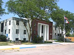
Union County Courthouse
|
|
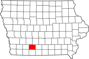
Location within the U.S. state of Iowa
|
|
 Iowa's location within the U.S. |
|
| Country | |
| State | |
| Founded | January 15, 1851 |
| Seat | Creston |
| Largest city | Creston |
| Area | |
| • Total | 426 sq mi (1,100 km2) |
| • Land | 424 sq mi (1,100 km2) |
| • Water | 2.2 sq mi (6 km2) 0.5% |
| Population
(2020)
|
|
| • Total | 12,138 |
| • Density | 28.49/sq mi (11.001/km2) |
| Time zone | UTC−6 (Central) |
| • Summer (DST) | UTC−5 (CDT) |
| Congressional district | 3rd |
Union County is a county in southern Iowa. In 2020, about 12,138 people lived there. The main city and county seat is Creston.
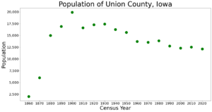
The county was formed in 1853. It was named "Union" because people wanted to keep the United States together. This was a time of disagreement before the American Civil War. Union County had its largest population in 1900. Today, its economy mainly relies on farming and related businesses.
Contents
History of Union County
The first permanent settlers from Europe and America arrived in Union County around 1849 and 1850. Before them, Mormons had a stop called Mt. Pisgah. This was a resting place for Mormon pioneers traveling west. The Mormons left the area by 1848.
Later settlers used Mt. Pisgah as a base. They started farms along the Grand and Platte rivers. These rivers flow through the county. Farmers sold their crops to people traveling to California. Many were going there for the California Gold Rush. Travelers often stayed with the settlers. In 1851, one settler saw 2,600 wagons heading to California. People often brought sheep and cattle, hoping to sell them to miners.
The first village in the county was Petersville. It was founded in 1853, the same year the county was officially created. The county was named to show the desire for the "union" of states to stay strong.
Railroads and Growth
After the American Civil War, railroads were built in the county. This connected towns and helped farmers sell their goods. In 1868, the railroad reached Afton, Iowa. The next year, Creston became a major railroad hub. The railroad built repair shops and other buildings there.
The railroad brought many new people to the area. Immigrants came from Europe, and others moved from eastern U.S. states. They were drawn by the rich farmland. The Burlington Northern Santa Fe Railroad (BNSF) is still important today. It mainly carries grain and coal.
The Bluegrass Palace
Union County has a fair every year. In the late 1800s, this part of Iowa was known for its bluegrass. In 1889, the Bluegrass Association was started. It included representatives from 18 counties.
They built a special building called the Bluegrass Palace. It was located at the Union County Fairgrounds. The palace was designed by Louis Syberkro and built by J. C. Woodruff, both from Creston. It was made of sod and hay bales over a wood frame. The building was 100 feet wide and had a tall central tower. Inside, it showed off farm products and natural resources from the area. These included wood, coal, and stone.
The first palace was very popular. So, the next year, they built an even bigger one. It had three times more space. It also had a separate auditorium that could hold 2,000 people.
Geography of Union County
The U.S. Census Bureau says Union County covers about 426 square miles. Most of this is land, with a small amount of water.
Major Highways
- U.S. Highway 34
- U.S. Highway 169
- Iowa Highway 25
Neighboring Counties
- Adair County (to the northwest)
- Madison County (to the northeast)
- Clarke County (to the east)
- Ringgold County (to the south)
- Adams County (to the west)
Population Information
| Historical population | |||
|---|---|---|---|
| Census | Pop. | %± | |
| 1860 | 2,012 | — | |
| 1870 | 5,986 | 197.5% | |
| 1880 | 14,980 | 150.3% | |
| 1890 | 16,900 | 12.8% | |
| 1900 | 19,928 | 17.9% | |
| 1910 | 16,616 | −16.6% | |
| 1920 | 17,268 | 3.9% | |
| 1930 | 17,435 | 1.0% | |
| 1940 | 16,280 | −6.6% | |
| 1950 | 15,651 | −3.9% | |
| 1960 | 13,712 | −12.4% | |
| 1970 | 13,557 | −1.1% | |
| 1980 | 13,858 | 2.2% | |
| 1990 | 12,750 | −8.0% | |
| 2000 | 12,309 | −3.5% | |
| 2010 | 12,534 | 1.8% | |
| 2020 | 12,138 | −3.2% | |
| 2023 (est.) | 11,906 | −5.0% | |
| U.S. Decennial Census 1790-1960 1900-1990 1990-2000 2010-2018 |
|||
2020 Census Details
In 2020, the county had 12,138 people. This means there were about 28 people per square mile. Most people (96.37%) reported being of one race. About 90.34% were non-Hispanic White. There were also smaller groups of Black, Hispanic, Native American, and Asian people.
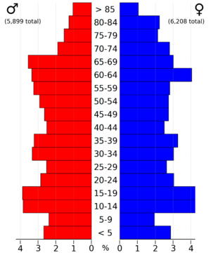
2010 Census Details
In 2010, the population was 12,534. There were about 29 people per square mile. The county had 5,937 housing units, and 5,271 of them were lived in.
Communities in Union County
Cities
Unincorporated Communities
- Talmage
Townships
- Dodge
- Douglas
- Grant
- Highland
- Jones
- Lincoln
- New Hope
- Platte
- Pleasant
- Sand Creek
- Spaulding
- Union
Census-Designated Place
Population Ranking of Communities
The table below shows the population of cities and towns in Union County, based on the 2020 census.
† county seat
| Rank | City/Town/etc. | Type | Population (2020 Census) |
|---|---|---|---|
| 1 | † Creston | City | 7,536 |
| 2 | Afton | City | 874 |
| 3 | Lorimor | City | 386 |
| 4 | Cromwell | City | 105 |
| 5 | Arispe | City | 96 |
| 6 | Shannon City (partially in Ringgold County) | City | 67 (73 total) |
| 7 | Thayer | City | 51 |
| 8 | Kent | CDP | 37 |
Education
Here are the school districts in Union County:
- Creston Community School District
- East Union Community School District
- Lenox Community School District
- Murray Community School District
- Orient-Macksburg Community School District
See also
 In Spanish: Condado de Union (Iowa) para niños
 | Ernest Everett Just |
 | Mary Jackson |
 | Emmett Chappelle |
 | Marie Maynard Daly |


