Platte River facts for kids
Quick facts for kids Platte River |
|
|---|---|

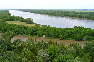
Platte River at Mahoney State Park
|
|

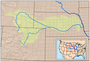
Map showing the Platte River watershed, including the North Platte and South Platte tributaries
|
|
| Other name(s) | Nebraska River, Shallow River, Ñíbraxge (iow), Pȟaŋkéska Wakpá (lkt), Ní Btháska (oma), Kíckatus (paw) |
| Country | United States |
| State | Nebraska |
| Region | Great Plains |
| Cities | North Platte, Kearney, Grand Island, Fremont, Omaha |
| Physical characteristics | |
| Main source | North Platte River Confluence of Grizzly Creek and Little Grizzly Creek, Jackson County, Colorado 8,050 ft (2,450 m) 40°38′23″N 106°24′19″W / 40.63972°N 106.40528°W |
| 2nd source | South Platte River Confluence of Middle Fork and South Fork South Platte Rivers, Park County, Colorado 8,785 ft (2,678 m) 39°00′40″N 105°44′25″W / 39.01111°N 105.74028°W |
| River mouth | Missouri River Cass / Sarpy counties, at Plattsmouth, Nebraska 942 ft (287 m) 41°03′14″N 95°52′53″W / 41.05389°N 95.88139°W |
| Length | 310 mi (500 km), West-east |
| Basin features | |
| River system | Missouri River basin |
| Basin size | 84,910 sq mi (219,900 km2) |
| Tributaries |
|
The Platte River is a major river in the state of Nebraska, USA. It is about 310 miles (500 km) long. If you measure it from its farthest starting point, including its main branch, the North Platte River, it flows for over 1,050 miles (1,690 km)! The Platte River is a tributary of the Missouri River. The Missouri River then flows into the Mississippi River, which finally reaches the Gulf of Mexico.
For most of its length, the Platte River is wide, shallow, and often muddy. It has many islands and a swampy bottom. It looks like a "braided stream" because it splits into many smaller channels that rejoin. Because of these features, it was too hard for early explorers to travel on it by canoe. This means it was never a main route for European-American trappers or explorers.
The Platte River system is very important because it drains a huge area. This includes a big part of the central Great Plains in Nebraska. It also drains the eastern Rocky Mountains in Colorado and Wyoming. The river valley was a key route for people moving west in the United States. Famous trails like the Oregon, California, Mormon, and Bozeman trails all followed the Platte River.
French explorers and fur trappers were the first Europeans to see the Platte River around 1714. They first called it "Nebraskier" (Nebraska). This name came from the Otoe people's name for it, meaning "flat water." This is very similar to the French words "rivière plate," meaning "flat river." This is probably where the name "Platte River" comes from!
Images for kids
-
Platte River near Ft. Kearny State Historical Site in Central Nebraska
-
Encampment Along The Platte by Worthington Whittredge
-
Every year hundreds of thousands of sandhill cranes congregate on the Platte River during their spring migration, forming large flocks that use the sandbars of the Platte River as a nighttime refuge before dispersing to local fields to feed during the day.
-
A great blue heron and immature bald eagle on the Platte River in Nebraska
See also
 In Spanish: Río Platte para niños
 | Audre Lorde |
 | John Berry Meachum |
 | Ferdinand Lee Barnett |


