North Platte River facts for kids
Quick facts for kids North Platte |
|
|---|---|

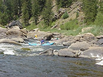
Canoers on the North Platte River near the Colorado - Wyoming border in Northgate Canyon
|
|

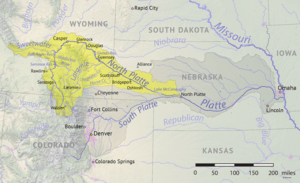
North Platte River watershed and course
|
|
| Country | United States |
| State | Colorado, Wyoming, Nebraska |
| Cities | Walden, CO, Casper, WY, Scottsbluff, NE, Oshkosh, NE, North Platte, NE |
| Physical characteristics | |
| Main source | Confluence of Grizzly and Little Grizzly Creeks in Colorado Jackson County, Colorado 8,060 ft (2,460 m) 40°33′01″N 106°23′35″W / 40.550331°N 106.392975°W |
| River mouth | Platte River Lincoln County, Nebraska 2,762 ft (842 m) 41°06′56″N 100°41′15″W / 41.115573°N 100.687637°W |
| Length | 716 mi (1,152 km) |
| Basin features | |
| Basin size | 30,900 sq mi (80,000 km2) |
| Tributaries |
|
The North Platte River is a very important river in the western United States. It is about 716 miles (1,152 km) (1,152 km) long. This river flows through three states: Colorado, Wyoming, and Nebraska. It is a major branch of the Platte River.
The North Platte River starts high in the Rocky Mountains of Jackson County, Colorado. This area is called North Park (Colorado basin). Many small streams from tall mountains, some over 11,000 feet (3,400 m) (3,353 m) high, feed the river. From Colorado, the river flows north into Wyoming. It then turns east-southeast.
The North Platte River joins the South Platte River in western Nebraska. Together, they form the main Platte River. The Platte River then flows into the Missouri River, which eventually joins the Mississippi River. This huge river system finally reaches the Gulf of Mexico. The North Platte River helps drain a large area of northern Colorado, eastern Wyoming, and western Nebraska. You can enjoy canoeing, kayaking, and rafting on parts of the river when the water is high.
Contents
A Historic Trail West
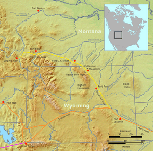
For many years, the North Platte River valley was a very important path for people traveling west in the United States. Pioneers needed water and grass for their animals. River valleys, like the North Platte, provided these important things. Many famous trails followed this river. These included the Oregon Trail, California Trail, Mormon Trail, and Bozeman Trail.
Early explorers and fur traders were the first to use this route. In 1811, Wilson Price Hunt wrote about the trail. Later, in 1823, Jedediah Smith and other trappers rediscovered it. By the 1830s, fur traders had made the path into a rough wagon trail. This allowed wagons to travel from the Missouri River all the way to the Green River in Wyoming.
From the 1840s to the 1860s, thousands of pioneers used these trails. They were heading to new lands in Oregon, California, and Utah. The trails often followed the North Platte River closely. Sometimes, they had to leave the river to find easier paths through the rugged land. Near what is now Casper, Wyoming, pioneers often crossed the river using ferries. Later, bridges were built to help them cross.
The River's Journey
The North Platte River begins in Jackson County, Colorado. This area is a valley surrounded by tall mountains. Many small streams flow into the river from these mountains. These streams are fed by melting snow. The river then flows north into Wyoming. Here, it passes through Northgate Canyon, a popular spot for rafting.
In Colorado and Wyoming, the river is narrower and flows much faster. It's a great place for outdoor activities like rafting and fly fishing. Many people come to catch rainbow trout and other sport fish. As the river moves into western Nebraska, it changes. It becomes wider, shallower, and flows more slowly. This part of the river is like a green oasis in a drier area.
Dams and Reservoirs
The North Platte River has several dams along its path. These dams create large lakes called reservoirs. These reservoirs are important for storing water and for recreation.
- The Seminoe Dam creates the Seminoe Reservoir.
- Further downstream is the Kortes Reservoir.
- The Pathfinder Dam creates the Pathfinder Reservoir. This is where the Sweetwater River joins the North Platte.
- Near Casper, Wyoming, the river flows through Alcova and Gray Reef reservoirs.
After Casper, the river turns southeast and flows onto the Great Plains. It passes towns like Douglas, Wyoming. It also flows through Glendo and Guernsey Reservoirs. The Laramie River joins the North Platte near the Fort Laramie National Historic Site.
The River in Nebraska
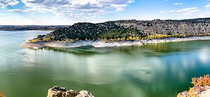
As the North Platte River enters western Nebraska, it flows between the cities of Scottsbluff, Nebraska and Gering, Nebraska. In Keith County, Nebraska, the Kingsley Dam creates Lake C.W. McConaughy. This is the largest reservoir in Nebraska. It's very important for watering farms and for fun activities like boating and swimming. Kingsley Dam is the second-largest hydraulic fill dam in the world.
East of Kingsley Dam, the North Platte River flows almost side-by-side with the South Platte River. They are sometimes only about 5 miles (8 km) apart. Finally, they meet just east of the city of North Platte, Nebraska, to form the main Platte River.
Historically, the North Platte River used to be very wide, sometimes over a mile (1.6 km) across. Today, it is much smaller by the time it reaches places like Paxton, Nebraska. This is because a lot of its water is used for irrigation to help grow crops.
See also
 In Spanish: Río Platte del Norte para niños
 | Laphonza Butler |
 | Daisy Bates |
 | Elizabeth Piper Ensley |


