
Walden, Colorado facts for kids
Quick facts for kids
Walden, Colorado
|
|
|---|---|

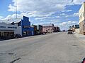
Main Street in Walden, July 2010
|
|

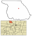
Location of Walden in Jackson County, Colorado.
|
|
| Country | |
| State | |
| County | Jackson County - seat |
| Established | 1889 |
| Incorporated | December 2, 1890 |
| Named for | Marcus Aurelius Walden (former postmaster) |
| Government | |
| • Type | Statutory Town |
| Area | |
| • Total | 0.34 sq mi (0.87 km2) |
| • Land | 0.34 sq mi (0.87 km2) |
| • Water | 0.00 sq mi (0.00 km2) |
| Elevation | 8,098 ft (2,468 m) |
| Population
(2020)
|
|
| • Total | 606 |
| • Density | 1,782/sq mi (697/km2) |
| Time zone | UTC−7 (Mountain (MST)) |
| • Summer (DST) | UTC−6 (MDT) |
| ZIP codes |
80430, 80480
|
| Area code(s) | 970 |
| FIPS code | 08-82130 |
| GNIS feature ID | 2413440 |
Walden is a small town in Colorado, United States. It is the main town and county seat of Jackson County. Walden is located in the middle of a large valley called North Park. People who live in Walden and the nearby areas often call themselves "North Parkers."
In 2020, about 606 people lived in Walden. The town sits very high up, at an elevation of about 8,099 feet (2,468 meters) above sea level. Walden was started in 1889 and officially became a town on December 2, 1890. It was named after Mark A. Walden, who was an early postmaster in the area.
Contents
Exploring Walden's Location and Size
Walden is a small town in terms of its area. It covers about 0.3 square miles (0.8 square kilometers) of land. The town is proud to call itself the "Moose viewing capital of Colorado." This means it's a great place to spot moose in the wild!
Walden's Weather and Climate
Because Walden is so high up, it has a unique climate. It's mostly a semi-arid climate, which means it's quite dry. It's also very close to a subalpine climate, which means it has cold, snowy winters.
Temperature Extremes in Walden
Walden can get very hot and very cold. The hottest temperature ever recorded was 94°F (34°C). This happened on July 6, 1989, August 1, 2000, and July 15, 2002. The coldest temperature ever recorded was a chilly -48°F (-44°C). This extreme cold was noted on January 12, 1963, February 2, 2011, and January 6, 2017.
How Many People Live in Walden?
The population of Walden has changed over the years. Here's a look at how many people have lived there during different census years:
| Historical population | |||
|---|---|---|---|
| Census | Pop. | %± | |
| 1890 | 64 | — | |
| 1900 | 141 | 120.3% | |
| 1910 | 162 | 14.9% | |
| 1920 | 260 | 60.5% | |
| 1930 | 284 | 9.2% | |
| 1940 | 668 | 135.2% | |
| 1950 | 696 | 4.2% | |
| 1960 | 809 | 16.2% | |
| 1970 | 907 | 12.1% | |
| 1980 | 947 | 4.4% | |
| 1990 | 890 | −6.0% | |
| 2000 | 734 | −17.5% | |
| 2010 | 608 | −17.2% | |
| 2020 | 606 | −0.3% | |
| U.S. Decennial Census | |||
Getting Around Walden
Two main state highways pass through Walden:
- State Highway 14
- State Highway 125
There's also a special service called OATS (Older Americans Transport Service). This service helps older adults get to nearby cities like Laramie, Wyoming or Steamboat Springs, CO. It also provides rides to Denver International Airport.
Images for kids
-
Main Street in Walden, July 2010
-
Location of Walden in Jackson County, Colorado.
See also
 In Spanish: Walden (Colorado) para niños
