
Laramie, Wyoming facts for kids
Quick facts for kids
Laramie, Wyoming
|
|
|---|---|

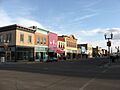
Downtown Laramie Historic District
|
|
| Motto(s):
Gem City of the Plains
|
|

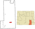
Location in Albany County and the state of Wyoming.
|
|
| Country | United States |
| State | Wyoming |
| County | Albany |
| Government | |
| • Type | Council–manager |
| Area | |
| • City | 18.38 sq mi (47.61 km2) |
| • Land | 18.36 sq mi (47.55 km2) |
| • Water | 0.02 sq mi (0.06 km2) |
| Elevation | 7,165 ft (2,184 m) |
| Population
(2020)
|
|
| • City | 31,407 |
| • Density | 1,781.74/sq mi (701.16/km2) |
| • Metro | 38,943 |
| Time zone | UTC−7 (MST) |
| • Summer (DST) | UTC−6 (MDT) |
| ZIP Code |
82070-82073
|
| Area code | 307 |
| FIPS code | 56-45050 |
| GNIS feature ID | 1590526 |
Laramie (/ˈlærəmi/) is a city in Wyoming, United States. It is the main city of Albany County, Wyoming. Laramie is known for being very high up, about 7,200 feet (2,184 meters) above sea level. It also has a rich history with railroads and is home to the University of Wyoming.
In 2020, about 31,407 people lived in Laramie, making it the fourth biggest city in Wyoming. The city is located on the Laramie River in southeastern Wyoming. It is west of Cheyenne and about 25 miles (40 km) north of the Colorado state line. Laramie is where Interstate 80 and U.S. Route 287 meet.
Native American people lived in this area for over 12,000 years. European Americans settled Laramie in 1868. This happened when the Union Pacific Railroad line reached the area. The Laramie River and nearby creeks with fresh springs made it a good place to live. Today, Laramie is home to the University of Wyoming, WyoTech, and a branch of Laramie County Community College. The Laramie Regional Airport serves the city. You can find the old ruins of Fort Sanders, an army fort older than Laramie, just south of the city. Laramie is located in the Laramie Valley, between the Snowy Range and the Laramie Range. This makes it a great place for outdoor adventures.
Contents
What's in a Name?
Laramie is named after Jacques LaRamie. He was a French or French-Canadian trapper who disappeared in the Laramie Mountains in the early 1820s. He was one of the first Europeans to visit this area. Later, settlers named a river, a mountain range, a peak, a U.S. Army fort, a county, and the city after him. More places in Wyoming are named for him than for any other trapper, except Jim Bridger. Because the name was used so much, the town was called Laramie City for many years to help people tell it apart from other places.
How Laramie Began
The city started in the mid-1860s as a "tent city." It was near the Overland Stage Line route and the Union Pacific Railroad, which was part of the first transcontinental railroad. It was also just north of the Fort Sanders army post.
The railroad tracks reached Laramie on May 4, 1868. The first regular passenger train service began on May 10, 1868. Soon, people started building more permanent stores, houses, a school, and churches. Laramie was famous as the western end of the Union Pacific Railroad for a short time. This changed in August 1868 when more track was opened further west.
In its early days, the frontier town had some problems with law and order. Its first mayor, M. C. Brown, resigned in June 1868. This was because of issues with a group of half-brothers, including "Big" Steve Long. Long was Laramie's first marshal and owned a saloon. He and his brothers caused trouble for settlers.
To fix this, the first Albany County sheriff, N. K. Boswell, started a "Vigilance Committee." This group helped to bring law and order to the town.

By the end of the 1860s, Laramie became an important center for the new Wyoming Territory. In 1869, Wyoming's first government passed a law giving women equal political rights. In March 1870, five women from Laramie became the first women in the world to serve on a jury. Also, on September 6, 1870, Laramie resident Louisa Swain was the first woman in the United States to legally vote in a general election.
Early businesses in Laramie included railroad yards, brick making, and a brewery. In 1886, a plant was built to produce electricity. Several regional railroads were also based in Laramie.
The University of Wyoming (UW) was started in 1886 by Governor Francis E. Warren. Laramie was chosen as its location, and UW opened in 1887. It is the only public university in the state.
Laramie Today
In 2004, Laramie was the first city in Wyoming to pass a law against smoking in indoor workplaces. This included bars, restaurants, and private clubs. Some people tried to get the law removed, but voters decided to keep it. The law went into effect in April 2005.

Geography and Climate
Laramie is located on a high plain between two mountain ranges. To the west, about 30 miles (48 km) away, is the Snowy Range. To the east, about 7 miles (11 km) away, is the Laramie Range. The city is about 7,165 feet (2,184 meters) above sea level. The Laramie River flows through the city.
Laramie is about 50 miles (80 km) west of Cheyenne. It is also about 130 miles (209 km) north of Denver, Colorado. Laramie is along U.S. Route 30, Interstate 80, and U.S. Route 287. It is still an important stop on the Union Pacific Railroad line.
Weather in Laramie
Laramie has a semi-arid climate. This means it has long, cold, and dry winters. Summers are short, warm, and a bit wetter.
On average, Laramie gets about 11 inches (280 mm) of rain each year. It rains about 86 days a year. The temperature reaches 90°F (32°C) or warmer only a couple of times a year. In December, the average temperature is about 21.1°F (-6.1°C). In July, it's about 64.0°F (17.8°C). The city gets about 48 inches (122 cm) of snow each year. Because it's so high up, winters are long, and summers are short and cool. The time for growing plants is short, usually from early June to mid-September.
| Climate data for Laramie, Wyoming (Laramie Regional Airport), 1991–2020 normals, extremes 1892–present | |||||||||||||
|---|---|---|---|---|---|---|---|---|---|---|---|---|---|
| Month | Jan | Feb | Mar | Apr | May | Jun | Jul | Aug | Sep | Oct | Nov | Dec | Year |
| Record high °F (°C) | 60 (16) |
63 (17) |
71 (22) |
77 (25) |
87 (31) |
94 (34) |
96 (36) |
94 (34) |
91 (33) |
87 (31) |
70 (21) |
62 (17) |
94 (34) |
| Mean maximum °F (°C) | 49.6 (9.8) |
52.1 (11.2) |
62.1 (16.7) |
69.7 (20.9) |
78.2 (25.7) |
86.5 (30.3) |
89.7 (32.1) |
87.2 (30.7) |
83.4 (28.6) |
73.6 (23.1) |
61.1 (16.2) |
51.1 (10.6) |
90.1 (32.3) |
| Mean daily maximum °F (°C) | 33.4 (0.8) |
35.6 (2.0) |
44.5 (6.9) |
51.2 (10.7) |
61.5 (16.4) |
73.9 (23.3) |
81.1 (27.3) |
79.0 (26.1) |
70.2 (21.2) |
56.0 (13.3) |
42.5 (5.8) |
32.7 (0.4) |
55.1 (12.8) |
| Daily mean °F (°C) | 21.9 (−5.6) |
23.8 (−4.6) |
31.8 (−0.1) |
37.9 (3.3) |
47.5 (8.6) |
58.0 (14.4) |
64.8 (18.2) |
62.8 (17.1) |
54.3 (12.4) |
41.9 (5.5) |
30.2 (−1.0) |
21.5 (−5.8) |
41.4 (5.2) |
| Mean daily minimum °F (°C) | 10.3 (−12.1) |
12.1 (−11.1) |
19.2 (−7.1) |
24.5 (−4.2) |
33.4 (0.8) |
42.0 (5.6) |
48.5 (9.2) |
46.5 (8.1) |
38.5 (3.6) |
27.8 (−2.3) |
18.0 (−7.8) |
10.2 (−12.1) |
27.6 (−2.4) |
| Mean minimum °F (°C) | −15.0 (−26.1) |
−12.2 (−24.6) |
−2.3 (−19.1) |
7.5 (−13.6) |
18.8 (−7.3) |
31.9 (−0.1) |
39.5 (4.2) |
37.8 (3.2) |
25.1 (−3.8) |
5.3 (−14.8) |
−7.4 (−21.9) |
−17.0 (−27.2) |
−24.4 (−31.3) |
| Record low °F (°C) | −50 (−46) |
−42 (−41) |
−35 (−37) |
−14 (−26) |
5 (−15) |
22 (−6) |
30 (−1) |
27 (−3) |
−2 (−19) |
−26 (−32) |
−26 (−32) |
−34 (−37) |
−50 (−46) |
| Average precipitation inches (mm) | 0.28 (7.1) |
0.32 (8.1) |
0.48 (12) |
1.04 (26) |
1.75 (44) |
1.49 (38) |
1.34 (34) |
1.14 (29) |
1.11 (28) |
0.83 (21) |
0.42 (11) |
0.32 (8.1) |
10.52 (267) |
| Average snowfall inches (cm) | 4.6 (12) |
5.9 (15) |
8.4 (21) |
8.3 (21) |
3.5 (8.9) |
0.2 (0.51) |
0.0 (0.0) |
0.0 (0.0) |
0.8 (2.0) |
3.3 (8.4) |
7.7 (20) |
7.0 (18) |
49.7 (126) |
| Average precipitation days (≥ 0.01 in) | 4.4 | 5.1 | 5.9 | 8.6 | 11.3 | 8.4 | 9.3 | 9.4 | 7.3 | 6.3 | 5.1 | 4.9 | 86.0 |
| Average snowy days (≥ 0.1 in) | 5.2 | 5.5 | 6.1 | 5.6 | 2.3 | 0.2 | 0.0 | 0.0 | 0.8 | 2.6 | 6.0 | 5.5 | 39.6 |
| Source: NOAA (snow 1981–2010) | |||||||||||||
| Climate data for Laramie 2 NW, Wyoming, 1991–2020 normals, extremes 1966–present | |||||||||||||
|---|---|---|---|---|---|---|---|---|---|---|---|---|---|
| Month | Jan | Feb | Mar | Apr | May | Jun | Jul | Aug | Sep | Oct | Nov | Dec | Year |
| Record high °F (°C) | 62 (17) |
68 (20) |
72 (22) |
78 (26) |
88 (31) |
94 (34) |
97 (36) |
97 (36) |
92 (33) |
85 (29) |
72 (22) |
63 (17) |
97 (36) |
| Mean maximum °F (°C) | 50.5 (10.3) |
52.9 (11.6) |
62.5 (16.9) |
70.4 (21.3) |
78.5 (25.8) |
86.0 (30.0) |
90.8 (32.7) |
88.9 (31.6) |
84.4 (29.1) |
75.2 (24.0) |
62.1 (16.7) |
51.8 (11.0) |
91.3 (32.9) |
| Mean daily maximum °F (°C) | 33.6 (0.9) |
36.1 (2.3) |
45.0 (7.2) |
51.2 (10.7) |
61.6 (16.4) |
73.0 (22.8) |
80.7 (27.1) |
78.8 (26.0) |
70.5 (21.4) |
56.5 (13.6) |
43.0 (6.1) |
33.0 (0.6) |
55.3 (12.9) |
| Daily mean °F (°C) | 20.9 (−6.2) |
23.4 (−4.8) |
31.6 (−0.2) |
37.7 (3.2) |
47.4 (8.6) |
57.3 (14.1) |
63.7 (17.6) |
61.3 (16.3) |
52.8 (11.6) |
41.1 (5.1) |
29.9 (−1.2) |
20.3 (−6.5) |
40.6 (4.8) |
| Mean daily minimum °F (°C) | 8.2 (−13.2) |
10.7 (−11.8) |
18.1 (−7.7) |
24.1 (−4.4) |
33.3 (0.7) |
41.6 (5.3) |
46.8 (8.2) |
43.8 (6.6) |
35.1 (1.7) |
25.7 (−3.5) |
16.8 (−8.4) |
7.7 (−13.5) |
26.0 (−3.3) |
| Mean minimum °F (°C) | −15.9 (−26.6) |
−13.9 (−25.5) |
−2.5 (−19.2) |
6.8 (−14.0) |
19.3 (−7.1) |
31.5 (−0.3) |
38.5 (3.6) |
34.5 (1.4) |
23.2 (−4.9) |
7.8 (−13.4) |
−7.3 (−21.8) |
−17.9 (−27.7) |
−25.3 (−31.8) |
| Record low °F (°C) | −43 (−42) |
−40 (−40) |
−27 (−33) |
−18 (−28) |
7 (−14) |
20 (−7) |
30 (−1) |
26 (−3) |
5 (−15) |
−24 (−31) |
−28 (−33) |
−40 (−40) |
−43 (−42) |
| Average precipitation inches (mm) | 0.31 (7.9) |
0.35 (8.9) |
0.60 (15) |
1.16 (29) |
1.81 (46) |
1.44 (37) |
1.41 (36) |
1.02 (26) |
1.03 (26) |
0.95 (24) |
0.45 (11) |
0.39 (9.9) |
10.92 (276.7) |
| Average precipitation days (≥ 0.01 in) | 5.3 | 6.1 | 6.9 | 9.7 | 11.4 | 8.5 | 9.3 | 8.8 | 7.6 | 7.3 | 6.0 | 5.4 | 92.3 |
| Source 1: NOAA | |||||||||||||
| Source 2: XMACIS2 | |||||||||||||
People of Laramie
| Historical population | |||
|---|---|---|---|
| Census | Pop. | %± | |
| 1870 | 828 | — | |
| 1880 | 2,696 | 225.6% | |
| 1890 | 6,388 | 136.9% | |
| 1900 | 8,207 | 28.5% | |
| 1910 | 8,237 | 0.4% | |
| 1920 | 8,301 | 0.8% | |
| 1930 | 8,609 | 3.7% | |
| 1940 | 10,627 | 23.4% | |
| 1950 | 15,581 | 46.6% | |
| 1960 | 17,520 | 12.4% | |
| 1970 | 23,143 | 32.1% | |
| 1980 | 24,410 | 5.5% | |
| 1990 | 26,687 | 9.3% | |
| 2000 | 27,204 | 1.9% | |
| 2010 | 30,816 | 13.3% | |
| 2020 | 31,407 | 1.9% | |
| source: | |||
In 2010, Laramie had 30,816 people living in 13,394 households. About 20.4% of households had children under 18. The average age in the city was 25.4 years old. Many residents were students, especially those aged 18 to 24.
Fun Things to Do
Yearly Events

Laramie Jubilee Days started in 1940. It celebrates Wyoming Statehood Day, which is on July 10. Now, Jubilee Days lasts for several days around the Fourth of July. You can usually find food, live music, games, carnival rides, a street fair, a parade, a softball tournament, and rodeo events.
Museums and Music
The Geological Museum at the University of Wyoming is open to everyone. It has over 50,000 rocks, minerals, and fossils, including a dinosaur exhibit. The university's art museum has art shows, talks, and workshops all year. The Fine Arts Concert Hall on campus often has concerts during the school year.
The Laramie Plains Museum is located in the historic Ivinson Mansion. The Wyoming Children's Museum and Nature Center offers fun, hands-on exhibits and pottery classes for kids aged three and up. In 2012, the Wyoming House for Historic Women opened in downtown Laramie.
Libraries for Learning
The main library for Albany County is near downtown Laramie. It has many books and materials for both adults and children. There are also smaller branch libraries in Centennial and Rock River.
The William Robertson Coe Library is the main library at the University of Wyoming. It has resources for many subjects like business, science, and history. The university also has special libraries for geology and law. The American Heritage Center stores old books and important historical papers.
Historic Places to Visit

Twenty-one places in Laramie are listed on the National Register of Historic Places. This means they are important historical sites. One of these is the Wyoming Territorial Penitentiary. This site shows what a frontier community was like in the late 1800s.
Other important sites include the Downtown Laramie Historic District and Old Main at the University of Wyoming. There are also several historic homes and ranches.
Two other important sites near Laramie are also on the National Register. About 20 miles (32 km) east of the city is the Ames Monument. This is a large granite pyramid built to honor two brothers who helped build the Union Pacific Railroad. The other site is Como Bluff. This ridge has rock formations with fossils, including dinosaurs, from the Late Jurassic period.
Sports and Outdoor Activities
College Sports
The University of Wyoming has sports teams called the Wyoming Cowboys. They compete in NCAA Division I sports. UW has 17 official sports teams, including basketball, football, soccer, and track and field.
Outdoor Adventures
Laramie is a great place for outdoor sports. It is located between the Laramie Range and the Snowy Range. Popular activities include skiing, snowmobiling, mountain biking, hunting, fishing, and hiking.
Vedauwoo is a popular spot for rock climbing, hiking, and camping. It has many weathered granite rocks and cliffs. It is about 16 miles (26 km) east of Laramie.
In winter, you can go cross-country skiing on groomed trails in the Laramie Range. The Snowy Range also has cross-country trails. Many areas are open for snowshoeing. The Snowy Range Ski Area offers downhill skiing and snowboarding on 27 trails. It is about 30 miles (48 km) west of Laramie.
Laramie is also a hub for mountain biking. There are many trails in the Laramie Range and Snowy Range. The Medicine Bow Rail–Trail is a 21-mile (34 km) long mountain bike trail. It was built on an old railroad bed southwest of Laramie. The Laramie Enduro 111K is a long mountain bike race held every year.
Other events include the Poker Run ski race in February and the Tour De Laramie bicycle rally in May. The Wyoming Marathon Races are held every year in the Medicine Bow National Forest.
Fishing for trout is also popular in the Laramie River and other streams and lakes. You can also enjoy camping, picnicking, and rafting on the Laramie River. Many people enjoy seeing wildlife like deer, elk, and moose. The Highway 130 road through the Snowy Range is a beautiful scenic drive.
Parks and Recreation
Laramie has 14 city parks. Residents can also use the University of Wyoming's 18-hole golf course and other university recreation spots. The Community Recreation Center has swimming pools and other facilities. The Community Ice Arena is open to everyone for ice skating.
Education in Laramie
Albany County School District#1 is based in Laramie. It runs 19 public schools for about 4,000 students. In Laramie, there are seven elementary schools, one middle school, Laramie High School, and Whiting High School. Snowy Range Academy is a charter school for children in kindergarten through 7th grade. The University of Wyoming also has a Lab School for K–9 students.
The main campus of the University of Wyoming is in Laramie. In 2009, about 13,400 students were enrolled there. A branch of Laramie County Community College is also in Laramie.
The WyoTech campus offers 9-month courses. These include Automotive Technology, Collision & Refinishing Technology, and Diesel Technology. They also have special programs like High-Performance Power Trains.
Media and News
The Laramie Boomerang is Laramie's main newspaper. The Branding Iron is a newspaper run by students at the University of Wyoming. Wyoming Public Television has a transmitter near Laramie. Many radio stations also broadcast from Laramie.
Getting Around Laramie
Main Roads
 I-80 This major highway runs from California to New Jersey. It crosses US 287 in Laramie.
 US 30 (Lincoln Highway)
 US 287 (Yellowstone Highway)
 WYO 130 (Snowy Range Road)
Airport Travel
SkyWest Airlines offers daily flights between Laramie Regional Airport and Denver, Colorado. The airport is about 3 miles (5 km) west of downtown. It is used by commercial flights, private planes, and university research aircraft.
Ground Transportation
The University of Wyoming Transit System provides bus service in the city. It is mainly for students but is open to everyone. Laramie also has taxi companies and Uber service.
For travel between cities, Laramie is served by Greyhound Lines. You can also take Green Ride of Northern Colorado to Fort Collins and Denver International Airport.
Laramie used to have passenger train service from the Union Pacific. Now, only bus service is available through Amtrak Thruway. The old Union Pacific passenger depot in Laramie is now a small museum and a place for community events.
Famous People from Laramie
- Thurman Arnold (1891–1969), a lawyer.
- Jim Beaver (born 1950), an actor and writer.
- Jaycee Carroll (born 1983), a basketball player.
- Robert Eggers (born 1983), a film director.
- Grace Raymond Hebard (1861–1936), a Wyoming historian and educator.
- Cody Lundin (born 1967), a survival instructor.
- Edgar Wilson Nye (1850–1896), a humorist who lived in Laramie.
- Ken Sailors (1921–2016), a basketball player who invented the jump shot. He led the University of Wyoming Cowboys to win the NCAA Men's Basketball Championship in 1943.
- Gerry Spence (born 1929), a trial lawyer.
- Jamila Wideman (born 1975), a basketball player and lawyer.
Images for kids
-
Downtown Laramie Historic District
-
Location of Laramie in Albany County and Wyoming
-
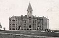
"Old Main" building at the University of Wyoming in Laramie, 1908
-
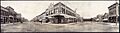
Laramie, 1908
-
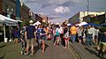
Laramie Jubilee, 2016
-
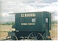
Marshal's carriage at Wyoming Territorial Prison
See also
 In Spanish: Laramie (Wyoming) para niños
