Albany County, Wyoming facts for kids
Quick facts for kids
Albany County
|
||
|---|---|---|
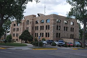
Albany County Courthouse
|
||
|
||
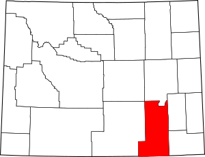
Location within the U.S. state of Wyoming
|
||
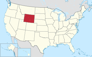 Wyoming's location within the U.S. |
||
| Country | ||
| State | ||
| Founded | December 16, 1868 | |
| Named for | Albany, New York | |
| Seat | Laramie | |
| Largest city | Laramie | |
| Area | ||
| • Total | 4,309 sq mi (11,160 km2) | |
| • Land | 4,274 sq mi (11,070 km2) | |
| • Water | 35 sq mi (90 km2) 0.8% | |
| Population
(2020)
|
||
| • Total | 37,066 | |
| • Density | 8.6020/sq mi (3.3212/km2) | |
| Time zone | UTC−7 (Mountain) | |
| • Summer (DST) | UTC−6 (MDT) | |
| Congressional district | At-large | |
Albany County (![]() i/ˈɔːlbəni/ awl-BƏ-nee) is a county in the U.S. state of Wyoming. In 2020, about 37,066 people lived there.
i/ˈɔːlbəni/ awl-BƏ-nee) is a county in the U.S. state of Wyoming. In 2020, about 37,066 people lived there.
Its main city and county seat is Laramie. This city is also home to the University of Wyoming. Albany County's southern edge touches the northern border of Colorado.
Albany County is part of the Laramie, WY Micropolitan Statistical Area. This means Laramie is a smaller city area connected to nearby towns. It is the fifth-most populated county in Wyoming.
Contents
History of Albany County
Albany County was officially started in 1868. It was formed from land that used to be part of Laramie County. At that time, Laramie County was part of the Dakota Territory.
The government of Wyoming Territory officially organized Albany County on May 19, 1869. Charles D. Bradley, a lawmaker from the Dakota Territory, named the county. He named it after Albany, New York, which was the capital of his home state.
Over the years, parts of Albany County were used to create new counties. In 1875, land was taken to form Crook and Johnson counties. In 1888, more land was used to create Converse County. The county's borders were also changed a bit in 1911 and 1955.
Geography of Albany County
Albany County covers a total area of about 4,309 square miles. Most of this, about 4,274 square miles, is land. The remaining 35 square miles, or 0.8%, is water.
Neighboring Counties
Albany County shares its borders with several other counties:
- Converse County – to the north
- Platte County – to the northeast
- Laramie County – to the east
- Larimer County, Colorado – to the south
- Jackson County, Colorado – to the southwest
- Carbon County – to the west
- Natrona County – to the northwest
Transportation in Albany County
People in Albany County can get around using different ways:
- University of Wyoming Transit System (also called Roundup)
- Greyhound Lines (a bus service)
Main Roads in Albany County
Several important highways pass through Albany County:
 Interstate 80
 I-80 Bus.
 U.S. Highway 30
 U.S. Highway 287
 Wyoming Highway 10
 Wyoming Highway 11
 Wyoming Highway 12
 Wyoming Highway 13
 Wyoming Highway 34
 Wyoming Highway 130
 Wyoming Highway 210
 Wyoming Highway 230
Protected Natural Areas
Albany County is home to parts of several protected natural areas:
- Bamforth National Wildlife Refuge
- Hutton Lake National Wildlife Refuge
- Medicine Bow National Forest (part of it)
- Mortenson Lake National Wildlife Refuge
People of Albany County
| Historical population | |||
|---|---|---|---|
| Census | Pop. | %± | |
| 1870 | 2,021 | — | |
| 1880 | 4,626 | 128.9% | |
| 1890 | 8,865 | 91.6% | |
| 1900 | 13,084 | 47.6% | |
| 1910 | 11,574 | −11.5% | |
| 1920 | 9,283 | −19.8% | |
| 1930 | 12,041 | 29.7% | |
| 1940 | 13,946 | 15.8% | |
| 1950 | 19,055 | 36.6% | |
| 1960 | 21,290 | 11.7% | |
| 1970 | 26,431 | 24.1% | |
| 1980 | 29,062 | 10.0% | |
| 1990 | 30,797 | 6.0% | |
| 2000 | 32,014 | 4.0% | |
| 2010 | 36,299 | 13.4% | |
| 2020 | 37,066 | 2.1% | |
| 2023 (est.) | 38,257 | 5.4% | |
| US Decennial Census 1870–2000 2010–2020 |
|||
2010 Census Information
In 2010, there were 36,299 people living in Albany County. There were 15,691 households and 7,430 families. The county had about 8.5 people per square mile.
Most people (90.1%) were white. Other groups included Asian (2.8%), Black or African American (1.2%), and American Indian (0.7%). About 8.8% of the people were of Hispanic or Latino background.
The average age of people in the county was 26.8 years old. About 21.0% of households had children under 18 living with them.
Communities in Albany County
City
- Laramie (This is the county seat, where the main government offices are.)
Town
Unincorporated Communities
These are smaller places that are not officially cities or towns.
- Barrett
- Binford
- Bosler
- Bosler Junction
- Buford
- Cooper Lake
- Dale Creek
- Deerwood
- Garrett
- Gramm
- Harmony
- Harper
- Hatton
- Hermosa
- Keystone
- Little Medicine
- Lookout
- Millbrook
- Mountain Home
- New Jelm
- PhinDeli
- Red Buttes
- Sherman
- The Buttes
- Tie Siding
- Toltec
- Wyocolo
Census-Designated Places
These are areas that the U.S. Census Bureau defines for gathering data.
- Albany
- Centennial
- Fox Park
- Woods Landing-Jelm
Education in Albany County
There is one school district that serves all of Albany County. It is called Albany County School District 1.
See also
 In Spanish: Condado de Albany (Wyoming) para niños
 | Mary Eliza Mahoney |
 | Susie King Taylor |
 | Ida Gray |
 | Eliza Ann Grier |


