Sherman, Wyoming facts for kids
Quick facts for kids
Sherman, Wyoming
|
|
|---|---|
| Country | United States |
| State | Wyoming |
| County | Albany |
| Elevation | 8,035 ft (2,449 m) |
| Time zone | UTC-7 (Mountain (MST)) |
| • Summer (DST) | UTC-6 (MDT) |
| Area code(s) | 307 |
| GNIS feature ID | 1594258 |
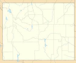
Sherman is a ghost town in Albany County, Wyoming. It's a place where people used to live, but now it's mostly empty. It's about 19 miles (30 km) southeast of Laramie, high up in the Laramie Mountains. The town was named after a famous general from the American Civil War, William Tecumseh Sherman.
From the 1860s until 1918, Sherman was a busy stop on the very first transcontinental railroad line, built by the Union Pacific Railroad. It was located at a very high point, about 8,247 feet (2,514 meters) above sea level.
Before it was called Sherman, Union Pacific workers named the area Lone Tree Pass or Evans Pass. The name Evans Pass honored James A. Evans. He was a surveyor who found a shorter path for the railroad through Wyoming. This new path was much shorter than the older trails that crossed at South Pass.
The town of Sherman was eventually abandoned. This happened after the Union Pacific Railroad moved its tracks to a different, lower route. Even though the town is gone, the original spot is still home to the Ames Monument. The railroad built this monument to mark its first highest point. Today, the highest points on the Overland Route (a modern railroad line), Interstate 80, and U.S. Route 30 are called Sherman Summit or Sherman Hill Summit. These spots are about 7.5 miles (12 km) north-northwest of where the old town used to be.
Contents
Sherman: A Ghost Town Story
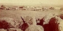
The small town of Sherman grew up right next to the railroad tracks. Trains would stop there to change engines during their long journey across the country. This stop was important! It had a roundhouse with five stalls, which is like a garage for train engines. It also had a turntable to turn the engines around. There were two section houses (buildings for railroad workers) and a windmill with a water tank.
Trains were carefully checked at Sherman. After the check, they would begin a long trip downhill. They could go east towards Cheyenne or west across the 130-foot (40-meter) high Dale Creek Bridge to the Laramie Valley. The parts for the original wooden bridge west of Sherman were made in Chicago. Then, they were shipped to the site and put together. When it was finished in 1868, this bridge was the highest railroad bridge in the world!
A few hundred people lived in Sherman. It was a tough place, rocky and barren. But it had a general store, a post office, a schoolhouse, two hotels (the Sherman House and Summit House), and two saloons.
In 1885, a man named William Murphy bought the land where the Ames Monument stood. He wanted to cover the monument with advertisements! But the Union Pacific Railroad Company had other plans. They got a special deed for the property in 1889.
The railroad company moved its tracks two times. They wanted to find flatter routes over the Laramie Mountains. Each time, this made Sherman's future less certain. The town's end came in 1918. That's when the railroad closed its station and moved the tracks about three miles (5 km) south. Soon, everyone left Sherman. All that remains today is a small cemetery.
High Points Nearby
Interstate 80 Summit
Sherman Summit, also known as Sherman Hill Summit, is a mountain pass about 7.5 miles (12 km) north-northwest of the old ghost town. It sits at an elevation of 8,640 feet (2,633 meters). While it's not a super rugged mountain crossing, it is the highest point on the transcontinental Interstate 80. The Abraham Lincoln Memorial Monument is located there today.
Lincoln Highway's Highest Point
Just southwest of the current Sherman Summit, at about 8,820 feet (2,688 meters) high, is the highest point on the original Lincoln Highway. This was America's first transcontinental highway. Today, this spot is part of U.S. 30. This location, where the old road is still visible, is simply called The Summit. A very large bronze statue of Abraham Lincoln used to stand here. It has since been moved to the Sherman Summit.
Overland Route's New High Point
Because the railroad tracks were moved, the highest point on the modern Overland Route is now different. It's about 3.4 miles (5.5 km) southeast of the Ames Monument. This new high point is at an elevation of 8,014 feet (2,443 meters). There isn't a town there, but the railroad officially calls this spot Sherman. However, this point isn't actually on the very top of the Laramie Mountains. The trains now go through the nearby Hermosa Tunnel, which is a bit lower at 7,960 feet (2,426 meters).
 | Dorothy Vaughan |
 | Charles Henry Turner |
 | Hildrus Poindexter |
 | Henry Cecil McBay |


