
Laramie Mountains facts for kids
Quick facts for kids Laramie Mountains |
|
|---|---|

Southern face of Laramie Peak
|
|
| Highest point | |
| Peak | South Bald Mountain |
| Elevation | 11,007 ft (3,355 m) |
| Geography | |

The Laramie Mountains are shown highlighted in pink on a map of the western U.S.
|
|
| Country | United States |
| Parent range | Rocky Mountains |
The Laramie Mountains are a chain of mountains on the eastern side of the Rocky Mountains. You can find them in the U.S. states of Wyoming and Colorado. They are the northernmost part of the mountain ranges that run along the eastern side of the Rockies, especially connected to the taller Front Range mountains just south of them. North of these mountains, there's a gap between the Laramie range and the Bighorn Mountains. This gap was an important path for famous historical routes like the Oregon Trail, the Mormon Trail, and the Pony Express.
The Laramie Mountains start in northern Colorado. They stretch into southeastern Wyoming, between the cities of Cheyenne and Laramie, and then continue north towards Casper. Some people even say the Laramies are only in Wyoming. The mountains get their name from the Laramie River. This river cuts through the range from southwest to northeast and joins the North Platte River east of the mountains. The mountains also gave their name to the Laramide orogeny. This was a huge uplift of the North American Plate that happened about 70 million years ago, creating the Rocky Mountains we see today.
Most of the highest parts of the Laramie Mountains are public land. They are part of the Medicine Bow-Routt and Roosevelt national forests.
Mountain Features

The Laramie Mountains are made up of many granite peaks that rise from a wide, flat area. This flat area is mostly open grassland, about 7,000 feet (2,134 meters) above sea level. The tall peaks of the range rise suddenly from this flat land. They are usually between 8,000 and 9,500 feet (2,438 and 2,896 meters) high.
There are two special exceptions. Laramie Peak in Wyoming reaches 10,274 feet (3,132 meters). South Bald Mountain in Colorado is even taller, at 11,007 feet (3,355 meters). The soil in these mountains is mostly granite, which means it's not very deep.

The Laramie Mountains have different types of natural areas, called "life zones." These include the Upper Sonoran, Transition, and Canadian zones. On the eastern and northeastern sides of the range, the land gently changes from flat prairie to mountains near Cheyenne and Laramie. Farther north, this change is much steeper. The lowest point is about 4,500 feet (1,370 meters) along the North Platte River.
On the western side, the land doesn't change as much in height. The flat areas between the mountains, called basins, are usually above 7,000 feet (2,134 meters). A large, high plain and semi-desert stretch from the Laramie Mountains southwest towards the Shirley Mountains. The Laramie Basin separates the Laramie Mountains from the Medicine Bow Mountains to the south and west. This basin's floor is mostly above 7,000 feet (2,134 meters).
The Laramie River cuts right through the Laramie Mountains. It forms a canyon west of Wheatland. Then, it continues east to join the North Platte River near Fort Laramie. This river divides the mountains into two parts. The southern part is generally drier and more open, with fewer forests. However, the southern end, around Pole Mountain, has interesting granite rock formations called Vedauwoo. These are popular for rock climbing and picnics.
You can easily see the Laramie Mountains from Interstate 25 when driving between Casper and Cheyenne. Interstate 80 and the Union Pacific Railroad also cross a part of the range between Cheyenne and Laramie. This area is known as the "Gangplank."
Images for kids
-
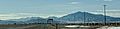
Laramie Mountains viewed from 40 miles West on U.S. Route 26. From right to left: Laramie peak, South Mountain, and Bearhead Mountain.
