Wheatland, Wyoming facts for kids
Quick facts for kids
Wheatland, Wyoming
|
|
|---|---|

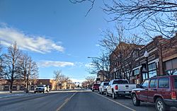
Downtown Wheatland
|
|

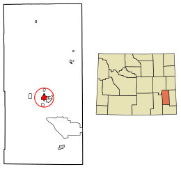
Location of Wheatland in Platte County, Wyoming.
|
|
| Country | |
| State | |
| County | |
| Area | |
| • Total | 4.10 sq mi (10.61 km2) |
| • Land | 4.10 sq mi (10.61 km2) |
| • Water | 0.00 sq mi (0.00 km2) |
| Elevation | 4,751 ft (1,448 m) |
| Population
(2020)
|
|
| • Total | 3,588 |
| • Density | 875.5/sq mi (338.1/km2) |
| Time zone | UTC-7 (Mountain (MST)) |
| • Summer (DST) | UTC-6 (MDT) |
| ZIP code |
82201
|
| Area code(s) | 307 |
| FIPS code | 56-83040 |
| GNIS feature ID | 1609173 |
Wheatland is a town in southeastern Wyoming, United States. It is also the county seat of Platte County. In 2020, the town had a population of 3,588 people.
Contents
History of Wheatland
Before the late 1800s, the area where Wheatland now stands was a flat, dry land. It had plants that grow in desert-like conditions.
Building an Irrigation System
In 1883, a group of people, including local rancher Joseph M. Carey, started the Wyoming Development Company. They wanted to bring water to the "Wheatland Flats" to help farms grow. They hoped this would lead to new towns and businesses.
By the end of 1883, they built an irrigation system. This system included a long tunnel to move water into Bluegrass Creek. It also had the first two canals for watering the land.
Railroad and Town Growth
The Cheyenne and Northern Railway line reached the Wheatland Flats in July 1887. This helped connect the area to other places. The railway line was later sold to the Colorado and Southern Railway.
In 1894, land lots in the new town of Wheatland were sold. By 1915, many farms were set up in the area that used the irrigation system. The population of the Wheatland Flats grew to 5,277 people.
Becoming a County Seat
In 1911, Platte County was created from part of Albany County. Wheatland was chosen as the main town, or county seat. The Platte County Courthouse was built in Wheatland in 1917.
Today, the Wheatland Irrigation District is still the largest privately owned irrigation system in the United States.
Geography of Wheatland
Wheatland is located at 42°3′14″N 104°57′34″W / 42.05389°N 104.95944°W. The town covers a total area of about 4.10 square miles (10.61 square kilometers). All of this area is land.
Population and People
| Historical population | |||
|---|---|---|---|
| Census | Pop. | %± | |
| 1910 | 796 | — | |
| 1920 | 1,336 | 67.8% | |
| 1930 | 1,997 | 49.5% | |
| 1940 | 2,110 | 5.7% | |
| 1950 | 2,286 | 8.3% | |
| 1960 | 2,350 | 2.8% | |
| 1970 | 2,498 | 6.3% | |
| 1980 | 5,816 | 132.8% | |
| 1990 | 3,271 | −43.8% | |
| 2000 | 3,548 | 8.5% | |
| 2010 | 3,627 | 2.2% | |
| 2020 | 3,588 | −1.1% | |
| 2023 (est.) | 3,509 | −3.3% | |
| U.S. Decennial Census | |||
2010 Population Details
In 2010, there were 3,627 people living in Wheatland. There were 1,657 households and 974 families. The town had about 884.6 people per square mile (341.5 people per square kilometer).
Most of the people in Wheatland were White (95.1%). About 7.4% of the population was Hispanic or Latino.
About 25% of households had children under 18 living with them. The average age of people in Wheatland was 45.4 years old.
Climate in Wheatland
Wheatland has a semi-arid climate. This means it has cold, dry winters and hot summers with more rain.
| Climate data for Wheatland 4N, Wyoming (1991–2020 normals, extremes 1893–present) | |||||||||||||
|---|---|---|---|---|---|---|---|---|---|---|---|---|---|
| Month | Jan | Feb | Mar | Apr | May | Jun | Jul | Aug | Sep | Oct | Nov | Dec | Year |
| Record high °F (°C) | 70 (21) |
74 (23) |
86 (30) |
91 (33) |
98 (37) |
108 (42) |
107 (42) |
112 (44) |
101 (38) |
92 (33) |
86 (30) |
76 (24) |
112 (44) |
| Mean maximum °F (°C) | 60.2 (15.7) |
63.2 (17.3) |
74.2 (23.4) |
80.9 (27.2) |
88.9 (31.6) |
95.7 (35.4) |
99.9 (37.7) |
98.0 (36.7) |
94.2 (34.6) |
84.2 (29.0) |
70.7 (21.5) |
61.7 (16.5) |
100.6 (38.1) |
| Mean daily maximum °F (°C) | 43.3 (6.3) |
45.1 (7.3) |
55.4 (13.0) |
62.1 (16.7) |
71.1 (21.7) |
82.7 (28.2) |
90.3 (32.4) |
89.0 (31.7) |
80.2 (26.8) |
65.6 (18.7) |
52.4 (11.3) |
42.8 (6.0) |
65.0 (18.3) |
| Daily mean °F (°C) | 30.0 (−1.1) |
30.8 (−0.7) |
39.8 (4.3) |
46.1 (7.8) |
55.1 (12.8) |
65.4 (18.6) |
72.2 (22.3) |
70.5 (21.4) |
61.6 (16.4) |
48.8 (9.3) |
38.0 (3.3) |
29.5 (−1.4) |
49.0 (9.4) |
| Mean daily minimum °F (°C) | 16.6 (−8.6) |
16.5 (−8.6) |
24.1 (−4.4) |
30.0 (−1.1) |
39.2 (4.0) |
48.0 (8.9) |
54.1 (12.3) |
52.0 (11.1) |
43.1 (6.2) |
32.0 (0.0) |
23.7 (−4.6) |
16.2 (−8.8) |
33.0 (0.6) |
| Mean minimum °F (°C) | −12.2 (−24.6) |
−6.1 (−21.2) |
5.7 (−14.6) |
15.8 (−9.0) |
26.8 (−2.9) |
39.2 (4.0) |
45.6 (7.6) |
42.9 (6.1) |
31.0 (−0.6) |
15.1 (−9.4) |
−0.4 (−18.0) |
−10.0 (−23.3) |
−19.5 (−28.6) |
| Record low °F (°C) | −36 (−38) |
−36 (−38) |
−25 (−32) |
−22 (−30) |
13 (−11) |
28 (−2) |
29 (−2) |
25 (−4) |
12 (−11) |
−9 (−23) |
−19 (−28) |
−39 (−39) |
−39 (−39) |
| Average precipitation inches (mm) | 0.28 (7.1) |
0.42 (11) |
0.74 (19) |
1.70 (43) |
2.70 (69) |
2.12 (54) |
1.73 (44) |
1.17 (30) |
1.29 (33) |
1.14 (29) |
0.45 (11) |
0.39 (9.9) |
14.13 (359) |
| Average snowfall inches (cm) | 4.6 (12) |
7.8 (20) |
7.4 (19) |
5.4 (14) |
1.4 (3.6) |
0.0 (0.0) |
0.0 (0.0) |
0.0 (0.0) |
0.1 (0.25) |
3.2 (8.1) |
4.3 (11) |
5.7 (14) |
39.9 (101) |
| Average precipitation days (≥ 0.01 in) | 2.7 | 3.4 | 3.6 | 5.7 | 7.8 | 7.5 | 6.3 | 5.8 | 5.4 | 4.3 | 3.0 | 2.8 | 58.3 |
| Average snowy days (≥ 0.1 in) | 2.7 | 3.2 | 2.8 | 2.0 | 0.6 | 0.0 | 0.0 | 0.0 | 0.2 | 1.1 | 2.4 | 3.1 | 18.1 |
| Source: NOAA | |||||||||||||
Education in Wheatland
Kids in Wheatland go to public schools run by Platte County School District #1. The schools serving the town are:
- Libbey Elementary School (for grades K–2)
- West Elementary School (for grades 3–5)
- Wheatland Middle School (for grades 6–8)
- Wheatland High School (for grades 9–12)
Wheatland also has a public library. It is part of the Platte County Public Library System.
Getting Around Wheatland
Roads and Highways
Several important roads pass through or near Wheatland:
 I-25 - This major highway goes around the west side of town.
 US 87 - This road runs north and south through Wheatland.
- Other state routes include WY 310 (Hightower Rd.), WY 312 (Ferguson Rd.), WY 316 (Antelope Gap Rd.), and WY 320 (No. Wheatland Hwy.).
Bus Service
You can find intercity bus service in Wheatland provided by Express Arrow.
Air Travel
Wheatland has a small airport called Phifer Airfield. It is just east of town. However, this airport does not have regular commercial flights. People who want to fly usually go to larger airports nearby. These include Western Nebraska Regional Airport, Casper–Natrona County International Airport, and Cheyenne Regional Airport.
Railroads
Wheatland was once home to the historic Wheatland station. This station was operated by the Union Pacific, Denver and Gulf Railway. Today, the station is not open for passengers. However, the train tracks through Wheatland are still used by Berkshire Hathaway's BNSF Railway. BNSF Railway has small offices in Wheatland.
Arts and Culture in Wheatland
Wheatland hosts the yearly Platte County Fair & Rodeo. This event usually takes place in the second full week of August. It is held at the fairgrounds on the east side of town.
The famous horse named Steamboat was kept near Wheatland. Steamboat was the model for the bucking horse and rider symbol. This symbol is seen on Wyoming's license plates. It is also the logo for the University of Wyoming.
Notable People from Wheatland
Many interesting people have connections to Wheatland:
- Benjamin N. Bellis (1924–2019), a United States Air Force Lieutenant General.
- Freckles Brown (1921–1987), a world champion bull rider.
- Edward Bryant (1945–2017), a science fiction and fantasy writer.
- Jim Geringer (born 1944), a former governor of Wyoming.
- Robert Mills Grant (1926–2012), a rancher and politician who served in the Wyoming House of Representatives.
- Jeremy Haroldson, a pastor and member of the Wyoming House of Representatives.
- Charles Hoskinson (born 1987), who founded Cardano (blockchain platform) and co-founded Ethereum.
- Floyd Shaman (1935–2005), a sculptor.
- Dennis Utter (1939–2011), a state legislator from Nebraska.
See also
 In Spanish: Wheatland (Wyoming) para niños
 | Laphonza Butler |
 | Daisy Bates |
 | Elizabeth Piper Ensley |


