Medicine Bow Mountains facts for kids
Quick facts for kids Medicine Bow Mountains |
|
|---|---|

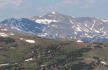
Clark Peak viewed from Rocky Mountain National Park
|
|
| Highest point | |
| Peak | Clark Peak |
| Elevation | 12,951 ft (3,947 m) |
| Dimensions | |
| Length | 100 mi (160 km) |
| Geography | |
| Country | United States |
| Range coordinates | 40°49.7′N 106°4.7′W / 40.8283°N 106.0783°W |
| Parent range | Rocky Mountains |
The Medicine Bow Mountains are a long mountain range. They are part of the Rocky Mountains. These mountains stretch about 100 miles (160 km). They go from northern Colorado into southern Wyoming. The northern part of this range is called the Snowy Range.
The mountains start near Cameron Pass in Colorado. They follow the border between Larimer and Jackson counties. Then they go north into south-central Wyoming. In Wyoming, they are west of Laramie. They are found in Albany and Carbon counties. The mountains are a well-known symbol for the city of Laramie. The Snowy Range Ski Area is also located here.
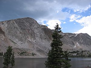
The highest point in the range is Clark Peak. It stands at 12,960 feet (3,950 meters) tall. Clark Peak is in the Rawah Wilderness. It is located at the southern end of the range in Northern Colorado. Much of the range is within the Medicine Bow National Forest in Wyoming. The highest peak on the Wyoming side is Medicine Bow Peak. It is 12,013 feet (3,662 meters) high.
Rivers drain the mountains on both sides. The Michigan and Canadian rivers flow from the western side. They are branches of the North Platte River. On the eastern side, the Laramie River drains the mountains. It is also a branch of the North Platte River.
How the Mountains Formed
The Medicine Bow Mountains were formed by a process called the Laramide Orogeny. This happened about 70 million years ago. During this time, the Earth's crust pushed together. This caused large blocks of rock to break and lift up. These blocks were made of very old rock called Precambrian granite.
By 50 million years ago, most of Wyoming's main mountain ranges were formed. The areas between them, called basins, also took shape. The rocks you see in the Medicine Bow Mountains today are from different time periods. The highest peaks are made of a rock called Medicine Peak Quartzite. This rock is 2.4 to 2.0 billion years old. It was once sand at the bottom of a shallow sea. Over time, it was buried, squeezed, and heated. This turned it into a hard metamorphic rock called quartzite. Scientists have even found possible traces of ancient animals in this rock. This makes it very interesting for paleontologists, who study old life forms.
The Cheyenne belt is also found in these mountains. This is a very old boundary where two large pieces of North America joined together. This happened about 1.78 to 1.74 billion years ago.
Animals of the Mountains
These mountains are full of different kinds of wildlife. You can find mule deer, elk, and moose here. There are also black bears and mountain lions. Smaller animals include coyotes, marmots, pikas, and Richardson's ground squirrels. You might also spot bobcats and lynx.
Many different types of birds live in the area too. The streams are home to various fish. These include brook trout, rainbow trout, grayling, and golden trout. In some lakes in the northern part of the range, a special type of arctic fairy shrimp has been found.
Mountain Research
Since 1987, a special research site has been active in the Snowy Range. It's called the Glacier Lakes Ecosystem Experiments Site (GLEES). This site is run by the United States Forest Service. Scientists here study many things. They look at how air pollution settles on the land. They also study how forests take in and release carbon and water vapor. Researchers also investigate the effects of insect outbreaks on the trees. They study the water in alpine lakes and streams too.
The site covers about 642 hectares (1,586 acres). It has equipment for important programs. These include the National Atmospheric Deposition Program (NADP) and the National Dry Deposition Network (NDDN). It also hosts AmeriFlux, which measures how gases move between ecosystems and the atmosphere.
 | Percy Lavon Julian |
 | Katherine Johnson |
 | George Washington Carver |
 | Annie Easley |


