Canadian River (North Platte River tributary) facts for kids
Quick facts for kids Canadian River |
|
|---|---|
 |
|
| Physical characteristics | |
| Main source | Confluence of North Fork and South Fork 40°36′56″N 106°01′14″W / 40.61556°N 106.02056°W |
| River mouth | Confluence with North Platte 7,851 ft (2,393 m) 40°53′28″N 106°19′39″W / 40.89111°N 106.32750°W |
| Basin features | |
| Progression | North Platte—Platte— Missouri—Mississippi |
The Canadian River is a cool river in north central Colorado, in the United States. It's about 55 miles (89 km) long. This river is a branch, or tributary, of the North Platte River.
It flows through Jackson County. The Canadian River helps drain the eastern part of a large valley called North Park. This valley is located along the western side of the Medicine Bow Mountains.
Where the River Starts
The Canadian River begins high up in the mountains. It starts from several smaller streams. These streams flow down from the southwest side of the Medicine Bow Mountains. You can find its beginnings near a peak called Clark Peak. This area is in southeastern Jackson County. It's also north of a small place called Gould.
Its Journey Through Colorado
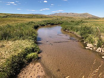
As the Canadian River flows, it heads northwest. It passes through the beautiful Colorado State Forest. When it reaches the valley floor, the river spreads out. It becomes a "braided stream," which means it splits into many smaller channels that weave together.
The river then flows through ranch lands. It generally stays along the eastern edge of the valley. It flows roughly parallel to another river, the Michigan River, which is to its west.
Where It Ends
Finally, the Canadian River meets the North Platte River. This happens in north central Jackson County. The meeting point is about 7 miles (12 km) north of Walden. It's also about 2 miles (3 km) downstream from where the Michigan River joins the North Platte.
 | William L. Dawson |
 | W. E. B. Du Bois |
 | Harry Belafonte |

