North Park (Colorado basin) facts for kids
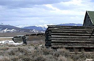
North Park is a large, high valley located in the Rocky Mountains of north-central Colorado, United States. It sits about 8,800 feet (2,680 meters) above sea level. This wide valley is found in Jackson County. It is surrounded by tall mountain ranges. Many rivers start here, including the North Platte River, Michigan River, Illinois River, and Canadian River.
The valley is called "North Park" because it's the northernmost of three big mountain valleys in Colorado. These valleys are on the western side of the Front Range mountains. The other two are Middle Park and South Park.
North Park opens up towards Wyoming in the north. The North Platte River flows in this direction. To the east, you'll find the Medicine Bow Mountains. The Never Summer Mountains and Rabbit Ears Range are to the south. The Park Range is to the west. The continental divide runs along the south and west edges of the Park.
The main jobs in North Park are cattle ranching and cutting down trees for wood, which is called timber harvesting. However, timber harvesting has become much less common recently. The biggest town in the valley is Walden. It is the main town of Jackson County. Walden is located near the middle of the valley where the Michigan and Illinois rivers meet. Smaller communities like Gould and Rand are also in the valley.
Important roads cross North Park. State Highway 14 goes from east to west. It comes from the east over Cameron Pass. This road connects North Park to the Poudre Canyon and Fort Collins. Highway 14 also enters from the west over Muddy Pass. This gives access to Steamboat Springs and Middle Park.
State Highway 125 goes from north to south. It enters from the north (from Wyoming) along the North Platte River. From the south, it crosses Willow Creek Pass. This road leads to the upper part of Middle Park near Granby. The valley along the Illinois River is home to the Arapaho National Wildlife Refuge. This refuge is a special protected area for animals and plants.
Exploring North Park's Geology
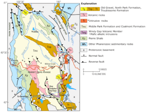
The ground beneath North Park is made of Mesozoic sedimentary rocks. These rocks form a bowl-shaped area called a structural basin. The layers of rock here are similar to those found in nearby areas. These include the Green River Basin to the west and the Denver Basin to the east.
Signs from the Fish and Wildlife Service near Walden explain the area's past. Long ago, North Park was a shallow sea. You can even find fossilized shark teeth in the area! This shows how much the land has changed over millions of years.
Oil and Gas Resources
For a long time, oil has been found in North Park. It comes from underground rock formations called the Muddy Sandstone. These oil fields are known as North McCallum and South McCallum. In 2007, North Park produced about 96,000 barrels of oil. It also produced 1.3 billion cubic feet of natural gas from 153 wells.
In 2008, a company called EOG Resources had great success. They drilled new types of wells in the Niobrara Formation. This rock layer is from the Cretaceous period. These new wells helped to find even more oil.
 | Percy Lavon Julian |
 | Katherine Johnson |
 | George Washington Carver |
 | Annie Easley |


