Park Range (Colorado) facts for kids
Quick facts for kids Park Range |
|
|---|---|

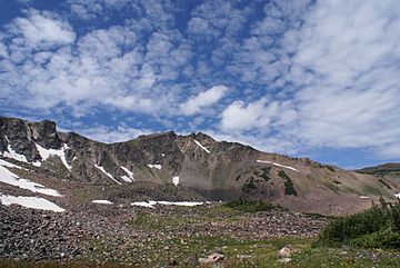
West face of Mount Zirkel
|
|
| Highest point | |
| Peak | Mount Zirkel |
| Elevation | 12,182 ft (3,713 m) |
| Dimensions | |
| Length | 40 mi (64 km) N-S |
| Geography | |
| Country | United States |
| Parent range | Rocky Mountains |
The Park Range is a group of mountains in the Rocky Mountains of northwestern Colorado, United States. These mountains are about 12,000 feet (3,700 m) high. They form a special part of the Continental Divide. This is a line that separates rivers flowing to the Pacific Ocean from those flowing to the Atlantic Ocean.
The Park Range stretches for about 40 miles (64 km) from north to south. It sits along the border between Jackson County on the east and Routt County on the west. The range separates two important river areas. To the east is North Park, where the North Platte River begins. To the west is the Elk River basin, which is part of the Yampa River system. The mountains rise steeply from the Yampa River basin. This creates a natural barrier that gets a lot of snow in winter. The northern part of the Park Range extends into Wyoming and is called the Sierra Madre Range.
Contents
Exploring the Park Range
The Park Range is a beautiful and important part of Colorado. It offers many outdoor activities and is home to special natural areas.
Popular Places to Visit
Many people enjoy visiting the Park Range. One popular spot is Steamboat Springs. This town is a famous ski resort. It is located on the southwestern side of the range, at the base of Mount Werner.
Much of the Park Range is part of the Routt National Forest. A national forest is a large area of land protected by the government. It is managed for many uses, including recreation and wildlife.
Mount Zirkel Wilderness
High up in the Park Range is the Mount Zirkel Wilderness. A wilderness area is a very special place where nature is protected. It is kept as wild as possible, with very few human changes. This wilderness area is named after Mount Zirkel. Mount Zirkel is the highest peak in the range, reaching 12,182 ft (3,713 m).
The Park Range can be seen clearly from both sides. It creates a beautiful view from many parts of North Park.
Mountain Passes and Roads
Two main roads cross the Park Range. At its southern end, Rabbit Ears Pass carries US 40. This is a major highway that connects different towns.
Another pass is Buffalo Pass. This pass has a gravel road that connects Steamboat Springs and Walden. During the summer, when the weather is good, most vehicles can use this road.
 | Claudette Colvin |
 | Myrlie Evers-Williams |
 | Alberta Odell Jones |


