
Yampa River facts for kids
Quick facts for kids Yampa River |
|
|---|---|

The Yampa River, c. 1871–1878
|
|

Map of the Yampa River watershed
|
|
| Country | United States |
| State | Colorado |
| Cities | Steamboat Springs, Craig, Hayden |
| Physical characteristics | |
| Main source | Rocky Mountains 7,833 ft (2,387 m) 40°9′30″N 106°53′59″W / 40.15833°N 106.89972°W |
| River mouth | Green River Dinosaur National Monument 5,080 ft (1,550 m) 40°31′44″N 108°59′3″W / 40.52889°N 108.98417°W |
| Length | 250 mi (400 km) |
| Basin features | |
| Basin size | 7,660 sq mi (19,800 km2) |
| Tributaries |
|
The Yampa River is a special river that flows for about 250 miles (400 km) through northwestern Colorado in the United States. It starts high up in the Rocky Mountains and eventually joins the Green River, which is a big part of the larger Colorado River system. What makes the Yampa River unique is that it's one of the few major rivers in the western U.S. that still flows freely, without many big dams or diversions changing its path.
The name "Yampa" comes from the Snake Indians. It refers to a plant called Perideridia, which has an edible root. An explorer named John C. Frémont wrote about the name "Yampah" in his journal back in 1843. He noticed that this plant was very common along the river.
Contents
Where Does the Yampa River Flow?
The Yampa River begins in the Park Range in Routt County, Colorado. It forms where two smaller streams, the Bear River and Phillips Creek, meet near the town of Yampa. The Bear River, which is the larger of the two, starts even higher up, at about 11,600 feet (3,500 meters) on Derby Peak.
Journey Through Valleys and Canyons
The Yampa River first flows north through a high mountain valley. It passes through Stagecoach Reservoir and Lake Catamount. Then, it reaches Steamboat Springs, where it makes a sharp turn to the west. After Steamboat Springs, the river moves through a wider valley at the base of the Rocky Mountains. It is joined by the Elk River from the north and then flows past the towns of Milner and Hayden.
As the Yampa enters Moffat County, it goes past Craig and meets the Williams Fork. West of Craig, the river flows through dry, open land covered in sagebrush for about 50 miles (80 km). It then reaches Cross Mountain Canyon, where the river has carved a deep, 1,000-foot (300-meter) gap through the mountain.
Below Cross Mountain, the Yampa enters a wide valley called Lily Park. Here, its biggest tributary, the Little Snake River, joins it. Further west, the Yampa River enters Dinosaur National Monument. Inside the monument, it travels through more than 40 miles (64 km) of rough canyons and exciting rapids. Finally, the Yampa River joins the Green River in Echo Park at Steamboat Rock, deep within the national monument, close to the Colorado–Utah border.
The Yampa River's Home: Its Watershed
The Yampa River's watershed is the area of land that drains water into the river. This watershed covers about 7,660 square miles (19,800 square kilometers). Most of this area is a dry, flat plateau in northwestern Colorado, with a small part in southern Wyoming.
The watershed is surrounded by mountains: the Park Range to the east, the Flat Tops to the south, and the Uinta Mountains to the west. To the north, the Yampa River basin is next to the Great Divide Basin, which is a unique area where water doesn't flow out to the ocean. The Continental Divide, which separates rivers flowing to the Atlantic from those flowing to the Pacific, runs along the north and east sides of the Yampa basin. This separates it from the rivers that feed into the North Platte River and eventually the Mississippi River. To the south, the Yampa River basin borders the White River basin, which also flows west to join the Green River.
How Much Water Does the Yampa River Carry?
.jpg)
The Yampa River is like many rivers in the Western U.S. because its water levels depend on melting snow. But unlike most, its flow patterns aren't changed much by big dams or water projects. The river often forms a wide, shallow, braided stream, meaning it splits into many smaller channels that weave together.
The lower three-quarters of the Yampa, from the Elk River downstream, are usually good for small boats. However, because the river is shallow and winding, it can be hard to navigate in late summer, especially in years with low water.
The river's average flow where it meets the Green River is about 2,154 cubic feet per second (61 cubic meters per second). During the spring when snow melts (April to July), the flow averages around 5,400 cubic feet per second (153 cubic meters per second). In late summer and autumn, it drops below 500 cubic feet per second (14 cubic meters per second). The upper part of the river freezes over between December and March.
A U.S. Geological Survey station at Deerlodge Park, about 50 miles (80 km) from the river's mouth, measured the average flow between 1983 and 2013 as 2,082 cubic feet per second (59 cubic meters per second). The highest average flow for a year was in 2011, at 4,431 cubic feet per second (125 cubic meters per second), and the lowest was in 2002, at 678 cubic feet per second (19 cubic meters per second). The highest monthly average flows were in May, at 8,200 cubic feet per second (232 cubic meters per second), and the lowest were in September, at 342 cubic feet per second (10 cubic meters per second). The biggest rush of water ever recorded was 33,200 cubic feet per second (940 cubic meters per second) on May 18, 1984, during a huge snowmelt.
What Lives Along the Yampa River?
Because the Yampa River flows mostly naturally, it creates a healthy environment along its banks called a riparian zone. This area is full of life! Also, much of the river isn't held back by levees, so its natural floodplain (the flat land next to the river that floods) can stay healthy. The same is true for its main tributary, the Little Snake River.
The Yampa River Preserve, located about 17 miles (27 km) west of Steamboat Springs, protects a special type of forest. This forest has trees like narrowleaf cottonwood, box elder, and red-osier dogwood. These trees used to be more common in the Upper Colorado River Basin. The Yampa's warm, silty (muddy) waters are also perfect for native fish to lay their eggs, such as the Colorado pikeminnow and humpback chub. These fish have mostly disappeared from other parts of the Colorado River system where dams have changed the water.
A Look at the Yampa River's Past

Ancient Peoples and the Yampa River
Studies in the Dinosaur National Monument show that people lived in the Yampa River area as far back as 7000 BC! Later, around 800 AD, a group called the Fremont culture (or Desert Archaic people) lived in the Yampa River basin. They disappeared around the 1400s, and we're not sure why. The Fremont people left behind amazing petroglyphs (rock carvings) along the Yampa River Canyon, and more than 300 of them can still be seen today.
After the Fremont culture faded, a group of Utes moved into the Yampa River basin. The White River Utes lived in the valleys of the Yampa and White Rivers and the Rocky Mountains of northwestern Colorado. The Ute group living in the Yampa River valley was known as the Yamparika or Yapudttka Utes. Sometimes, the river also acted as a border between the Utes and the Comanche people to the north. There was even a Comanche group called the Yamparika.
The name Yamparika comes from the Snake Indians and means "yampa eaters." "Yampa" itself likely meant "water-plant" or "common plant." In 1843, explorer John C. Frémont was one of the first to write down the name "Yampah" because he found so many of these plants in the area. Some fur traders in the 1800s thought Yampa was the Ute word for "bear," so the Yampa was often called the Bear River on early maps.
Plans for Dams and Water Diversions
In the 1960s, there were plans to flood the Yampa and Green River canyons to create a huge reservoir behind the Echo Park Dam. This was a water project by the U.S. Bureau of Reclamation. However, environmental groups strongly opposed this dam, and it was never built. This is why the Yampa River is still free-flowing today! As a compromise to save Echo Park, two other controversial dam projects, Glen Canyon and Flaming Gorge, were allowed to go forward, damming the Colorado and Green Rivers. Today, the Yampa is still the only major river in the Colorado River system that doesn't have a single large dam along its main course. (There are a few smaller dams like the moderately sized Stagecoach Dam, built in 1989, and others on its headwaters, but they don't have a huge impact on its overall flow.)
In December 2006, a report suggested a new plan: to pump water from the Yampa River 200 miles (320 km) east, under the Continental Divide, to the big cities along Colorado's Front Range. This diversion was planned to start near Maybell, about 20 miles (32 km) downstream from Craig, Colorado. This idea faced a lot of opposition because it could significantly lower the river's flow in late summer.
Images for kids
-
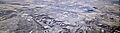
The Yampa River, aerial view from the south, with the Craig Station coal-fired power plant and the municipality of Craig, Colorado, at the far right, and the town of Maybell, Colorado, at the far left; November 2017
