White River (Green River tributary) facts for kids
Quick facts for kids White River |
|
|---|---|

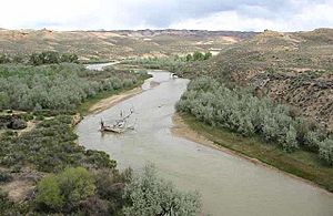
The White River in Uintah County, Utah
|
|

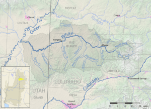
Map of the White River watershed
|
|
| Other name(s) | Rio Blanco |
| Country | United States |
| State | Colorado, Utah |
| Cities | Meeker, Colorado, Rangely, Colorado, Bonanza, Utah, Ouray, Utah |
| Physical characteristics | |
| Main source | Confluence of North Fork and South Fork Rio Blanco County, Colorado 6,932 ft (2,113 m) 39°58′22″N 107°38′18″W / 39.97278°N 107.63833°W |
| River mouth | Green River Uintah County, Utah 4,646 ft (1,416 m) 40°03′44″N 109°40′45″W / 40.06222°N 109.67917°W |
| Length | 195 mi (314 km) |
| Basin features | |
| River system | Colorado River |
| Basin size | 5,120 sq mi (13,300 km2) |
| Tributaries |
|
The White River is a river in the western United States. It flows for about 195 miles (314 km). This river runs through the states of Colorado and Utah.
The White River is a tributary of the Green River. A tributary is a smaller river or stream that flows into a larger river. The Green River then flows into the mighty Colorado River.
Contents
Where the White River Flows

The White River starts in northwestern Colorado. It has two main parts, called forks. These forks are in the Flat Tops Wilderness Area. This area is part of the White River National Forest.
North and South Forks
The North Fork begins at Wall Lake. It flows first northwest, then southwest. The South Fork starts about ten miles south of the North Fork. It flows southwest, then northwest, past Spring Cave.
These two forks meet near Buford. This is in eastern Rio Blanco County. When they join, they form the main White River.
Journey Through Colorado and Utah
From Buford, the White River flows west, then northwest. It passes by the town of Meeker. You can find the White River Museum in Meeker. The river then crosses a wide valley. This valley is between the Danforth Hills to the north and the Roan Plateau to the south.
After Meeker, other streams join the White River. These include Piceance Creek and Yellow Creek. In western Rio Blanco County, the river turns southwest. It flows past Rangely. Here, Douglas Creek adds its waters to the White River.
The river then crosses into Uintah County, Utah. Finally, it joins the Green River. This meeting point is about 2 miles (3 km) south of Ouray.
Small boats can travel on most parts of the White River. However, during dry years, the water level can get very low. This means boats might not be able to pass for several months.
The amount of water flowing in the river changes a lot. In late summer of dry years, it might be around 400 cubic feet per second. But in spring, when snow melts, it can be over 3,000 cubic feet per second!
Climate Around the River
The area around the White River has a semi-arid climate. This means it's quite dry, but not a full desert. It gets some rain, but not a lot. On climate maps, this type of weather is often shown as "BSk."
 | John T. Biggers |
 | Thomas Blackshear |
 | Mark Bradford |
 | Beverly Buchanan |


