Rio Blanco County, Colorado facts for kids
Quick facts for kids
Rio Blanco County
|
|
|---|---|

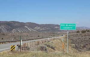
Entering the county from the south on State Highway 13.
|
|

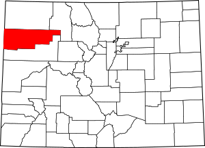
Location within the U.S. state of Colorado
|
|
 Colorado's location within the U.S. |
|
| Country | |
| State | |
| Founded | March 25, 1889 |
| Named for | White River |
| Seat | Meeker |
| Largest town | Meeker |
| Area | |
| • Total | 3,223 sq mi (8,350 km2) |
| • Land | 3,221 sq mi (8,340 km2) |
| • Water | 1.9 sq mi (5 km2) 0.06% |
| Population
(2020)
|
|
| • Total | 6,529 |
| • Estimate
(2023)
|
6,569 |
| • Density | 2.0/sq mi (0.8/km2) |
| Time zone | UTC−7 (Mountain) |
| • Summer (DST) | UTC−6 (MDT) |
| Congressional district | 3rd |
Rio Blanco County is a county in the state of Colorado, USA. Its name means "White River" in Spanish, named after the White River that flows through it. In 2020, about 6,529 people lived here. The main town and county seat is Meeker.
Contents
History of Rio Blanco County
Rio Blanco County was officially created on March 25, 1889. It was formed by splitting off from Garfield County. The town of Meeker was chosen as the county seat right away.
In 1973, something unique happened here. Scientists conducted an experiment called Project Rio Blanco. They used peaceful underground explosions to try and release natural gas from deep within the earth. This was part of a bigger project called Operation Plowshare.
Geography and Nature
Rio Blanco County covers a large area of about 3,223 square miles. Most of this area, about 3,221 square miles, is land. A small part, about 1.9 square miles, is water.
Neighboring Counties
Rio Blanco County shares borders with several other counties:
- To the north: Moffat County
- To the northeast: Routt County
- To the south: Garfield County
- To the west: Uintah County in Utah
Main Roads
Important roads that help people travel through the county include:
Protected Natural Areas
The county is home to beautiful natural spaces, including parts of:
- Routt National Forest
- White River National Forest
- Flat Tops Wilderness
Scenic Drives
You can enjoy beautiful views on these special roads:
- Dinosaur Diamond Prehistoric Highway National Scenic Byway
- Flat Tops Trail Scenic Byway
State Parks and Wildlife
- Colorow Mountain State Wildlife Area is a place where wildlife is protected.
Population and People
| Historical population | |||
|---|---|---|---|
| Census | Pop. | %± | |
| 1890 | 1,200 | — | |
| 1900 | 1,690 | 40.8% | |
| 1910 | 2,332 | 38.0% | |
| 1920 | 3,135 | 34.4% | |
| 1930 | 2,980 | −4.9% | |
| 1940 | 2,943 | −1.2% | |
| 1950 | 4,719 | 60.3% | |
| 1960 | 5,150 | 9.1% | |
| 1970 | 4,842 | −6.0% | |
| 1980 | 6,255 | 29.2% | |
| 1990 | 5,972 | −4.5% | |
| 2000 | 5,986 | 0.2% | |
| 2010 | 6,666 | 11.4% | |
| 2020 | 6,529 | −2.1% | |
| 2023 (est.) | 6,569 | −1.5% | |
| U.S. Decennial Census 1790-1960 1900-1990 1990-2000 2010-2020 |
|||
In 2020, the county's population was 6,529 people. Over the years, the number of people living in Rio Blanco County has changed, as you can see in the chart above.
Education in Rio Blanco County
Students in Rio Blanco County attend schools in two main districts: Meeker School District RE-1 and Rangely School District RE-4. There is also a private school called Rangely Christian Academy for younger students.
For higher education, the county has Colorado Northwestern Community College in Rangely. There is also an extension of Colorado State University located in Meeker.
Towns and Communities
The county has two main towns:
Towns
Smaller Communities
There are also smaller, unincorporated communities:
- Buford
- White River City
See also
 In Spanish: Condado de Río Blanco para niños
 | Misty Copeland |
 | Raven Wilkinson |
 | Debra Austin |
 | Aesha Ash |

