Routt County, Colorado facts for kids
Quick facts for kids
Routt County
|
|
|---|---|

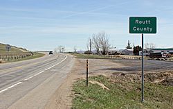
Entering Routt County from the west on U.S. Route 40
|
|

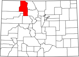
Location within the U.S. state of Colorado
|
|
 Colorado's location within the U.S. |
|
| Country | |
| State | |
| Founded | January 29, 1877 |
| Named for | John Long Routt |
| Seat | Steamboat Springs |
| Largest city | Steamboat Springs |
| Area | |
| • Total | 2,368 sq mi (6,130 km2) |
| • Land | 2,362 sq mi (6,120 km2) |
| • Water | 6.1 sq mi (16 km2) 0.3%% |
| Population
(2020)
|
|
| • Total | 24,829 |
| • Density | 11/sq mi (4/km2) |
| Time zone | UTC−7 (Mountain) |
| • Summer (DST) | UTC−6 (MDT) |
| Congressional district | 2nd |
Routt County is a county in the state of Colorado, USA. In 2020, about 24,829 people lived here. The main town and county seat is Steamboat Springs. Routt County is also part of the Steamboat Springs Micropolitan Statistical Area, which means it's a smaller city area with close ties to nearby communities.
Contents
History of Routt County
People first found gold near Hahns Peak in 1864. This was during the time of the Colorado Gold Rush, when many people came to Colorado looking for gold.
Routt County was officially created on January 29, 1877. It was formed from the western part of Grand County. The county was named after John Long Routt. He was an important person in Colorado's history, serving as the last governor when Colorado was a territory and then the first governor after it became a state. Later, on February 27, 1911, the western part of Routt County became its own county, called Moffat County.
Geography and Nature
Routt County covers a total area of about 2,368 square miles. Most of this area, about 2,362 square miles, is land. A small part, about 6.1 square miles, is water.
Neighboring Counties
Routt County shares its borders with several other counties and even a state:
- Carbon County, Wyoming - to the north
- Jackson County - to the east
- Grand County - to the southeast
- Eagle County - to the south
- Garfield County - to the south-southwest
- Rio Blanco County - to the southwest
- Moffat County - to the west
Main Roads
These are the most important highways that go through Routt County:
Protected Natural Areas
Routt County is home to several beautiful natural areas that are protected:
- Mount Zirkel Wilderness
- Routt National Forest
- Sarvis Creek Wilderness
- White River National Forest
State Parks
You can also find these state parks in Routt County, great for outdoor activities:
Trails and Scenic Routes
If you love hiking, biking, or scenic drives, Routt County has these famous trails and byways:
- Continental Divide National Scenic Trail
- Fish Creek Falls National Recreation Trail
- Flat Tops Trail Scenic Byway
- Great Parks Bicycle Route
- Swamp Park National Recreation Trail
People of Routt County
| Historical population | |||
|---|---|---|---|
| Census | Pop. | %± | |
| 1880 | 140 | — | |
| 1890 | 2,369 | 1,592.1% | |
| 1900 | 3,661 | 54.5% | |
| 1910 | 7,561 | 106.5% | |
| 1920 | 8,948 | 18.3% | |
| 1930 | 9,352 | 4.5% | |
| 1940 | 10,525 | 12.5% | |
| 1950 | 8,940 | −15.1% | |
| 1960 | 5,900 | −34.0% | |
| 1970 | 6,592 | 11.7% | |
| 1980 | 13,404 | 103.3% | |
| 1990 | 14,088 | 5.1% | |
| 2000 | 19,690 | 39.8% | |
| 2010 | 23,509 | 19.4% | |
| 2020 | 24,829 | 5.6% | |
| 2023 (est.) | 25,064 | 6.6% | |
| U.S. Decennial Census 1790-1960 1900-1990 1990-2000 2010-2020 |
|||
In 2000, there were 19,690 people living in Routt County. There were 7,953 households and 4,779 families. The county had about 8 people per square mile.
Most people in Routt County were White (96.90%). A smaller number were Native American (0.49%), Asian (0.39%), or Black (0.13%). About 3.22% of the population were Hispanic or Latino.
About 31.10% of households had children under 18 living with them. The average household had 2.44 people, and the average family had 2.92 people.
The median age in Routt County was 35 years old. This means half the people were younger than 35 and half were older. About 22.60% of the population was under 18.
The median income for a household was $53,612 per year. For families, it was $61,927. The average income per person was $28,792. About 6.10% of the population lived below the poverty line.
Education in Routt County
Routt County has several public school districts for students:
- Hayden School District RE-1, which serves the town of Hayden.
- Steamboat Springs School District RE-2, which serves Steamboat Springs.
- South Routt School District RE-3, which serves Oak Creek and Yampa.
There are also other schools like Steamboat Mountain School in Steamboat Springs and North Routt Community Charter School in Clark.
For college students, Routt County is home to the Steamboat Springs campus of Colorado Mountain College. This college is special because it's the only one in the United States that offers a degree in Ski & Snowboard Business. This program teaches students about the business side of snow sports, like how to sell, make, and market ski and snowboard gear.
Towns and Communities
Routt County has one city, several towns, and other smaller communities:
City
Towns
Census-designated place
Other places
See also
 In Spanish: Condado de Routt para niños
 | John T. Biggers |
 | Thomas Blackshear |
 | Mark Bradford |
 | Beverly Buchanan |

