Toponas, Colorado facts for kids
Quick facts for kids
Toponas, Colorado
|
|
|---|---|

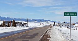
Entering Toponas on State Highway 131.
|
|
| Country | |
| State | |
| County | Routt County |
| Elevation | 8,284 ft (2,525 m) |
| Time zone | UTC-7 (MST) |
| • Summer (DST) | UTC-6 (MDT) |
| ZIP code |
80479
|
| GNIS feature ID | 0173099 |
Toponas is a small, unincorporated community located in Routt County, Colorado, United States. An unincorporated community means it's a group of homes and businesses that isn't officially a town or city with its own local government.
Contents
What is Toponas Like?
Toponas got its name from a nearby rock formation called Toponas Rock. In 2010, about 48 people lived here. By 2017, the number was estimated to be around 26.
What You Can Find in Toponas
As of 2015, Toponas has a large general store. This store also has gas pumps for cars. You can also see a few ranch houses and other small buildings. A post office is located just west of the main village. It has been open since 1888 and serves the area's ZIP Code, which is 80479.
Where is Toponas Located?
Toponas is found at these coordinates: 40.057841 degrees North and -106.801357 degrees West. It sits in a wide mountain pass. This pass is important because it's on the dividing line between two major rivers. To the north is the Yampa River, and to the south is the Colorado River.
Important Travel Routes
Because of its location, Toponas is a key spot for travel. State Highway 131 goes right through the community. Also, an old railroad line, once part of the Denver and Rio Grande Western Railroad, passes through Toponas. This line used to connect to Craig.
Toponas is also at the western end of State Highway 134. This highway leads up to Gore Pass. It's one of two main roads connecting the Yampa Valley and Middle Park.
 | Shirley Ann Jackson |
 | Garett Morgan |
 | J. Ernest Wilkins Jr. |
 | Elijah McCoy |


