
Eagle County, Colorado facts for kids
Quick facts for kids
Eagle County
|
|||
|---|---|---|---|

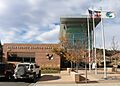
The Eagle County Justice Center (county courthouse) in Eagle
|
|||
|
|||

Location within the U.S. state of Colorado
|
|||
 Colorado's location within the U.S. |
|||
| Country | |||
| State | |||
| Founded | February 11, 1883 | ||
| Named for | Eagle River | ||
| Seat | Eagle | ||
| Largest community | Edwards | ||
| Area | |||
| • Total | 1,692 sq mi (4,380 km2) | ||
| • Land | 1,685 sq mi (4,360 km2) | ||
| • Water | 7.3 sq mi (19 km2) 0.4%% | ||
| Population
(2020)
|
|||
| • Total | 55,731 | ||
| • Density | 33/sq mi (13/km2) | ||
| Time zone | UTC−7 (Mountain) | ||
| • Summer (DST) | UTC−6 (MDT) | ||
| Congressional districts | 2nd, 3rd | ||

Eagle County is a county in the state of Colorado, United States. In 2020, about 55,731 people lived there. The main town, or county seat, is Eagle. The biggest community is Edwards. The county gets its name from the Eagle River.
Eagle County is also part of the Edwards, Colorado, Micropolitan Statistical Area. This means it's a smaller area with a city and nearby communities that are closely connected.
Contents
History of Eagle County
Eagle County was created by the Colorado government on February 11, 1883. It was formed from parts of Summit County. The county was named after the Eagle River, which flows through it. The first county seat was Red Cliff. In 1921, the county seat was moved to the town of Eagle.
A mine called the Ground Hog Mine, near Red Cliff, found gold and silver in 1887. One part of the mine had gold that looked like crystals. Another part had gold that looked like thin wires, shaped like "ram's horns." One of these unique gold pieces is now in the Harvard Mineralogical Museum.
Geography and Nature
Eagle County has amazing mountains and rivers. The highest point in the county is the Mount of the Holy Cross. It stands at 14,011 feet (4,270 meters) above sea level. The lowest point is along the Colorado River, at 6,128 feet (1,868 meters).
The county covers about 1,692 square miles (4,382 square kilometers). Most of this area, about 1,685 square miles (4,364 square kilometers), is land. Only a small part, about 7.3 square miles (19 square kilometers), is water.
A large part of Eagle County is covered by the White River National Forest. This is a protected area of trees and wildlife. Other parts of the county are managed by the Bureau of Land Management. This agency takes care of public lands. Interstate 70 is a major highway that crosses the county from east to west.
The Eagle River starts in the southeastern part of the county. It joins with Gore Creek and then flows into the Colorado River in the west. The Fryingpan River and the Roaring Fork River also touch the southwest corner of the county.
Neighboring Counties
Eagle County shares borders with these other counties:
- Grand County – to the northeast
- Summit County – to the east
- Lake County – to the south
- Pitkin County – to the southwest
- Garfield County – to the west
- Routt County – to the northwest
Main Roads and Highways
These are the major roads that go through Eagle County:
 Interstate 70
 I-70 Bus.
- I-70 Bus.
- I-70 Bus.
 U.S. Highway 6
 U.S. Highway 24
 State Highway 82
 State Highway 131
Protected Natural Areas
Eagle County is home to several important natural areas:
- White River National Forest
- Eagles Nest Wilderness
- Flat Tops Wilderness
- Holy Cross Wilderness
State Parks
Hiking and Recreation Trails
You can find these trails in Eagle County:
- Colorado Trail
- Continental Divide National Scenic Trail
- Two Elk National Recreation Trail
- Vail Pass National Recreation Trail
Scenic Drives
These roads offer beautiful views:
- Colorado River Headwaters National Scenic Byway
- Top of the Rockies National Scenic Byway
Population and People
| Historical population | |||
|---|---|---|---|
| Census | Pop. | %± | |
| 1890 | 3,725 | — | |
| 1900 | 3,008 | −19.2% | |
| 1910 | 2,985 | −0.8% | |
| 1920 | 3,385 | 13.4% | |
| 1930 | 3,924 | 15.9% | |
| 1940 | 5,361 | 36.6% | |
| 1950 | 4,488 | −16.3% | |
| 1960 | 4,677 | 4.2% | |
| 1970 | 7,498 | 60.3% | |
| 1980 | 13,320 | 77.6% | |
| 1990 | 21,928 | 64.6% | |
| 2000 | 41,659 | 90.0% | |
| 2010 | 52,197 | 25.3% | |
| 2020 | 55,731 | 6.8% | |
| 2023 (est.) | 54,381 | 4.2% | |
| U.S. Decennial Census 1790–1960 1900–1990 1990–2000 2010–2020 |
|||
In 2000, there were 41,659 people living in Eagle County. The population density was about 25 people per square mile. Most people in the county were White. About 23% of the population was Hispanic or Latino.
The average age of people in the county was 31 years old. About 23.5% of the population was under 18. Many people, about 42%, were between 25 and 44 years old.
Education in Eagle County
Public Schools
Eagle County School District RE-50J manages the public schools. The district has eight elementary schools, three middle schools, and three high schools. These schools are located across Eagle County.
Private and Other Schools
- Vail Christian High School (in Edwards)
- Vail Mountain School (in Vail)
- Vail Ski & Snowboard Academy (in Minturn)
Colleges and Universities
Colorado Mountain College has a campus in Edwards. This college serves many communities in western Colorado.
Life Expectancy
People in Eagle County tend to live a long time. In 2014, the average life expectancy was about 85.94 years. This was one of the longest life expectancies in the entire United States. Men lived about 84.4 years on average, and women lived about 87.6 years. Two nearby counties, Summit and Pitkin counties, also have very high life expectancies.
Experts say that several things help people live longer in these Colorado counties. These include good education, higher incomes, easy access to doctors, and people being very active. Also, fewer people in these areas are overweight compared to other places.
Communities in Eagle County
Towns
Census-Designated Places (CDPs)
These are areas that are like towns but are not officially incorporated:
Other Unincorporated Places
These are smaller communities that are not officially towns or CDPs:
- Beaver Creek
- Bond
- Burns
- Eagle-Vail
- Sheephorn
- Sweetwater
Ghost Towns
These are towns that used to exist but are now abandoned:
- Gilman
- Holy Cross City
Images for kids
-
The Eagle County Justice Center in Eagle
See also
 In Spanish: Condado de Eagle para niños
