Roaring Fork River facts for kids
Quick facts for kids Roaring Fork River |
|
|---|---|

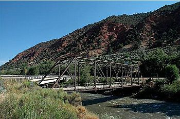
Hardwick Bridge crossing the Roaring Fork River, between Carbondale and Glenwood Springs
|
|

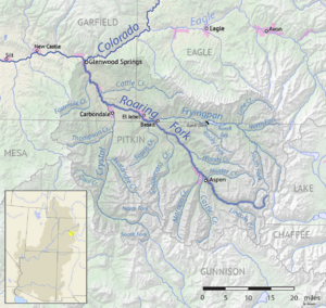
Map of the Roaring Fork River
|
|
| Country | United States |
| State | Colorado |
| Physical characteristics | |
| Main source | Independence Lake White River National Forest, Pitkin County 12,490 ft (3,810 m) 39°08′38″N 106°34′04″W / 39.14389°N 106.56778°W |
| River mouth | Colorado River Glenwood Springs, Garfield County 5,718 ft (1,743 m) 39°32′57″N 107°19′47″W / 39.54917°N 107.32972°W |
| Length | 70 mi (110 km) |
| Basin features | |
| Basin size | 1,453 sq mi (3,760 km2) |
| Tributaries |
|
The Roaring Fork River is a cool river in Colorado, United States. It's about 70 miles (113 km) long. This river is a "tributary," which means it flows into a bigger river. The Roaring Fork River flows into the Colorado River.
The river helps drain a busy and important area in western Colorado. This area is called the Roaring Fork Valley. It includes popular places like the resort city of Aspen.
Contents
About the Roaring Fork River
The Roaring Fork River is known for its clear water. It flows quickly and is quite deep and powerful. You can travel on the river in small boats for most of its length. On average, a lot of water flows through it every second.
Where Does It Start and Go?
The Roaring Fork River begins high up in the Sawatch Range mountains. This is in eastern Pitkin County. It starts near Independence Pass, which is on the continental divide. A continental divide is like a high ridge where water flows to different oceans.

From its start, the river flows northwest. It passes through towns like Aspen, Woody Creek, and Snowmass. Along its journey, other rivers join it. The Fryingpan River flows into it near Basalt. A bit further down, the Crystal River joins it from the south. Finally, the Roaring Fork River meets the Colorado River in Glenwood Springs.
The Roaring Fork Watershed
The entire area that drains water into the Roaring Fork River is called the Roaring Fork Watershed. A watershed is like a giant bowl where all the rain and snowmelt eventually flow into one main river. This watershed is quite large, covering about 1,451 square miles (3,758 square kilometers). That's about the same size as the state of Rhode Island!
Fun on the River
The Roaring Fork River flows through many canyons. This makes it a very popular spot for outdoor activities. Many people enjoy whitewater rafting on the river. It's a thrilling way to experience the beautiful Colorado landscape.
The river also helps supply water to other areas. Some of its water is sent through the Sawatch Range to the Twin Lakes Reservoir using the Twin Lakes Tunnel.
The Roaring Fork Conservancy is an organization that works to protect this important river and all the smaller streams that flow into it. They help keep the water clean and healthy for everyone.
See also
 In Spanish: Río Roaring Fork para niños
 | Lonnie Johnson |
 | Granville Woods |
 | Lewis Howard Latimer |
 | James West |

