
Aspen, Colorado facts for kids
Quick facts for kids
Aspen, Colorado
|
|||
|---|---|---|---|

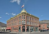
Downtown Aspen (2005)
|
|||
|
|||

Location within Pitkin County and Colorado
|
|||

Aspen, Colorado
Location in the United States

Aspen, Colorado
Location in Colorado
|
|||
| Country | |||
| State | |||
| County | Pitkin County seat | ||
| Settled | 1879 | ||
| Incorporation | 1881 | ||
| Named for | Aspen trees around the city | ||
| Government | |||
| • Type | Council–manager | ||
| Area | |||
| • Home Rule City | 3.858 sq mi (9.992 km2) | ||
| • Land | 3.858 sq mi (9.992 km2) | ||
| • Water | 0 sq mi (0.000 km2) | ||
| Elevation | 7,891 ft (2,405 m) | ||
| Highest elevation
(At SW corner of city boundary)
|
8,460 ft (2,580 m) | ||
| Lowest elevation
(Roaring Fork at N corner of city)
|
7,660 ft (2,330 m) | ||
| Population
(2020)
|
|||
| • Home Rule City | 7,004 | ||
| • Density | 1,815/sq mi (701/km2) | ||
| • Metro | 79,043 | ||
| • CSA | 134,774 | ||
| Time zone | UTC−07:00 (MST) | ||
| • Summer (DST) | UTC−06:00 (MDT) | ||
| ZIP Code |
81611, 81612 (PO Boxes)
|
||
| Area code(s) | 970 | ||
| FIPS code | 08-03620 | ||
| GNIS ID | 204686 | ||
| INCITS place code | 0803620 | ||

Aspen is a special city in Colorado, United States. It is the main city of Pitkin County, Colorado. In 2020, about 7,004 people lived there. Aspen is located high up in the Rocky Mountains, near the Roaring Fork River. It sits at an elevation of almost 8,000 feet (2,400 meters).
Aspen started as a mining town during the Colorado Silver Boom in the 1880s. It was named Aspen because of the many aspen trees in the area. The town grew very quickly at first. But when the silver market crashed in 1893, many people left. For the next 50 years, the population became very small.
In the mid-1900s, Aspen became popular again. This happened when Aspen Mountain was turned into a ski resort. A businessman named Walter Paepcke helped rebuild the city. Today, Aspen is home to important places like the Aspen Music Festival and School, the Aspen Institute, and the Aspen Center for Physics.
Later in the 1900s, Aspen became a favorite spot for famous people. Singer John Denver even wrote songs about Aspen. The city is now a popular place to visit all year round. People enjoy outdoor activities like skiing and hiking. Aspen is known for having some of the most expensive homes in the world.
Contents
History of Aspen


Aspen's story began in the winter of 1879. A group of miners arrived, even though the Governor of Colorado asked them to stay away. This was because the Ute people were trying to protect their lands. The community was first called Ute City.
In 1880, it was renamed Aspen. By 1891 and 1892, Aspen was the most successful silver-mining area in the United States. This was helped by a law called the Sherman Silver Purchase Act of 1890. This law made the government buy more silver. By 1893, Aspen had many modern services. It had banks, a hospital, a police department, and even electric lights.
However, the good times ended in 1893 with the Panic of 1893. The President stopped the silver purchase law. Many mines in Aspen closed, and thousands of miners lost their jobs. The town's population dropped a lot. By 1930, only 705 people lived there.
Aspen started to recover in the 1930s. People began to see its potential as a ski resort. But this plan was put on hold because of World War II. After the war, a skier named Friedl Pfeifer teamed up with businessman Walter Paepcke. They started the Aspen Skiing Company in 1946.
Aspen quickly became a famous ski resort. It even hosted the FIS World Championships in 1950. Walter Paepcke also helped bring a big cultural event to Aspen in 1949. This event helped Aspen become known as an international cultural center. More ski areas were built, including Buttermilk (1958), Aspen Highlands (1958), and Snowmass (1967).
In the 1970s, Aspen became a popular place for rich and famous people. John Denver was one of the well-known residents. In 1978, Aspen was fully photographed for the Aspen Movie Map project. This was one of the first examples of virtual reality software.
Aspen is also known for its local media. It has a public radio station, KJAX, and a public TV station, Grassroots TV. There are also three commercial radio stations and two daily newspapers. These include The Aspen Times and The Aspen Daily News.
Aspen's Image Today

Aspen has changed a lot in recent years. The cost of homes has gone up very high. Many people buy second homes there. This makes it hard for people who work in Aspen to afford to live there. Many workers now live in nearby towns.
The downtown area of Aspen has become a luxury shopping district. You can find high-end restaurants, salons, and fancy stores. Shops like Gucci, Prada, and Fendi are common. This makes Aspen a very glamorous place.
Geography of Aspen
Aspen is located in the southeastern part of the Roaring Fork Valley. It sits along the Roaring Fork River. This river flows into the Colorado River. Aspen is surrounded by mountains and wilderness areas. To the north is Red Mountain, to the east is Smuggler Mountain, and to the south is Aspen Mountain.
The city is connected by State Highway 82. This is the main road into Aspen. Other mountain roads exist, but they need special vehicles. These roads are usually closed in winter due to snow. Highway 82 east of Aspen is also closed in winter. This means the only way to drive to Aspen in winter is from the west.
In 2020, the city covered an area of about 3.86 square miles (9.992 square kilometers). All of this area is land.
Climate in Aspen
Aspen has a humid continental climate. This is because it is very high up in the mountains. The temperature changes a lot between day and night. Summer days are warm, but winter nights can be very cold. However, summer nights are not usually freezing. Winter days often stay above freezing.
| Climate data for Aspen, Colorado, 1991–2020 normals, extremes 1980–present | |||||||||||||
|---|---|---|---|---|---|---|---|---|---|---|---|---|---|
| Month | Jan | Feb | Mar | Apr | May | Jun | Jul | Aug | Sep | Oct | Nov | Dec | Year |
| Record high °F (°C) | 58 (14) |
60 (16) |
68 (20) |
74 (23) |
86 (30) |
88 (31) |
91 (33) |
88 (31) |
86 (30) |
78 (26) |
70 (21) |
62 (17) |
91 (33) |
| Mean maximum °F (°C) | 48.6 (9.2) |
51.7 (10.9) |
59.4 (15.2) |
67.3 (19.6) |
76.1 (24.5) |
82.8 (28.2) |
85.4 (29.7) |
83.4 (28.6) |
79.5 (26.4) |
72.9 (22.7) |
60.6 (15.9) |
50.2 (10.1) |
85.8 (29.9) |
| Mean daily maximum °F (°C) | 32.0 (0.0) |
35.3 (1.8) |
42.7 (5.9) |
49.7 (9.8) |
60.0 (15.6) |
70.6 (21.4) |
75.5 (24.2) |
73.1 (22.8) |
66.9 (19.4) |
55.2 (12.9) |
41.6 (5.3) |
31.9 (−0.1) |
52.9 (11.6) |
| Daily mean °F (°C) | 20.9 (−6.2) |
23.9 (−4.5) |
31.2 (−0.4) |
38.1 (3.4) |
47.5 (8.6) |
56.4 (13.6) |
61.8 (16.6) |
60.1 (15.6) |
53.4 (11.9) |
42.5 (5.8) |
30.5 (−0.8) |
21.1 (−6.1) |
40.6 (4.8) |
| Mean daily minimum °F (°C) | 9.9 (−12.3) |
12.5 (−10.8) |
19.8 (−6.8) |
26.6 (−3.0) |
35.0 (1.7) |
42.2 (5.7) |
48.1 (8.9) |
47.1 (8.4) |
40.0 (4.4) |
29.8 (−1.2) |
19.4 (−7.0) |
10.3 (−12.1) |
28.4 (−2.0) |
| Mean minimum °F (°C) | −6.4 (−21.3) |
−4.5 (−20.3) |
2.7 (−16.3) |
12.3 (−10.9) |
22.6 (−5.2) |
31.2 (−0.4) |
40.2 (4.6) |
39.5 (4.2) |
28.1 (−2.2) |
13.1 (−10.5) |
1.3 (−17.1) |
−7.7 (−22.1) |
−10.9 (−23.8) |
| Record low °F (°C) | −20 (−29) |
−25 (−32) |
−14 (−26) |
0 (−18) |
15 (−9) |
20 (−7) |
29 (−2) |
29 (−2) |
18 (−8) |
−5 (−21) |
−13 (−25) |
−23 (−31) |
−25 (−32) |
| Average precipitation inches (mm) | 1.93 (49) |
2.23 (57) |
2.59 (66) |
2.68 (68) |
2.17 (55) |
1.06 (27) |
1.97 (50) |
1.75 (44) |
1.89 (48) |
2.09 (53) |
2.09 (53) |
2.00 (51) |
24.45 (621) |
| Average snowfall inches (cm) | 28.1 (71) |
28.3 (72) |
26.9 (68) |
20.9 (53) |
7.0 (18) |
0.4 (1.0) |
0.0 (0.0) |
0.0 (0.0) |
1.0 (2.5) |
10.2 (26) |
20.5 (52) |
27.5 (70) |
170.8 (433.5) |
| Average extreme snow depth inches (cm) | 29.1 (74) |
36.5 (93) |
35.3 (90) |
21.2 (54) |
4.2 (11) |
0.2 (0.51) |
0.0 (0.0) |
0.0 (0.0) |
0.5 (1.3) |
5.0 (13) |
11.3 (29) |
19.2 (49) |
39.0 (99) |
| Average precipitation days (≥ 0.01 in) | 12.7 | 12.7 | 11.3 | 13.0 | 11.0 | 6.9 | 11.3 | 12.5 | 10.0 | 9.4 | 9.9 | 12.2 | 132.9 |
| Average snowy days (≥ 0.1 in) | 12.0 | 11.6 | 9.5 | 8.4 | 2.5 | 0.2 | 0.0 | 0.0 | 0.7 | 4.0 | 8.3 | 11.3 | 68.5 |
| Average relative humidity (%) | 62.9 | 60.0 | 54.1 | 50.1 | 46.9 | 42.8 | 47.4 | 52.3 | 50.6 | 52.3 | 59.7 | 64.5 | 53.6 |
| Mean daily sunshine hours | 7 | 8 | 8 | 9 | 10 | 11 | 10 | 9 | 9 | 8 | 6 | 6 | 8 |
| Average ultraviolet index | 2 | 4 | 6 | 8 | 10 | 11 | 11 | 10 | 8 | 5 | 3 | 2 | 7 |
| Source: NOAA Weatherbase (humidity) Weather Atlas (daily sunshine hours and UV index) | |||||||||||||
People and Homes in Aspen


| Historical population | |||
|---|---|---|---|
| Census | Pop. | %± | |
| 1890 | 5,108 | — | |
| 1900 | 3,303 | −35.3% | |
| 1910 | 1,834 | −44.5% | |
| 1920 | 1,265 | −31.0% | |
| 1930 | 705 | −44.3% | |
| 1940 | 777 | 10.2% | |
| 1950 | 916 | 17.9% | |
| 1960 | 1,101 | 20.2% | |
| 1970 | 2,437 | 121.3% | |
| 1980 | 3,678 | 50.9% | |
| 1990 | 5,049 | 37.3% | |
| 2000 | 5,914 | 17.1% | |
| 2010 | 6,658 | 12.6% | |
| 2020 | 7,004 | 5.2% | |
| U.S. Decennial Census | |||
In 2003, there were 5,914 people living in Aspen. Most people in Aspen are White (94.94%). About 6.14% of the population is Hispanic or Latino.
The average age in Aspen was 37 years old. Many people are between 25 and 44 years old. There were more males than females in the city. The average income for a family was $70,300. A small number of people (8.2%) lived below the poverty line.
Housing in Aspen
Homes in Aspen are very expensive. They are among the most costly in the entire country. In 2021, the average price for a single family home was $9.5 million. A study in 2023 said that Aspen has the most expensive ski resort homes in the world.
It is hard for workers to find affordable places to live in Aspen. The Aspen Pitkin County Housing Authority helps with this. They have programs for people who work in the area. These homes have rules to keep them affordable for local residents. But even these homes can cost close to $1 million.
Sports in Aspen

Aspen is a big place for sports. The Winter X Games have been held at Buttermilk (ski area) since 2002. This event features extreme winter sports. Two famous freestyle skiers from Aspen are Torin Yater-Wallace and Alex Ferreira. They both compete in the Winter X Games and have been in the Olympic Games.
Aspen also has a local rugby team called the Gentlemen of Aspen. They have won the Rugby Super League several times.
Education in Aspen
Aspen High School is the only high school in the Aspen School District. In 2012, it was ranked as the top high school in Colorado. It was also ranked 59th in the United States. The high school has grades 9 to 12. It has about 540 students and 41 teachers. Olympic cross-country skier Noah Hoffman went to this school.
About 13% of the students are minorities, mostly Hispanic. The school has a high number of students in the International Baccalaureate program.
Transportation in Aspen
- Buses: The Roaring Fork Transportation Authority (RFTA) offers free bus service within Aspen and Snowmass Village. They also have paid service to nearby towns. You can take Amtrak to Glenwood Springs and then use RFTA to get to Aspen.
- Airport: Aspen has its own airport, Aspen-Pitkin County Airport. It is also called Sardy Field. Major airlines like American, Delta, and United fly there.
- Roads: State Highway 82 is the main road to Aspen. Other mountain roads are usually closed in winter. This means Highway 82 west of Aspen is the only way to drive there in winter.
- Bike Sharing: WE-CYCLE is a bike-sharing system in Aspen and Basalt. It has 16 stations and 200 bikes.
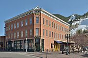
Historic Buildings in Aspen
-
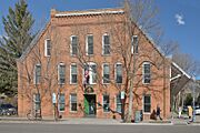
Armory Hall or Fraternal Hall (Aspen City Hall)
-
Elks building
-
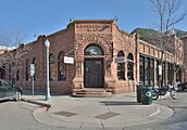
Cowenhoven Ute City Banque building
-
Independence building


Sister Cities of Aspen
Aspen has several sister cities around the world:
 Abetone Cutigliano, Italy
 Bariloche, Argentina
 Chamonix-Mont-Blanc, France
 Davos, Switzerland
 Garmisch-Partenkirchen, Germany
 Queenstown, New Zealand
 Shimukappu, Japan
Notable People from Aspen
See Also
 In Spanish: Aspen para niños
