Independence Pass (Colorado) facts for kids
Quick facts for kids Independence Pass |
|
|---|---|
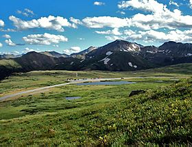
View across pass from slopes of unnamed peak to the north
|
|
| Elevation | 12,095 feet (3,687 m)NAVD 88 |
| Traversed by | |
| Location | Lake / Pitkin counties, Colorado, U.S. |
| Range | Sawatch |
| Coordinates | 39°06′29″N 106°33′52″W / 39.10806°N 106.56444°W |
| Topo map | USGS Independence Pass |
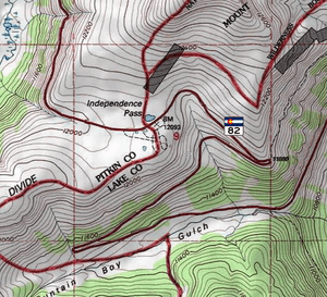
Independence Pass, once called Hunter Pass, is a very high mountain pass in central Colorado, United States. It sits at an elevation of 12,095 ft (3,687 m). This pass is located on the Continental Divide, which is like a natural line where water on one side flows to the Atlantic Ocean and water on the other side flows to the Pacific. It's part of the Sawatch Range in the Rocky Mountains.
The pass is found right in the middle of Aspen and Twin Lakes. It also marks the border between Pitkin and Lake counties. State Highway 82 crosses over it. This makes Independence Pass the second-highest paved state highway in Colorado that goes all the way through.
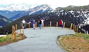
Because of how high it is, the pass gets a lot of snow. It closes every winter, which means Aspen is cut off from direct travel from the east during ski season. When the weather is warmer and the pass is open, it's a popular spot for visitors. There's a scenic overlook where you can see the alpine tundra (a treeless, cold environment) and amazing views of Mount Elbert. Mount Elbert is Colorado's tallest mountain.
People who love rock climbing come here for bouldering (climbing on large rocks). There are also paths to nearby mountain tops. Backcountry skiers enjoy the slopes in late spring and early summer. Since 2011, the pass has been part of the USA Pro Cycling Challenge bike race route.
The pass was shaped by glaciers and erosion over many years. Zebulon Pike first saw it in 1806. Later, Ferdinand Vandeveer Hayden surveyed it in 1873. At that time, the land west of the pass was for the Ute people. But on July 4, 1879, gold seekers crossed the pass, ignoring the governor's orders. They named it Independence Pass after the holiday. They also started a village called Independence (now a ghost town).
A toll road was built across the pass, but it was later left unused when a railroad reached Aspen. A new road, which became Highway 82, was built in the 1920s. You can still see parts of the old road today. The Independence Pass Foundation, a group based in Aspen, has been working since 1984 to fix environmental damage caused by the roads.
Contents
Exploring Independence Pass
The main ridge of the Sawatch Range and the Continental Divide turn southwest at Independence Pass. North of the pass, the land rises to a tall, unnamed peak. To the south, the ridge goes up more gently towards Grizzly Peak.
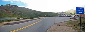
The pass has a large parking lot along Highway 82. It's split between Pitkin and Lake counties. It's also part of the White River and San Isabel national forests. Nearby are the Collegiate Peaks Wilderness and Mount Massive Wilderness areas.
Near the parking area, you'll find a small building and restrooms. These are looked after by the U.S. Forest Service. A paved path leads to two overlooks. From here, you can see Mount Elbert, the highest peak in Colorado, and La Plata Peak, another very tall mountain. A dirt path continues south along the ridge. Across the road, another path leads to other peaks. The overlook has a marker for the Continental Divide, but geologists say the true Divide is actually a bit west, near the Linkins Lake trail.
The pass is about halfway along a 32-mile (51 km) stretch of Highway 82. This part of the road is sometimes called Independence Pass itself. Aspen is 19 miles (31 km) to the west, and Twin Lakes is 18 miles (29 km) to the east.
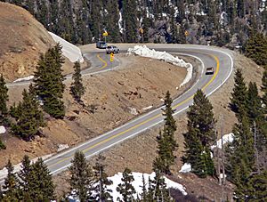
The road leading to the pass is very steep, with a 6 percent grade and sharp turns called switchbacks. The western side follows the narrow valley of the Roaring Fork River, which starts from Independence Lake. The eastern side follows the North Fork of Lake Creek, which flows into Twin Lakes Reservoir and the Arkansas River.
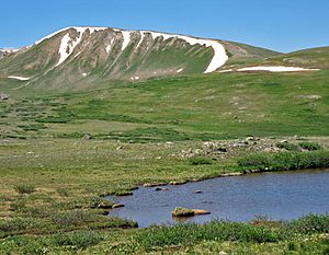
Since the pass is above the tree line, the area around it is alpine tundra. This means there are open grassy areas, low shrubs, and bare rocks. Snow can stay in some spots all year. Next to the road, there are small pools of water that appear and disappear, and a larger, permanent one north of the road.
Weather at the Pass
Independence Pass has a subarctic climate (Köppen Dfc). This means it has cold, snowy winters and cool summers. The pass gets a lot of snow, averaging about 335 inches (852.7 cm) each year.
| Climate data for Independence Pass, Colorado, 1991–2020 normals, 1985-2020 extremes: 10600ft (3231m) | |||||||||||||
|---|---|---|---|---|---|---|---|---|---|---|---|---|---|
| Month | Jan | Feb | Mar | Apr | May | Jun | Jul | Aug | Sep | Oct | Nov | Dec | Year |
| Record high °F (°C) | 55 (13) |
58 (14) |
64 (18) |
66 (19) |
76 (24) |
80 (27) |
81 (27) |
80 (27) |
77 (25) |
69 (21) |
65 (18) |
53 (12) |
81 (27) |
| Mean maximum °F (°C) | 46 (8) |
47 (8) |
54 (12) |
58 (14) |
65 (18) |
73 (23) |
76 (24) |
74 (23) |
70 (21) |
62 (17) |
53 (12) |
46 (8) |
76 (24) |
| Mean daily maximum °F (°C) | 30.9 (−0.6) |
32.3 (0.2) |
39.7 (4.3) |
45.3 (7.4) |
53.5 (11.9) |
63.9 (17.7) |
69.1 (20.6) |
66.3 (19.1) |
59.9 (15.5) |
48.7 (9.3) |
37.7 (3.2) |
30.2 (−1.0) |
48.1 (9.0) |
| Daily mean °F (°C) | 16.7 (−8.5) |
17.9 (−7.8) |
24.6 (−4.1) |
31.0 (−0.6) |
39.6 (4.2) |
48.4 (9.1) |
53.7 (12.1) |
51.8 (11.0) |
45.6 (7.6) |
35.4 (1.9) |
24.0 (−4.4) |
16.2 (−8.8) |
33.7 (1.0) |
| Mean daily minimum °F (°C) | 2.6 (−16.3) |
3.4 (−15.9) |
9.3 (−12.6) |
16.7 (−8.5) |
25.6 (−3.6) |
32.9 (0.5) |
38.4 (3.6) |
37.4 (3.0) |
31.3 (−0.4) |
22.1 (−5.5) |
10.2 (−12.1) |
2.2 (−16.6) |
19.3 (−7.0) |
| Mean minimum °F (°C) | −16 (−27) |
−15 (−26) |
−9 (−23) |
0 (−18) |
12 (−11) |
24 (−4) |
32 (0) |
31 (−1) |
20 (−7) |
4 (−16) |
−11 (−24) |
−18 (−28) |
−20 (−29) |
| Record low °F (°C) | −36 (−38) |
−26 (−32) |
−24 (−31) |
−18 (−28) |
2 (−17) |
10 (−12) |
22 (−6) |
21 (−6) |
4 (−16) |
−12 (−24) |
−21 (−29) |
−32 (−36) |
−36 (−38) |
| Average precipitation inches (mm) | 2.95 (75) |
2.97 (75) |
3.31 (84) |
3.98 (101) |
2.35 (60) |
1.22 (31) |
1.96 (50) |
1.90 (48) |
1.91 (49) |
2.30 (58) |
2.79 (71) |
2.61 (66) |
30.25 (768) |
| Average snowfall inches (cm) | 50.1 (127) |
38.6 (98) |
58.8 (149) |
45.1 (115) |
20.6 (52) |
3.8 (9.7) |
0.0 (0.0) |
0.0 (0.0) |
4.9 (12) |
20.3 (52) |
43.0 (109) |
50.8 (129) |
336 (852.7) |
| Source 1: XMACIS2 | |||||||||||||
| Source 2: NOAA (Precipitation) | |||||||||||||
The Brumley weather station is on the eastern side of Independence Pass. It sits at an elevation of 10600 feet (3231 m).
| Climate data for Brumley, Colorado, 1991–2020 normals, 1986-2020 extremes: 10600ft (3231m) | |||||||||||||
|---|---|---|---|---|---|---|---|---|---|---|---|---|---|
| Month | Jan | Feb | Mar | Apr | May | Jun | Jul | Aug | Sep | Oct | Nov | Dec | Year |
| Record high °F (°C) | 56 (13) |
54 (12) |
63 (17) |
62 (17) |
75 (24) |
77 (25) |
80 (27) |
76 (24) |
75 (24) |
69 (21) |
62 (17) |
54 (12) |
80 (27) |
| Mean maximum °F (°C) | 48 (9) |
47 (8) |
53 (12) |
57 (14) |
65 (18) |
72 (22) |
75 (24) |
— | 70 (21) |
63 (17) |
53 (12) |
48 (9) |
76 (24) |
| Mean daily maximum °F (°C) | 31.7 (−0.2) |
32.8 (0.4) |
39.5 (4.2) |
44.2 (6.8) |
52.8 (11.6) |
63.1 (17.3) |
68.2 (20.1) |
65.7 (18.7) |
59.8 (15.4) |
49.2 (9.6) |
38.4 (3.6) |
31.3 (−0.4) |
48.1 (8.9) |
| Daily mean °F (°C) | 17.8 (−7.9) |
18.5 (−7.5) |
24.6 (−4.1) |
30.5 (−0.8) |
39.3 (4.1) |
47.8 (8.8) |
52.8 (11.6) |
51.2 (10.7) |
45.4 (7.4) |
36.0 (2.2) |
24.9 (−3.9) |
17.5 (−8.1) |
33.9 (1.0) |
| Mean daily minimum °F (°C) | 3.7 (−15.7) |
4.1 (−15.5) |
9.4 (−12.6) |
16.8 (−8.4) |
25.8 (−3.4) |
32.4 (0.2) |
37.4 (3.0) |
36.8 (2.7) |
30.9 (−0.6) |
22.7 (−5.2) |
11.4 (−11.4) |
3.7 (−15.7) |
19.6 (−6.9) |
| Mean minimum °F (°C) | −15 (−26) |
−14 (−26) |
−8 (−22) |
0 (−18) |
13 (−11) |
25 (−4) |
32 (0) |
31 (−1) |
21 (−6) |
6 (−14) |
−8 (−22) |
−16 (−27) |
−19 (−28) |
| Record low °F (°C) | −24 (−31) |
−28 (−33) |
−19 (−28) |
−12 (−24) |
0 (−18) |
19 (−7) |
26 (−3) |
21 (−6) |
10 (−12) |
−9 (−23) |
−20 (−29) |
−30 (−34) |
−30 (−34) |
| Average precipitation inches (mm) | 2.02 (51) |
2.21 (56) |
2.41 (61) |
2.87 (73) |
2.34 (59) |
1.20 (30) |
1.69 (43) |
1.74 (44) |
1.69 (43) |
1.83 (46) |
2.12 (54) |
2.00 (51) |
24.12 (611) |
| Source 1: XMACIS2 | |||||||||||||
| Source 2: NOAA (Precipitation) | |||||||||||||
History of Independence Pass
Like the mountains around it, Independence Pass was formed by glaciation (ice) and erosion (wearing away by wind and water) over thousands of years. Before European settlers arrived, this land belonged to the Ute Native American tribe.
One of the first European-Americans to see the pass was Zebulon Pike in 1806. He was mapping the area. Later, Ferdinand Hayden and his team explored it in 1873. At that time, it was called Hunter Pass.
In 1876, Colorado became a state. Many miners were looking for gold and silver. They heard about rich silver deposits farther west, beyond the Continental Divide. The governor, Frederick Walker Pitkin, told settlers to stay east of the Divide. This was because the government had not yet made peace with the Ute people.
But some people didn't listen. They were eager to find mining fortunes. On July 4, 1879, a group from Leadville found gold near the pass. They started a settlement called Independence, named after the holiday. The pass, a nearby lake, and a mountain also got this name.
A company built a road over the pass in 1880. It was good enough for horses to use. Independence village grew quickly as more gold was found. In two years, the mines produced a lot of gold. Down the valley, in Aspen, even more silver was found. A stage road (for horse-drawn coaches) was built to connect Aspen to Leadville, crossing Independence Pass. It opened in November 1881.
The road charged tolls to help pay for keeping it open, especially in winter. Workers used shovels to clear snow. When the snow was too deep, sleighs were used. A trip over the pass could take 10 to 25 hours.
The road helped Independence's economy, as coaches often stopped there. However, the village's best years ended around 1884. Gold production dropped. Aspen, which was growing much faster, became the main town. When a railroad reached Aspen in 1888, the stage road over the pass was used less and less. Most people left Independence by 1899.
Aspen's prosperity also faded after 1893 when silver prices dropped. This time was known as "the quiet years." But the route over the pass remained useful. A telephone line was put over it in 1895.
In 1927, the state replaced the old stage road with what became Highway 82. Unlike the old road, this new one closed in winter. Most of the new road followed the old route. You can still see parts of the original road and the remains of a gatekeeper's house on the east side.
During the Great Depression, the Works Progress Administration (WPA) worked on projects near the pass. They built the Twin Lakes Tunnel, which moved water from one area to Twin Lakes for irrigation (watering crops).
Another WPA project highlighted the pass as a beautiful place to visit. A travel guide from that time described the drive along Highway 82 from Twin Lakes. It mentioned the unique landscape of the pass.
After World War II, Aspen started to grow again. A popular ski resort, a music festival, and a relaxed lifestyle attracted many people. In 1967, the state paved the road over the pass. Today, it's part of Colorado's "Top of the Rockies" scenic byway.
Nature at Independence Pass
The alpine tundra biome around the pass extends down to about 11,500 feet (3,500 m) on either side. Below this height is a subalpine zone. Here, you'll find forests of lodgepole pine, Engelmann spruce, subalpine fir, and aspen trees. Some trees grow above this elevation, but they are usually small and twisted, called krummholz.
Trees don't grow well above the treeline because of the harsh alpine climate. This climate has big temperature changes, strong winds, and deep winter snow. The growing season is very short, and the soil is thin.
The most common plants in the alpine zone are grasses that can handle the tough climate. You'll also see moss and lichens on rocks, and wildflowers in the summer. Small shrubs like strawberry, snowberry, willows, and bog birch also survive here. Animals in the alpine zone include ptarmigans (a type of bird), small burrowing animals like pikas, marmots, and pocket gophers, and mountain goats.
The rocks around the pass are mainly two types: Quartz monzonite forms many cliffs, and biotite gneiss makes up the crags. Glaciers, which were here as recently as 12,000 years ago, smoothed many of the rocks, making them slippery.
Things to Do at Independence Pass
Many visitors stop at the parking lot and walk to the scenic overlook. On clear days, you can see Mount Elbert, Colorado's highest peak, and La Plata Peak, the state's fifth-highest. To the west, you can spot other very tall mountains like the Maroon Bells, Snowmass Mountain, and Capitol Peak. There's even a trail with Braille plaques for visitors who are visually impaired.
There are many other outdoor activities near the pass. Between the pass and Difficult Campground, you'll find popular rock climbing areas. The Grotto Wall is a favorite spot. Closer to the pass are Instant Karma Cliff and Putterman's Dome. Two large rocks on the east side of Highway 82 are popular for bouldering.
After the pass reopens in spring, backcountry skiers often use the remaining snow. In years with heavy snow, you can even ski into July!
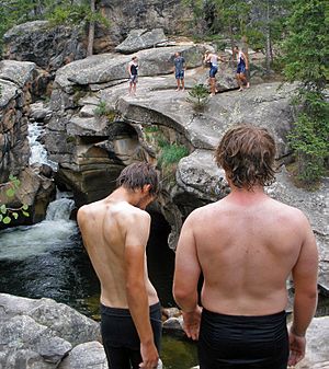
You can also enjoy water activities near the pass, especially on the Roaring Fork side. At the Grottos climbing cliffs, a short trail leads to a spot called the Devil's Punchbowl. It has high stone cliffs and waterfalls. It's a popular swimming hole because of its deep, cool water. The river is also great for fishing for trout. Some people even hike from the pass to Blue Lake to fish for lake and cutthroat trout.
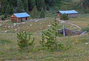
Four miles (6.4 km) west of the pass is the ghost town of Independence. This village gave the pass its name. Most of its buildings were taken apart for materials, but a few log cabins remain. The Aspen Historical Society and the U.S. Forest Service have created a special trail with signs to explain the history.
In 2011, the USA Pro Cycling Challenge bicycle race included Independence Pass. Spectators were allowed to camp at the pass. However, their impact on the environment led to a ban on camping within 10 miles (16 km) of the pass for future races. The Forest Service put up signs to remind people how fragile the tundra is.
Driving on Independence Pass
The Colorado Department of Transportation (CDOT) has rules for using Highway 82 through the pass. The most important rule is the winter closure. The road usually closes after the first big snowfall, or by November 7 at the latest. CDOT tries to reopen it just before Memorial Day weekend in late May. This is when enough snow has melted to clear the road. Sometimes, after a light winter, it reopens earlier.
Gates on both sides of the pass stop vehicles from entering when it's closed. When the road is closed, Aspen can only be reached by driving up Highway 82 from Glenwood Springs.
Even when the pass is open, not all vehicles can use it. Very large or heavy vehicles are not allowed. Also, vehicles or combinations of vehicles longer than 35 feet (11 m) are not allowed. This means big trucks, buses, and recreational vehicles (RVs) cannot use the pass.
Some truck drivers still try to use the pass. They might not know about the rules, or they might risk a fine to save time. These trucks sometimes cause accidents, which can close the pass. CDOT has put up bigger signs to warn drivers. They also work with GPS companies to make sure their maps show the restrictions. Aspen officials have suggested higher fines to stop drivers from breaking the rules.
Driving through the pass can be tricky. Both sides have steep grades of 6%, and you have to navigate hairpin turns. These turns have suggested speeds of only 10 mph (15 km/h). Rockfalls (falling rocks) can narrow parts of the road to just one lane, especially on the Aspen side. Temporary traffic lights are used in these areas. Rockfalls have also caused temporary closures on the Twin Lakes side.
Other vehicles often enter the road suddenly from parking areas for campgrounds. Many bicyclists also use Highway 82. Finally, the weather at the pass can change very quickly. Thunderstorms can happen on otherwise clear days, and it can snow any time of year. CDOT advises visitors to be ready for the high altitude and changing weather.
Independence Pass Foundation
In the past, avalanches and rockfalls often closed the highway. This was partly because building the road disturbed the land so much. In the 1930s, during the Great Depression, a group called the Civilian Conservation Corps replanted slopes near Independence village to help.
Later, as Aspen grew into a popular ski resort, the state paved the road. But the Colorado Department of Transportation (CDOT) couldn't do much more to fix the road's problems.
In 1976, Bob Lewis, an environmental activist, started replanting efforts on some damaged parts of the pass. He soon realized that a special group would be better to help the pass. So, the Independence Pass Foundation (IPF) was started in 1989. Their first project was to rebuild a curve near the Weller Lake trailhead.
This project was a success. It led to work on the "Top Cut," a 1.5-mile (2.4 km) stretch on the western side. This area had the worst erosion. Since 1996, the IPF has been building stone retaining walls and replanting the area. By the 2010s, you could see the positive results.
The IPF has also been replanting areas below the Top Cut since 2004. They use compost to add nutrients back to the soil. In 2009, the foundation started removing old metal snow fences that were put in the ground in the 1960s. These fences were ugly and bad for the environment. They had to be removed using mules and helicopters because of rules in the wilderness area. The last fence material was removed in 2012.
The IPF also works to teach people about protecting the pass's unique environment. School groups come to work and learn. Many groups "adopt" a site and work on it each year. The foundation also offers walking tours for adults that cover the pass's ecology.
Since 1994, the foundation has held a 'Ride for the Pass' bike race in May. This event helps raise money and awareness. The race is 9.5-mile (15.3 km) long, starting east of Aspen and climbing 2,500 feet (760 m) to the Independence townsite.
See also
- Colorado mountain passes
- List of mountain passes
- List of Rocky Mountain passes on the continental divide
 | Laphonza Butler |
 | Daisy Bates |
 | Elizabeth Piper Ensley |


