Independence, Pitkin County, Colorado facts for kids
Quick facts for kids |
|
|
Independence and Independence Mill Site
|
|

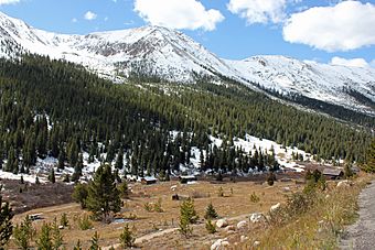
Independence and nearby mountains from SH 82, 2011
|
|
| Location | White River National Forest, CO |
|---|---|
| Nearest city | Aspen |
| Area | 40 acres (16 ha) |
| Built | 1880s |
| MPS | Mining Industry in Colorado |
| NRHP reference No. | 73000484 |
| Added to NRHP | April 11, 1973 |
Independence is a ghost town located in Pitkin County, Colorado, United States. It sits high in the mountains, about 10,913 feet (3,326 m) (3.6 km or 2.2 miles) west of Independence Pass. This was the first settlement in the Roaring Fork Valley. It was named because gold was discovered nearby on July 4, 1879.
Over time, Independence had different names for its post offices, like Farwell, Sparkill, and Chipeta. It was also known as Mammoth City, Mount Hope, and Hunter's Pass. In 1973, Independence was recognized as a historic district. It was added to the National Register of Historic Places as "Independence and Independence Mill Site."
Like other early towns in the upper Roaring Fork Valley, Independence lost people as Aspen grew. Aspen became the main business center and the county seat. Independence struggled with very harsh winters due to its high mountain location. By the end of the 1800s, most residents left after a huge snowstorm. They moved to Aspen, leaving Independence behind.
It has been a ghost town since at least 1912. The remaining buildings are mostly log cabins. They are on land partly within the White River National Forest. Independence is one of the few abandoned mining towns in Colorado that still has buildings standing. In recent years, these buildings have been fixed up. Information signs were also added for visitors.
Contents
Exploring the Independence Ghost Town Site
Independence is located about 13.5 miles (21.7 km) east of Aspen. You can find it along Colorado State Highway 82. The town sits at 10,913 feet (3,326 m) in a narrow valley. This valley is where the Roaring Fork River begins. Highway 82 passes by the town on the north side of the valley. Independence Pass is about four miles (6.4 km) east along the highway. The area around the town is open, with some wooded parts near the river.
Land Ownership and Mountain Views
The higher parts of the valley slopes are owned by the United States Forest Service. This land is part of the White River National Forest. The valley walls rise steeply on both sides. To the south is Independence Mountain, reaching 12,703 feet (3,872 m). To the north is Geissler Mountain, which is 13,301 feet (4,054 m) tall. The part of Independence closer to the river is on private land.
What Remains at the Townsite
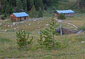
There are 26 buildings or parts of buildings remaining in a 40-acre (16 ha) area. Eight of these buildings are still standing and mostly complete. All of them are log cabins of different sizes. Some do not have roofs, and others are just foundations.
The buildings are grouped into two main areas. One area is the old townsite, and the other is the former mill. They are about 0.3 miles (480 m) apart. The townsite has 19 buildings and 9 foundations. The mill area has the remaining nine buildings. Visitors can walk around the site on a network of dirt paths.
One cabin on the west side of the site has been fully fixed up. It is now a modern home. This cabin is called the Intern Cabin. It used to house a person who lived there in the summers. This person would maintain the site and give tours to visitors. Another large cabin is thought to have been one of the town's general stores. Further west, near Highway 82, are the remains of the Farwell Mill. You can still see some of its supporting timbers.
The Story of Independence: A Gold Rush Town
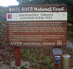
In 1879, gold seekers traveled west from Leadville. They went over the mountains and into the Roaring Fork Valley. They had heard stories of huge amounts of gold there. On July 4, 1879, miners found gold at a small camp. They named their gold claim "Independence" after the holiday. Soon, a small tent city grew up at the site.
News reached Leadville, where some miners had left due to conflicts with the Ute Native American tribe. The Colorado governor had even ordered settlers not to cross the mountains. Despite this order, more settlers came to Independence. It became the first European settlement in the valley. The miners created a simple government. This helped protect their gold claims.
Growth and Prosperity of Independence
By 1880, Independence had 150 people. Permanent buildings started to replace the tents. Two other camps were also set up further down the valley. These were Ute City (later Aspen) and Ashcroft. In 1881, a company called Farwell Consolidated Mining Company bought all the gold claims. They built a mill to process gold and a sawmill. A stage road was built from Leadville over the mountains. This road was the start of Highway 82. The trip to other mining towns took 2 to 5 days. So, Independence also became a stop where travelers could stay overnight.
Two years after gold was first found, Independence was a busy mining town. It had 500 residents. There were seven restaurants, 24 stores, and three saloons. The town even had its own newspaper called the Miner. Over the next two years, Farwell's mines produced $190,000 worth of gold. This would be worth a lot more money today.
The Decline of Independence
Even with its success, Independence lost its chance to be the main town of the new Pitkin County. That honor went to Ute City, which was renamed Aspen. Aspen was named for the many aspen trees in the area. Independence continued to grow for a short time. In 1882, it had 1,500 residents, 47 businesses, five saloons, and two boarding houses.
However, 1882 was the peak of Independence's "boom" period. Gold production dropped sharply in 1883. Most of the easy-to-find gold was gone. Miners and other residents began to leave Independence for Aspen. Aspen offered more jobs because it had several mining companies. These companies were supported by rich investors from the East. Aspen's mines produced silver, which the government was required to buy. Aspen also had milder weather. Independence was covered in heavy snow from late October to mid-May every year. Even today, Highway 82 closes during these months, making Independence unreachable by car.
By 1888, the town's population had fallen to 150 people. Later that year, the first railroads reached Aspen. This greatly reduced the stagecoach traffic over the mountains. This was another blow to Independence's economy. In 1893, the government stopped buying silver. This caused problems for Aspen's silver mines and made it even harder for Independence to survive.
The Final Evacuation
Finally, in the winter of 1899, seven big snowstorms cut the town off. Residents ran out of food and supplies. When another severe storm hit, almost everyone decided to leave. They took the wooden planks from their houses. They used these planks like cross-country skis to travel down the valley to Aspen. They even made a joke about their escape, calling it the "Hunter Pass Tenderfoot Snowshoe Club Race." The entry fee was one ham sandwich per person.
They never returned to Independence. Although there was a small return of gold prospecting in 1907–08, the town was completely empty by 1912. That year, the Farwell Stamp Mill caught fire. Most of what was left was taken by people to use as building materials elsewhere. The buildings were left to fall apart. However, some mining claims in the area remained active for many years.
Preserving Independence's History
During its heavy winters, the site was always at risk from avalanches. This was especially true on the south side of the valley, where trees had been cut down for mining. In the 1930s, the Colorado Women's Club started a project. They used workers from the Civilian Conservation Corps to replant trees on the slopes. This helped stop the avalanche danger. This was the first effort to preserve Independence.
Later, after Independence was listed on the National Register, groups like the Aspen Historical Society worked with the U.S. Forest Service. They helped restore the log cabins. They also built the path network and added information signs. They even paid for an intern to live there during the summer months. This intern would help maintain the site and give tours to visitors.
 | Misty Copeland |
 | Raven Wilkinson |
 | Debra Austin |
 | Aesha Ash |


