
La Plata Peak facts for kids
Quick facts for kids La Plata Peak |
|
|---|---|
 |
|
| Highest point | |
| Elevation | 14,361 ft (4372 m) NAVD88 |
| Prominence | 1836 ft (560 m) |
| Isolation | 6.28 mi (10.11 km) |
| Listing |
|
| Geography | |

La Plata Peak
Location in Colorado
|
|
| Location | Chaffee County, Colorado, U.S. |
| Parent range | Sawatch Range, Collegiate Peaks |
| Topo map | USGS 7.5' topographic map Mount Elbert, Colorado |
| Climbing | |
| First ascent | July 26, 1873 Hayden Survey |
| Easiest route | Northwest Ridge or Southwest Ridge: Hike (class 2) |
La Plata Peak is a very tall mountain in Colorado, United States. It's one of the highest peaks in the Rocky Mountains of North America. This mountain stands at 14,361 feet (4,372 meters) high.
It is known as a "fourteener" because it is over 14,000 feet tall. La Plata Peak is the fourth-highest fourteener in Colorado. It is located in the Collegiate Peaks Wilderness. This area is part of the San Isabel National Forest. The mountain is about 36.5 kilometers (22.7 miles) northwest of the Town of Buena Vista.
Contents
What's in a Name?
The name "La Plata" comes from the Spanish language. It means "The Silver." This name was chosen because there used to be a lot of silver in the area.
In the early 1900s, there were towns nearby that mined for silver. These were the towns of Winfield and Hamilton. They are now ghost towns, meaning they are abandoned.
A team of explorers first climbed La Plata Peak a long time ago. This was on July 26, 1873. The team was part of the Hayden Survey.
Climbing La Plata Peak
There are a few ways to climb La Plata Peak. Two routes are used most often by hikers.
Southern Route
One path starts near the old town of Winfield. This is to the south of the peak. Hikers climb north into a large, wet area. This area is about 12,000 feet high.
From there, the trail gets much steeper. It goes up a rocky wall to about 13,000 feet. After climbing this wall, it's a short rock scramble to reach the very top.
Northern Route
Another way to reach the summit is from the north. This trail begins from Highway 82. It follows a ridge that separates two areas: the La Plata basin and La Plata Gulch.
Challenging Climb
There is also a much harder way to climb the peak. This route is called Ellingwood Ridge. It is on the northeast side of the mountain. This is a very tough climb, known as a Class 4 climb. It involves gaining 6,000 feet in height.
Images for kids
-
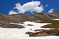
Hikers near La Plata Peak summit

See also
 In Spanish: Pico La Plata para niños
