Capitol Peak (Colorado) facts for kids
Quick facts for kids Capitol Peak |
|
|---|---|

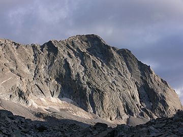
Capitol Peak, from Capitol Lake
|
|
| Highest point | |
| Elevation | 14,137 ft (4309 m) NAVD88 |
| Prominence | 1750 ft (533 m) |
| Isolation | 7.44 mi (11.98 km) |
| Listing |
|
| Geography | |
| Location | Pitkin County, Colorado, U.S. |
| Parent range | Elk Mountains |
| Topo map | USGS 7.5' topographic map Capitol Peak, Colorado |
| Climbing | |
| First ascent | 1909 by Percy Hagerman and Harold Clark |
| Easiest route | Northeast Knife RidgeScramble, class 4 |
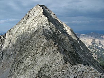
Capitol Peak is a very tall and well-known mountain in the Elk Mountains. This mountain range is part of the larger Rocky Mountains in North America. Capitol Peak is the 52nd highest mountain on the continent.
Standing at 14,137-foot (4,309 m), it's one of Colorado's famous "fourteeners" (mountains over 14,000 feet). You can find it in the Maroon Bells-Snowmass Wilderness area of White River National Forest. It's about 8.7 miles (14.0 km) east of Redstone in Pitkin County, Colorado, United States.
Contents
Exploring Capitol Peak Mountain
Capitol Peak is part of a long ridge that connects the main Elk Mountains to Mount Sopris. It's impressive because it rises almost 9,000 feet above the Roaring Fork Valley below.
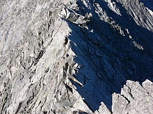
Climbing Capitol Peak is known to be one of the toughest challenges among Colorado's fourteeners. The easiest way up, called the Northeast Ridge, involves crossing a very narrow and exposed path known as the "Knife Edge." This part of the climb requires extreme caution.
Other climbing paths on Capitol Peak need special rock climbing skills. For example, the Northwest Buttress Route is a difficult climb (Grade IV, Class 5.9). These routes can have loose rocks, which means rocks might fall. However, the rocks on Capitol Peak are generally more stable than on the famous Maroon Bells or Pyramid Peak.
Hiking the Capitol Peak Trail
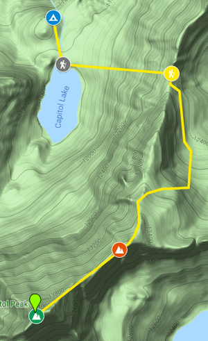
The Capitol Peak trail is a 15.1-mile round trip. It's located near Snowmass Village, Colorado. This trail has a lake and is only suggested for very experienced hikers and climbers. People mostly use this trail for hiking, rock climbing, and backpacking. The best time to go is from July to September. Dogs are also allowed on this trail.
From the parking lot, you'll hike about 5.7 miles to reach the Capitol Peak campsite. After that, it's another 1.9 miles to K2 and then to the summit. K2 is a smaller peak that hikers sometimes confuse with the actual Capitol Peak summit.
Camping on Capitol Peak
You can find simple camping spots near the start of the trail in a special area. You don't need to pay a fee, but there might be some rules to follow.
Daly Pass
At the start of the trail, at an altitude of 9,400 feet, you'll follow several turns for half a mile to reach Daly Pass. This pass is the first important spot on the Capitol Peak trail. It's known for its saddle-shaped ridge, which reaches 12,480 feet high. After Daly Pass, the hike becomes much more challenging until you reach the summit.
K2 Peak
K2 is a peak that hikers often mistake for the true Capitol Peak summit. Most hikers try to go around the right side of K2, which is very exposed (meaning there are steep drops). It's important to be very careful here.
The Knife Edge
The Knife Edge (shown in the picture above) is famous for being 150 feet long. It has steep drops of 2,000 feet on both sides! Some very brave climbers walk across it quickly. Other hikers might carefully scoot across it, like straddling a horse. This part of the trail requires extreme caution due to its exposure.
Capitol Peak Summit Views
From the very top of Capitol Peak, you can see the Pierre Lakes in a huge bowl-shaped area to the east. To the south, you'll see Snowmass Mountain, another "fourteener," at the end of a long, broken ridge. Further east, you can spot red-striped peaks, including the Maroon Bells, Pyramid Peak, and Castle Peak. The long ridge of the Continental Divide is also visible to the east.
Capitol Peak Climate
This table shows the average weather conditions each month on Capitol Peak. It includes how warm or cold it gets and how much rain or snow falls.
| Month | Average High | Average Low | Average Precipitation | Average Snow |
|---|---|---|---|---|
| January | 27 F | -2 F | 3.51 in | 50.1 in |
| February | 30 F | -1 F | 2.46 in | 39.6 in |
| March | 36 F | 7 F | 3.97 in | 58.8 in |
| April | 42 F | 12 F | 3.48 in | 45.1 in |
| May | 51 F | 22 F | 1.96 in | 20.6 in |
| June | 63 F | 30 F | 1.11 in | 3.8 in |
| July | 68 F | 35 F | 2.23 in | 0 in |
| August | 66 F | 34 F | 1.91 in | 0 in |
| September | 57 F | 29 F | 1.70 in | 4.9 in |
| October | 47 F | 20 F | 1.76 in | 20.3 in |
| November | 34 F | 7 F | 2.72 in | 43.0 in |
| December | 27 F | 0 F | 3.02 in | 50.8 in |
| Yearly Average | 46 F (Rounded) | 16 F (Rounded) | 2.49 in (Rounded) | 28.1 in (Rounded) |
Historical Names of Capitol Peak
- Capital Peak
- Capitol Peak - This name was given by the Hayden Survey team. They thought the mountain looked a lot like the U.S. Capitol building.
 | Roy Wilkins |
 | John Lewis |
 | Linda Carol Brown |


