
Mount Sopris facts for kids
Quick facts for kids Mount Sopris West Peak |
|
|---|---|

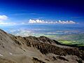
Mount Sopris as viewed from State Highway 82.
|
|
| Highest point | |
| Elevation | 12,965 ft (3,952 m) |
| Prominence | 1,453 ft (443 m) |
| Isolation | 9.23 mi (14.85 km) |
| Geography | |

Mount Sopris West Peak
Location in Colorado
|
|
| Location | Pitkin County, Colorado, U.S. |
| Parent range | Elk Mountains |
| Topo map | USGS 7.5' topographic map Mount Sopris, Colorado |
| Climbing | |
| Easiest route | Mount Sopris Trail (hike) |
| Mount Sopris East Peak | |
|---|---|
| Highest point | |
| Elevation | 12,965 ft (3,952 m) |
Mount Sopris is a special mountain with two peaks in the Elk Mountains. These mountains are part of the larger Rocky Mountains in North America. Mount Sopris stands tall at 12,965 feet (3,952 meters). It is found in the Maroon Bells-Snowmass Wilderness area, which is part of the White River National Forest. The mountain is about 6.6 miles (10.7 km) north of Redstone in Pitkin County, Colorado, United States.
Contents
What Makes Mount Sopris Special?
Mount Sopris is located in western Pitkin County. It is south of Carbondale. The mountain is also southwest of where the Crystal River and Roaring Fork River meet.
Twin Peaks of Mount Sopris
A cool fact about Mount Sopris is that it has two main peaks. They are called East Sopris and West Sopris. These two peaks are only about half a mile (0.8 km) apart. Even more interesting, they are both the exact same height: 12,965 feet!
Who Was Mount Sopris Named After?
The mountain is named after Richard Sopris. He was a former mayor of Denver, Colorado. Richard Sopris was also part of the first European group to explore the Roaring Fork Valley. In 2011, there was a suggestion to rename East Sopris to "Mount John Denver" after the famous Colorado singer. However, most local people did not support this idea. A poll showed that 74 percent of people in Aspen and Carbondale were against the name change.
How Was Mount Sopris Formed?
Scientists believe Mount Sopris was formed deep underground. About 30 million years ago, hot, melted rock (magma) pushed up into the Earth's crust. This created a large body of rock called a pluton. This happened after the Rocky Mountains first started to rise.
Mount Sopris is not a volcano today. It's possible that a very old volcano once sat above it. But if so, all signs of it have been worn away by weather over millions of years. The rock we see today on Mount Sopris never reached the surface as lava. Instead, it cooled and hardened slowly underground. Later, erosion wore away the softer rock above it, revealing the hard rock of Mount Sopris. Other nearby peaks, like Mount Gunnison and Crested Butte, likely formed in a similar way.
Mount Sopris: A Local Landmark
Mount Sopris is a very important symbol for the area. It stands out in the skyline of Carbondale and the lower Roaring Fork Valley. You can see it clearly from State Highway 82 near Carbondale. It is one of the tallest peaks in Colorado when you compare its height to the valley below. For example, West Sopris rises 6,400 feet (1,905 meters) above the valley in just 2.7 miles (4 km). This is a huge and impressive rise in such a short distance!
Hiking and Climbing Mount Sopris
If you like adventure, you can hike to East Sopris using the Mount Sopris Trail. This trail starts near Dinkle Lake, on the northeast side of the mountain. It passes between the two Thomas Lakes before reaching the tree line.
What to Expect on the Trail
The hike involves climbing about 4,300 feet (1,300 meters) in height. The round trip is about 12 miles (20 km) long. If you want to visit West Sopris too, that adds another 600 feet (180 meters) of climbing and 1 mile (1.6 km) of hiking. It is a challenging hike, and some parts of the trail have loose rocks, called scree.
Historical Names of Mount Sopris
- Mount Sopris (current name)
- Sopris Peak
Images for kids
-
Looking North West from Mt. Sopris

