Garfield County, Colorado facts for kids
Quick facts for kids
Garfield County
|
||
|---|---|---|

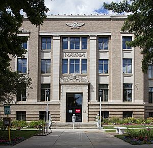
Garfield County Courthouse in Glenwood Springs
|
||
|
||
| Motto(s):
"New Energy in the Wild West"
|
||

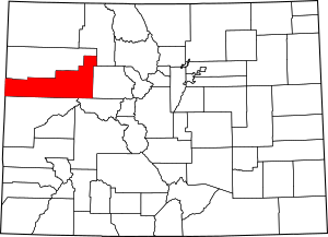
Location within the U.S. state of Colorado
|
||
 Colorado's location within the U.S. |
||
| Country | ||
| State | ||
| Founded | February 10, 1883 | |
| Named for | James A. Garfield | |
| Seat | Glenwood Springs | |
| Largest city | Rifle | |
| Area | ||
| • Total | 2,956 sq mi (7,660 km2) | |
| • Land | 2,948 sq mi (7,640 km2) | |
| • Water | 8.3 sq mi (21 km2) 0.3%% | |
| Population
(2020)
|
||
| • Total | 61,685 | |
| • Estimate
(2023)
|
62,707 |
|
| • Density | 20.868/sq mi (8.0571/km2) | |
| Time zone | UTC−7 (Mountain) | |
| • Summer (DST) | UTC−6 (MDT) | |
| Congressional district | 3rd | |
Garfield County is a county in the state of Colorado, USA. It's a place where many people live, work, and go to school. In 2020, about 61,685 people called Garfield County home. The main town, or county seat, is Glenwood Springs.
This county got its name from James A. Garfield, who was a U.S. President. It's part of a larger area that includes Glenwood Springs and nearby towns, making it an important region in Colorado.
Contents
Exploring Garfield County's Geography
Garfield County is quite large! It covers about 2,956 square miles. Most of this area is land, with a small part being water, like rivers and lakes.
Neighboring Counties and States
Garfield County shares its borders with several other counties in Colorado and even two counties in Utah:
- Rio Blanco County (to the north)
- Routt County (to the northeast)
- Eagle County (to the east)
- Pitkin County (to the southeast)
- Mesa County (to the south)
- Grand County, Utah (to the southwest)
- Uintah County, Utah (to the northwest)
Main Roads and Travel Routes
Many important roads help people travel through Garfield County:
 Interstate 70: A major highway that crosses the county.
 I-70 Bus. and
  I-70 Bus.: Business loops of Interstate 70 in Rifle and Silt.
 U.S. Highway 6
 State Highway 13
 State Highway 82
 State Highway 133
 State Highway 139
 State Highway 325
Nature and Protected Areas
Garfield County is home to beautiful natural spots where you can explore and enjoy the outdoors:
- Flat Tops Wilderness
- Grand Mesa National Forest
- Harvey Gap State Park
- Rifle Falls State Park
- Rifle Gap State Park
- Routt National Forest
- White River National Forest
Scenic Drives and Byways
If you like road trips, Garfield County has some amazing scenic routes:
- Dinosaur Diamond Prehistoric Highway National Scenic Byway
- Flat Tops Trail Scenic Byway
- West Elk Loop Scenic Byway
People and Population (Demographics)
The number of people living in Garfield County has grown a lot over the years.
| Historical population | |||
|---|---|---|---|
| Census | Pop. | %± | |
| 1890 | 4,478 | — | |
| 1900 | 5,835 | 30.3% | |
| 1910 | 10,144 | 73.8% | |
| 1920 | 9,304 | −8.3% | |
| 1930 | 9,975 | 7.2% | |
| 1940 | 10,560 | 5.9% | |
| 1950 | 11,625 | 10.1% | |
| 1960 | 12,017 | 3.4% | |
| 1970 | 14,821 | 23.3% | |
| 1980 | 22,514 | 51.9% | |
| 1990 | 29,974 | 33.1% | |
| 2000 | 43,791 | 46.1% | |
| 2010 | 56,389 | 28.8% | |
| 2020 | 61,685 | 9.4% | |
| 2023 (est.) | 62,707 | 11.2% | |
| U.S. Decennial Census 1790-1960 1900-1990 1990-2000 2010-2020 |
|||
In 2010, about 56,389 people lived here. By 2020, the population grew to 61,685. This shows that more and more people are choosing to live in Garfield County.
Learning and Education
Garfield County has a strong focus on education, with several public and private schools.
Public Schools
The county is divided into three main school districts:
- Roaring Fork School District RE-1: Serves students in Glenwood Springs, Carbondale, and Basalt.
- Garfield County School District RE-2: Covers schools in Rifle, New Castle, and Silt.
- Garfield County School District 16: Provides education for students in Parachute and Battlement Mesa.
Private Schools
There are also private schools available, such as:
- Colorado Rocky Mountain School in Carbondale.
- St. Stephen Catholic School in Glenwood Springs.
- Liberty Classical Academy in New Castle.
Higher Education Opportunities
For students looking to continue their education after high school, Garfield County is home to several campuses of Colorado Mountain College. This college offers many programs and has a main campus at Spring Valley, near Glenwood Springs. Other campuses are in Glenwood Springs, Rifle, and Carbondale.
Working and Economy
The economy in Garfield County is supported by many different businesses and organizations.
Major Employers in the County
Here are some of the largest employers in Garfield County, providing many jobs for residents:
| # | Employer | Number of Employees |
|---|---|---|
| 1 | Valley View Hospital | 1,000 - 1,250 |
| 2 | Roaring Fork School District RE-1 | 500 - 999 |
| 3 | Garfield County School District RE-2 | 500 - 999 |
| 4 | Grand River Hospital | 500 - 999 |
| 5 | City Market | 500 - 999 |
| 6 | Garfield County | 250 - 499 |
| 7 | Colorado Mountain College | 250 - 499 |
| 8 | Walmart | 250 - 499 |
| 9 | City of Glenwood Springs | 200 - 499 |
| 10 | Alpine Bank | 100 - 249 |
Towns and Communities
Garfield County has several cities, towns, and other communities where people live.
Cities in Garfield County
- Glenwood Springs (the county seat)
- Rifle
Towns in Garfield County
- Carbonate (a ghost town, meaning it's abandoned)
- Carbondale
- New Castle
- Parachute
- Silt
Census-Designated Places (CDPs)
These are areas that are like towns but are not officially incorporated as cities or towns:
See also
 In Spanish: Condado de Garfield (Colorado) para niños
 | Frances Mary Albrier |
 | Whitney Young |
 | Muhammad Ali |


