Silt, Colorado facts for kids
Quick facts for kids
Silt, Colorado
|
|
|---|---|

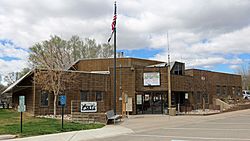
Silt Town Hall.
|
|

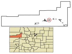
Location of Silt in Garfield County, Colorado.
|
|
| Country | |
| State | |
| County | Garfield County |
| Incorporated | May 1915 |
| Government | |
| • Type | Statutory Town |
| Area | |
| • Total | 1.73 sq mi (4.47 km2) |
| • Land | 1.66 sq mi (4.29 km2) |
| • Water | 0.07 sq mi (0.18 km2) |
| Elevation | 5,456 ft (1,663 m) |
| Population
(2020)
|
|
| • Total | 3,536 |
| • Density | 2,044/sq mi (791.1/km2) |
| Time zone | UTC-7 (Mountain (MST)) |
| • Summer (DST) | UTC-6 (MDT) |
| ZIP code |
81652
|
| Area code(s) | 970 |
| FIPS code | 08-70195 |
| GNIS feature ID | 2413284 |
Silt is a small town located in Garfield County, Colorado, in the United States. It's called a "statutory town" because it follows rules set by the state of Colorado. In 2020, about 3,536 people lived there. This was more than the 2,930 people who lived there in 2010. Silt is also part of the larger area around Glenwood Springs.
Contents
History of Silt
Silt got its name from the type of soil found there. The word "silt" means fine sand, clay, or other material carried by moving water and then left as a deposit. The town's first post office opened in 1898. Silt officially became a town in May 1915.
Geography and Location
Silt is located on the north side of the Colorado River. It is about 175 miles (282 km) west of Denver, Colorado's capital city. The main highway, Interstate 70, goes through Silt, making it easy to get there from Exit 97.
The town of Glenwood Springs, which is the county seat, is about 19 miles (31 km) to the east. The town of Rifle is about 7 miles (11 km) to the west. U.S. Route 6 is the main street in Silt and runs parallel to Interstate 70.
According to the United States Census Bureau, Silt covers a total area of about 1.73 square miles (4.47 square kilometers). A small part of this area, about 0.07 square miles (0.18 square kilometers), is water.
Silt's Climate
Silt has a type of weather called a humid continental climate. This means the town experiences big changes in temperature throughout the year. Summers are usually warm to hot, and sometimes humid. Winters are cold, and can even be very cold.
| Climate data for Silt, Colorado | |||||||||||||
|---|---|---|---|---|---|---|---|---|---|---|---|---|---|
| Month | Jan | Feb | Mar | Apr | May | Jun | Jul | Aug | Sep | Oct | Nov | Dec | Year |
| Mean daily maximum °C (°F) | 3 (37) |
7 (44) |
12 (54) |
18 (64) |
23 (74) |
29 (84) |
32 (90) |
31 (88) |
26 (79) |
19 (67) |
11 (51) |
4 (39) |
18 (64) |
| Mean daily minimum °C (°F) | −13 (9) |
−8 (17) |
−4 (24) |
−1 (31) |
4 (39) |
7 (45) |
11 (52) |
10 (50) |
5 (41) |
−1 (31) |
−6 (21) |
−11 (12) |
−1 (31) |
| Average precipitation mm (inches) | 23 (0.9) |
20 (0.8) |
23 (0.9) |
25 (1) |
25 (1) |
18 (0.7) |
25 (1) |
28 (1.1) |
28 (1.1) |
30 (1.2) |
23 (0.9) |
23 (0.9) |
290 (11.6) |
| Source: Weatherbase | |||||||||||||
Population Changes Over Time
The number of people living in Silt has grown quite a bit over the years. Here's how the population has changed according to the U.S. Decennial Census:
| Historical population | |||
|---|---|---|---|
| Census | Pop. | %± | |
| 1920 | 165 | — | |
| 1930 | 264 | 60.0% | |
| 1940 | 359 | 36.0% | |
| 1950 | 361 | 0.6% | |
| 1960 | 384 | 6.4% | |
| 1970 | 434 | 13.0% | |
| 1980 | 923 | 112.7% | |
| 1990 | 1,095 | 18.6% | |
| 2000 | 1,740 | 58.9% | |
| 2010 | 2,930 | 68.4% | |
| 2020 | 3,536 | 20.7% | |
| U.S. Decennial Census | |||
Education in Silt
Students in Silt attend schools that are part of the Garfield Re-2 School District. The town has its own elementary school called Cactus Valley Elementary School. For middle school and high school, students go to Riverside Middle School and Coal Ridge High School. Both of these schools are located in the nearby town of New Castle.
See also
 In Spanish: Silt (Colorado) para niños
 | Kyle Baker |
 | Joseph Yoakum |
 | Laura Wheeler Waring |
 | Henry Ossawa Tanner |

