
Rifle, Colorado facts for kids
Quick facts for kids
Rifle, Colorado
|
|
|---|---|

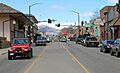
Railroad Avenue in Rifle looking north.
|
|

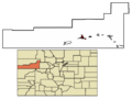
Location in Garfield County and Colorado
|
|

Rifle, Colorado
Location in the United States
|
|
| Country | |
| State | |
| County | Garfield County |
| City | Rifle |
| Founded | 1882 |
| Incorporated | August 18, 1905 |
| Founded by | Abram Maxfield |
| Named for | Rifle Creek |
| Government | |
| • Type | Home rule municipality |
| Area | |
| • Total | 7.15 sq mi (18.53 km2) |
| • Land | 7.03 sq mi (18.22 km2) |
| • Water | 0.12 sq mi (0.31 km2) |
| Elevation | 5,519 ft (1,682 m) |
| Population
(2020)
|
|
| • Total | 10,437 |
| • Density | 1,379.87/sq mi (532.75/km2) |
| Time zone | UTC-7 (Mountain (MST)) |
| • Summer (DST) | UTC-6 (MDT) |
| ZIP code |
81650
|
| Area code(s) | 970 |
| FIPS code | 08-64255 |
| GNIS feature ID | 2410947 |
Rifle is a town in Garfield County, Colorado, United States. It is the largest community in the county. In 2020, about 10,437 people lived there. Rifle is an important center for cattle ranching. It is located along Interstate 70 and the Colorado River. The town sits just east of the Roan Plateau, which is a large flat-topped mountain that can be seen from Rifle.
Abram Maxfield founded Rifle in 1882. It became an official town in 1905. The town is named after Rifle Creek, a stream that flows into the Colorado River nearby.
Contents
Exploring Rifle's Past
The area where Rifle is now was once home to the Ute people. They are a group of Native American people. The Tabagauche tribe of the Ute people lived and hunted in the area, especially in the Roaring Fork Valley to the east. Because of their location, their way of life changed less than other tribes when white settlers arrived.
In 1878, a man named Nathan Meeker became the leader of the White River Ute Agency. This agency worked with the Ute people. The town of Meeker, Colorado is named after him. Nathan Meeker did not understand Ute culture well. He tried to make them farm and go to European-American schools. This was very different from the Ute's nomadic (traveling) lifestyle, so they resisted.
Things became very tense when Meeker plowed over the Ute's horse pasture and racetrack. This led to a conflict in 1879, sometimes called the Meeker Massacre. Meeker and ten of his workers were killed. After this, most of the Ute people were forced to leave Colorado and move to eastern Utah. This happened even though the U.S. government had promised them the land they were living on.
Railroad and Ranching Growth
As the 1800s ended and the 1900s began, more people settled in Rifle. In 1889, the railroad reached Rifle from the east. For a while, Rifle was the end of the line before more tracks were built. This brought many new travelers, settlers, and goods to the town. It became much easier to ship cattle and other products. Rifle became a busy center for trade.
The first big industry in Rifle was ranching. The land around the town was dry, and much of it needed irrigation (watering systems) to grow crops. Even with lots of land, there were disagreements between cattle ranchers and sheep herders. There were not good rules for grazing (letting animals eat grass). The summer pastures on top of the Roan Plateau were often fought over. One story tells of a rancher who lost many sheep when cowboys from a rival ranch drove them off a cliff.
Energy Resources and the Economy
Rifle is located in the eastern part of the Piceance Basin. This area has different types of fossil fuels, especially oil shale. Oil shale is a rock that contains oil, but it can be hard to get the oil out. Because of this, Rifle's economy has often gone through "boom and bust" cycles. This means periods of fast growth followed by slow times, depending on how much oil and gas are being produced.
Since 2007, a group called the Campaign to Save Roan Plateau has worked to reduce oil and gas drilling on the Roan Plateau. Locals often call this area the Book Cliffs. You can reach the Roan Plateau from the JQS Trail, which is about 3 miles (5 km) north of Rifle.
Rifle's Location and Landscape
Rifle is in the valley of the Colorado River. Rifle Creek joins the Colorado River from the north here. Most of the town is on the north side of the river, but some parts are to the south.
Interstate 70 runs through Rifle along the south side of the river. You can get on or off I-70 at Exit 90. Going east on I-70, it's about 26 miles (42 km) to Glenwood Springs, Colorado, which is the main town in Garfield County. Going southwest, it's about 60 miles (97 km) to Grand Junction, Colorado. U.S. Route 6 also goes through Rifle on the north side of the Colorado River. It's a local road that runs parallel to I-70. Colorado State Highway 13 crosses I-70 and US-6. It goes through the southern and western parts of Rifle, then heads north about 41 miles (66 km) to Meeker, Colorado.
The United States Census Bureau says that Rifle covers a total area of about 7.15 square miles (18.53 km²). Most of this area, about 7.03 square miles (18.22 km²), is land. A small part, about 0.12 square miles (0.31 km²), is water.
Weather in Rifle
Rifle has a climate with warm summers and cold winters. Here are some average temperatures and rainfall:
| Climate data for Rifle, 1991-2020 normals | |||||||||||||
|---|---|---|---|---|---|---|---|---|---|---|---|---|---|
| Month | Jan | Feb | Mar | Apr | May | Jun | Jul | Aug | Sep | Oct | Nov | Dec | Year |
| Record high °F (°C) | 62 (17) |
69 (21) |
81 (27) |
92 (33) |
99 (37) |
102 (39) |
104 (40) |
102 (39) |
99 (37) |
88 (31) |
79 (26) |
65 (18) |
104 (40) |
| Mean daily maximum °F (°C) | 36.8 (2.7) |
43.5 (6.4) |
55.4 (13.0) |
62.9 (17.2) |
74.3 (23.5) |
86.4 (30.2) |
92.1 (33.4) |
88.9 (31.6) |
80.0 (26.7) |
65.5 (18.6) |
49.7 (9.8) |
37.3 (2.9) |
64.4 (18.0) |
| Mean daily minimum °F (°C) | 13.4 (−10.3) |
19.8 (−6.8) |
27.0 (−2.8) |
32.6 (0.3) |
40.2 (4.6) |
47.9 (8.8) |
55.3 (12.9) |
53.6 (12.0) |
45.0 (7.2) |
33.6 (0.9) |
23.3 (−4.8) |
14.0 (−10.0) |
33.8 (1.0) |
| Record low °F (°C) | −38 (−39) |
−34 (−37) |
−16 (−27) |
4 (−16) |
17 (−8) |
22 (−6) |
33 (1) |
31 (−1) |
21 (−6) |
7 (−14) |
−16 (−27) |
−27 (−33) |
−38 (−39) |
| Average precipitation inches (mm) | 0.70 (18) |
0.60 (15) |
0.76 (19) |
1.01 (26) |
1.14 (29) |
0.68 (17) |
0.96 (24) |
1.07 (27) |
1.34 (34) |
1.27 (32) |
0.63 (16) |
0.57 (14) |
10.73 (271) |
| Source 1: weather.com | |||||||||||||
| Source 2: xmACIS2 | |||||||||||||
People Living in Rifle
| Historical population | |||
|---|---|---|---|
| Census | Pop. | %± | |
| 1900 | 273 | — | |
| 1910 | 698 | 155.7% | |
| 1920 | 865 | 23.9% | |
| 1930 | 1,287 | 48.8% | |
| 1940 | 1,373 | 6.7% | |
| 1950 | 1,525 | 11.1% | |
| 1960 | 2,135 | 40.0% | |
| 1970 | 2,150 | 0.7% | |
| 1980 | 3,215 | 49.5% | |
| 1990 | 4,636 | 44.2% | |
| 2000 | 6,784 | 46.3% | |
| 2010 | 9,172 | 35.2% | |
| 2020 | 10,437 | 13.8% | |
| U.S. Decennial Census | |||
In 2010, there were 9,172 people living in Rifle. There were 3,221 households and 2,230 families. About 40% of households had children under 18.
The population was spread out by age:
- 30.6% were under 18 years old.
- 9.2% were 18 to 24 years old.
- 34.4% were 25 to 44 years old.
- 17.1% were 45 to 64 years old.
- 8.5% were 65 years or older.
The average age was 31 years.
Fun Things to Do in Rifle
.jpg)

Rifle has many outdoor activities and attractions nearby.
- Rifle Mountain Park is about 16 miles (26 km) north of Rifle. The city maintains this park. It is very popular with rock climbers because of its cliffs.
- Rifle Falls State Park is a beautiful place with waterfalls.
- Rifle Falls Fish Hatchery is where fish are raised.
- Rifle Gap State Park and Harvey Gap State Park offer chances for boating, fishing, and camping.
- You can also explore land managed by the BLM. This includes Hubbard Mesa Open Area, Rifle Arch, and the Roan Plateau.
For golf lovers, there's the Rifle Creek Golf Course. It's located about 6 miles (10 km) north of the city center.
In 2014, the New Ute Theater opened in downtown Rifle. It's a place for entertainment and shows.
Rifle is also home to the Garfield County Fair Grounds. Once a year, the city gets very busy with the Garfield County Fair. This event includes family and professional rodeos, Xtreme bull riding, live music, and a demolition derby.
Learning in Rifle
Rifle is part of the Garfield Re-2 School District. The city has several schools for students:
- Graham Mesa Elementary School
- Highland Elementary School
- Wamsley Elementary School
- Rifle Middle School
- Rifle High School
For students who want to continue their education after high school, Colorado Mountain College has a campus in Rifle.
Getting Around Rifle
Rifle has its own airport, the Garfield County Regional Airport. The state bus service, Bustang, connects Rifle to Grand Junction, Colorado and Denver. The city is also on the Union Pacific/Rio Grande train line, which runs between Denver and Ogden.
Famous People from Rifle
- David Bernhardt: He used to be the United States Secretary of the Interior, a high-ranking government official.
- Lauren Boebert: She is a U.S. Representative, meaning she represents the area in the national government.
- Bo Nickal: A talented freestyle wrestler and mixed martial artist.
Images for kids
-
Railroad Avenue in Rifle looking north.
-
Location in Garfield County and Colorado
-
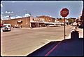
Rifle, 1973
-
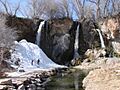
Rifle Falls State Park, north of Rifle
-
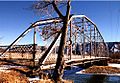
Rifle Bridge in winter on the Colorado River. The bridge, built in 1909, is now closed to traffic and is listed on the National Register of Historic Places.
.jpg)
See also
 In Spanish: Rifle (Colorado) para niños
