Grand Junction, Colorado facts for kids
Quick facts for kids
Grand Junction, Colorado
|
|
|---|---|
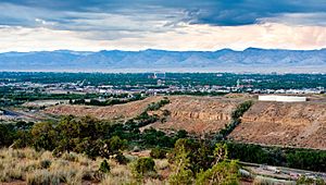
Grand Junction skyline
|
|
| Nicknames:
Colorado Wine Country, River City
|
|
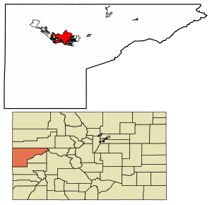
Location of Grand Junction in Mesa County, Colorado
|
|
| Country | |
| State | |
| County | Mesa |
| Incorporated | July 22, 1882 |
| Named for | Confluence of Grand River and Gunnison River |
| Government | |
| • Type | Council-Manager |
| Area | |
| • Total | 40.077 sq mi (103.799 km2) |
| • Land | 39.634 sq mi (102.652 km2) |
| • Water | 0.443 sq mi (1.147 km2) |
| Elevation | 4,646 ft (1,416 m) |
| Population
(2020)
|
|
| • Total | 65,560 |
| • Estimate
(2025)
|
71,780 |
| • Rank | 17th in Colorado |
| • Density | 1,654/sq mi (639/km2) |
| • Metro | 155,703 |
| Time zone | UTC−07:00 (MST) |
| • Summer (DST) | UTC−06:00 (MDT) |
| ZIP Codes |
81501–81507
|
| Area code(s) | 970/748 |
| FIPS code | 08-31660 |
| GNIS feature ID | 2410631 |
| Highways | I-70, U.S. Highway 6, U.S. Highway 50, CO SH 340, CO SH 141, CO SH 139 |
Grand Junction is a city in Colorado, United States. It is the largest city and the county seat of Mesa County, Colorado. A county seat is like the main town for a county's government.
In 2020, Grand Junction had a population of 65,560 people. This makes it the biggest city in western Colorado. It is also the 17th most populated city in all of Colorado.
Grand Junction is the main center for business and culture in the Western Slope region. It's a key spot for travel because it's where Interstate 70 and U.S. Highway 50 meet. It's also the largest city between Denver and Salt Lake City. The city is home to Colorado Mesa University, which has almost 10,000 students.
The city is the heart of the Grand Junction metropolitan area. This area had over 150,000 residents in 2020. It sits in the Grand Valley, a large valley along the Colorado River. This valley is the most populated area in Colorado outside of the Front Range Urban Corridor.
Contents
About Grand Junction
Grand Junction is about 247 miles (398 km) west-southwest of Denver, the capital of Colorado. The city uses a council–manager system to run things. It's a big center for business and transportation in the area between the Green River and the Continental Divide. It's also the largest city in Colorado outside the main Front Range Corridor.
Location and Rivers
The city is located along the Colorado River. This is where the Colorado River meets the Gunnison River, which flows in from the south. The name "Grand" comes from the historical Grand River, which was renamed the Upper Colorado River in 1921. "Junction" refers to where the two rivers join. Because of its rivers, Grand Junction is sometimes called "River City."
Grand Valley and Surroundings
Grand Junction is in the middle of the Grand Valley, which is about 30 miles (48 km) long. Since the late 1800s, this valley has been a major area for growing fruit. The Ute people and other native groups lived in the valley for a long time. European-American farmers started settling here in the 1880s. More recently, many wineries have opened in the area.
The Colorado National Monument is a special place with canyons and mesas that overlooks the city from the west. Much of the land around Grand Junction is public land managed by the US Bureau of Land Management. Interstate 70 connects the city to Glenwood Springs and Denver to the east. To the west, it leads to Green River, Utah. You can reach Salt Lake City and Las Vegas using Interstate 70 and other highways.
History of Grand Junction
Early Settlement
In September 1881, the land that was once Ute Indian Territory was opened for settlers. The Ute people were moved to a reservation. Soon after, George Addison Crawford bought land. On July 22, 1882, he officially started the town of Grand Junction. He also planted Colorado's first vineyard near Palisade, Colorado, which helped the area become known as Colorado Wine Country.
Before it was called Grand Junction, the community was known as Ute. For a short time, it was also called West Denver.
Railroad Arrival
The narrow gauge Denver and Rio Grande Railroad reached Grand Junction in 1882. It came from the southeast, from Pueblo through Gunnison. Later, in 1890, the standard gauge Rio Grande Junction Railway arrived from the northeast. These railroads greatly helped the area grow and attract more settlers.
Geography
In 2020, Grand Junction covered a total area of about 40.077 square miles (103.799 square kilometers). A small part of this, about 0.443 square miles (1.147 square kilometers), is water.
Climate and Weather
Grand Junction has a cold semi-arid climate. This means it's a dry area with hot summers and cold, dry winters. It's located in a large high desert region in Western Colorado.
Seasonal Weather
Winters are cold and dry. The average temperature in January is about 27.4°F (-2.6°C). Grand Junction doesn't get as much wind as places east of the Front Range. It also gets some protection from very cold Arctic air. High temperatures reach 50°F (10°C) about 18 days between December and February. Lows drop to 0°F (-18°C) or below about 3 nights a year.
Snowfall is not very high, averaging about 17.6 inches (45 cm) per season. Snow doesn't stay on the ground for long. The most snow usually falls in December and January. Spring warms up slowly at first, then quickly by June. The last freeze of spring is usually around April 25.
Summers are hot and dry. The average temperature in July is about 78.2°F (25.7°C). Grand Junction has about 68 days a year where temperatures reach 90°F (32°C) or higher. It also has about 8 days where temperatures reach 100°F (38°C) or more. Autumn cools down quickly, with the first freeze usually around October 11.
The area gets little rain or snow throughout the year, averaging about 9.05 inches (230 mm). Grand Junction gets a lot of sunshine, over 3,200 hours per year, even in winter.
Population and People
| Historical population | |||
|---|---|---|---|
| Census | Pop. | %± | |
| 1890 | 2,030 | — | |
| 1900 | 3,503 | 72.6% | |
| 1910 | 7,754 | 121.4% | |
| 1920 | 8,665 | 11.7% | |
| 1930 | 10,247 | 18.3% | |
| 1940 | 12,479 | 21.8% | |
| 1950 | 14,504 | 16.2% | |
| 1960 | 18,694 | 28.9% | |
| 1970 | 20,170 | 7.9% | |
| 1980 | 27,956 | 38.6% | |
| 1990 | 29,034 | 3.9% | |
| 2000 | 41,986 | 44.6% | |
| 2010 | 58,566 | 39.5% | |
| 2020 | 65,560 | 11.9% | |
| 2024 (est.) | 70,554 | 20.5% | |
| U.S. Decennial Census | |||
Grand Junction is the main city of the Grand Junction, CO Metropolitan Statistical Area.
In 2000, there were 41,986 people living in the city. The population density was about 1,362.6 people per square mile. About 10.86% of the population identified as Hispanic or Latino.
About 21.2% of the people were under 18 years old. The average age in the city was 39 years. For every 100 females, there were about 95.1 males.
Economy
How Grand Junction Makes Money
From the 1880s until the 1960s, the main ways people made money in Grand Junction were farming, growing fruit, and raising cattle. Fruit orchards, especially between Grand Junction and Palisade, are still very important today. They grow fruits like peaches, pears, apricots, plums, cherries, and grapes for wine. These farms use a system of canals to get water from the Colorado River.
In the past, people tried to grow sugar beets and make beet sugar. This led to the creation of the Colorado Sugar Manufacturing Company in 1899. Later, the Great Western Sugar Company was formed.
Selling goods in stores has also been a big part of the economy for many years.
Grand Junction was once home to the Climax Uranium Mill. This mill produced uranium ore. A byproduct of this mining was uranium tailings, which are fine gray sands. For many years, people in Grand Junction could take this sand for free and used it in construction around town.
Education and healthcare have become very important to the economy since the 1950s. Colorado Mesa University and St. Mary's Hospital are now major employers.
Oil Shale and Economic Changes
There are huge amounts of oil shale near Grand Junction. Oil shale is a rock that can be processed to make oil. In the 1970s, high gas prices made companies interested in this area. Exxon bought rights and made Grand Junction its main base. The city grew a lot in the 1970s and early 1980s because of oil shale development.
However, in 1982, Exxon pulled out of the region because oil prices dropped. This caused a big economic downturn in Grand Junction, known by locals as "Black Sunday." Many people lost their jobs.
By 2008, Grand Junction's economy was more varied and stable. Health care, tourism, farming, livestock, and energy mining (gas and oil) were all important. But a big drop in natural gas prices in 2008 again slowed the economy. By April 2010, Grand Junction had one of the biggest drops in jobs for a small city in the U.S.
More recently, Grand Junction has become a popular place for private jet travelers. Nearby Powderhorn Resort and other ski resorts are a big draw.
Major Employers in Grand Junction
Here are the top employers in Grand Junction as of 2023:
| # | Employer | Number of employees |
|---|---|---|
| 1 | Mesa County Valley School District 51 | 3,658 |
| 2 | St. Mary's Regional Hospital | 2,732 |
| 3 | Colorado Mesa University | 1,461 |
| 4 | Community Hospital | 1,400 |
| 5 | Mesa County | 1,224 |
| 6 | Grand Junction VA Medical Center | 978 |
| 7 | City of Grand Junction | 860 |
| 8 | Family West Health | 596 |
| 9 | Hilltop Community Resources | 540 |
| 10 | West Star Aviation | 537 |
Sports
Grand Junction's Colorado National Monument was once part of a famous bicycle race called "The Tour of the Moon." This was due to the Monument's unique landscape.
Since 1958, the JUCO World Series (a college baseball tournament) has been held at Suplizio Field. The city also has a professional Minor League Baseball team, the Grand Junction Jackalopes. They play in the Pioneer Baseball League. The Jackalopes used to be called the Grand Junction Rockies.
Both Suplizio Field and Stocker Stadium also host sports events for Colorado Mesa University and School District 51.
Parks and Recreation
The Grand Junction area is a popular spot for mountain biking. Many bikers come from other parts of Colorado and even from California. They enjoy the many single-track trails. Two well-known trails are the Tabeguache and Kokopelli trails. The Kokopelli trail runs from near Loma to Moab, Utah. Fruita, Colorado, which is close to Grand Junction, is also a major mountain biking spot.
Education
Schools for Kids
The Mesa Valley School District No. 51 provides public education for students from kindergarten through 12th grade. School District 51 has five high schools:
- Fruita Monument High School
- Grand Junction High School
- Central High School
- Palisade High School
- R-5 High School
The district also runs many middle schools, elementary schools, and other types of schools. These include East Middle School, Redlands Middle School, and West Middle School. The district works with CMU Tech to run a vocational school.
Colleges and Universities
Colorado Mesa University is a public university in central Grand Junction. It is the main place for higher education in the Western Slope area. The campus has almost 10,000 students. It offers many different degrees, including master's degrees. The university also runs CMU Tech, which is a community college. It offers associate degrees and special certificates for jobs. Grand Junction also has IntelliTec College, which is a private technical college.
Media
Radio Stations
The Grand Junction radio market covers all of Mesa County, Colorado. There are six AM radio stations and more than 25 FM stations that broadcast from the city.
Newspapers
Grand Junction has one local newspaper, the Grand Junction Daily Sentinel. People in the Grand Junction area also get news from newspapers in the greater Denver area.
Television Channels
Grand Junction has local TV stations for ABC, NBC, and CBS. These are KJCT-TV (Channel 8), KKCO-TV (Channel 11), and KREX-TV (Channel 5). There is also a Fox (Channel 4) station, KFQX. It gets its news from the Denver FOX station. KLML (Channel 20) shows Cozi TV programs. KRMJ (Channel 18) is the local PBS station.
Transportation
Air and Rail Travel
Grand Junction Regional Airport is the main airport in the area. It's the largest airport in western Colorado and the third largest in the state. As of 2025, you can fly directly from Grand Junction to cities like Denver, Dallas–Fort Worth, Las Vegas, Los Angeles, Salt Lake City, Phoenix, San Francisco, and Santa Ana. You can also get one-stop flights to Provo, Utah and Hartford, Connecticut.
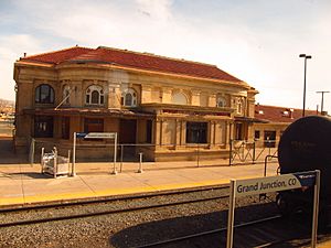
For train travel, Union Pacific provides freight service. Amtrak, the national passenger train system, has service to the Grand Junction Station. Its California Zephyr train runs daily between Chicago and Emeryville, California (near San Francisco).
Bus and Local Transit
Bustang, Colorado's state-run bus system, offers bus service between cities. Two bus lines include Grand Junction. The West line goes to Denver, and the Outrider line goes to Durango. Both lines have many stops.
Grand Valley Transit (GVT) is the local bus system for the Grand Valley. It has 11 bus routes and a "dial-a-ride" service.
The city also has a shared e-scooter program that started in May 2023. Companies like Bird and Lime rent out e-scooters through their apps.
Trails and Pathways
Grand Junction has a growing network of trails for walking and biking. The riverfront trail system runs along the Colorado River. It goes from Loma to Palisade, though some parts are still being built. The monument trail connects the riverfront trail and downtown to the Lunch Loops biking area. In 2023, the city council approved a plan to improve walking and biking paths. The city also received a silver award from the League of American Bicyclists in 2024.
Major Highways
 Interstate 70 runs across the country from Utah to Maryland. It connects Grand Junction to Denver, Kansas City, St. Louis, and other major cities. It also links to Las Vegas, Nevada, and southern California.
 U.S. Highway 6 goes east–west through 14 states. In Colorado, it generally runs next to Interstate 76 and Interstate 70.
 U.S. Highway 50 crosses 12 states, from Maryland to California. In Colorado, it connects Grand Junction with Montrose, Gunnison, and Pueblo. To the west, it goes into Utah.
 SH 340 runs east–west. It starts in downtown Grand Junction and goes through the Redlands. It ends where U.S. Highway 6 and U.S. Highway 50 meet in Fruita.
Notable People
Many interesting people have connections to Grand Junction:
- Owen Aspinall, a former governor of American Samoa
- Sabré Cook, a racing driver
- Ross Davis, another racing driver
- Charles L. Fletcher, an architect and interior designer
- Ben Garland, an NFL football player
- Chuck Hull, an inventor
- Jeff Hurd, a U.S. representative
- Vance Johnson, a former NFL wide receiver
- Aryn Kyle, an author
- Kathryn Mientka, a pianist
- Tyme Mientka, a cellist
- Annabelle Craft Moss, an aviator who served in World War II
- Bill Musgrave, a former NFL player and coach
- Rick Schroder, an actor and film director
- Elmo Smith, a former governor of Oregon
- Michael Strobl, a U.S. Marine, known from the film Taking Chance
- Dalton Trumbo, a screenwriter
- Walter Walker, a political leader and publisher
- Dean Withers, a live streamer and political commentator
Sister City
Grand Junction has one sister city, which helps build friendships between different places:
 El Espino (Jucuarán), Usulután Department, El Salvador
See also
 In Spanish: Grand Junction (Colorado) para niños
 | Aurelia Browder |
 | Nannie Helen Burroughs |
 | Michelle Alexander |


