Emeryville, California facts for kids
Quick facts for kids
Emeryville, California
|
|||
|---|---|---|---|
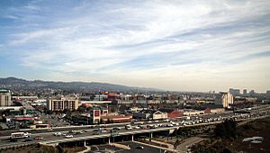
Emeryville as seen from a local highrise hotel
|
|||
|
|||
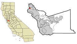
Location of Emeryville in Alameda County, California
|
|||
| Country | |||
| State | |||
| County | Alameda County | ||
| Incorporated | December 8, 1896 | ||
| Area | |||
| • Total | 2.25 sq mi (5.8 km2) | ||
| • Land | 1.28 sq mi (3.3 km2) | ||
| • Water | 0.97 sq mi (2.5 km2) 38.02% | ||
| Elevation | 23 ft (7 m) | ||
| Population
(2020)
|
|||
| • Total | 12,905 | ||
| • Density | 10,082.03/sq mi (3,892.69/km2) | ||
| Time zone | UTC-8 (Pacific Standard Time Zone) | ||
| • Summer (DST) | UTC-7 (Pacific Daylight Time) | ||
| ZIP code |
94608
|
||
| Area code(s) | 510, 341 | ||
| FIPS code | 06-22594 | ||
| GNIS feature IDs | 1658499, 2410436 | ||
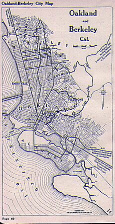
Emeryville is a city in Alameda County, California, in the United States. It is located between the cities of Berkeley and Oakland. The city also borders the beautiful San Francisco Bay.
In 2020, about 12,905 people lived there. Emeryville is close to San Francisco, the Bay Bridge, the University of California, Berkeley, and Silicon Valley. This location has helped the city's economy grow a lot recently.
Many famous companies have their homes in Emeryville. These include Pixar Animation Studios, Peet's Coffee, and Clif Bar. Other well-known tech and software companies like LeapFrog and Novartis (which used to be Chiron) are also there. Many people travel to Emeryville for work because it is a major job center in the region.
Emeryville is an important urban area, even though it is part of the larger Oakland and East Bay region. It became an industrial city before the First World War.
Contents
History of Emeryville
Early Beginnings
Long before European settlers arrived, the area where Emeryville is now was home to Native American communities. The historic Ohlone people lived here. They used the rich resources of the bay, gathering clams and oysters, catching fish, and hunting. Women also collected acorns from oak trees, roots, and fruits.
The Ohlone left behind huge piles of clam and oyster shells. These piles are now known as the Emeryville Shellmound.
During the Spanish and Mexican times, a small dock was built near Temescal Creek. This dock was used by the Peralta family's Rancho San Antonio. They loaded cattle hides, which were a main product, onto smaller boats. These boats then took the hides to larger ships, including those sailing to New England.
Cattle remained important even after the American era began. Many meat packing plants were built along the bay in Emeryville. This area was called "Butchertown." The cattle were brought in by train or boat from nearby ranches. The smells from these plants were very strong and often mentioned in old newspapers.
Emeryville got its first post office in 1884. The town officially became a city on December 2, 1896. It was named after Joseph Stickney Emery. He came to California during the California Gold Rush and bought a lot of land in the area.
Growth in the 20th Century
In the early 1900s, a local transportation company called the Key System grew in Emeryville. They built a long pier into San Francisco Bay. The Key System also had its main train yard near the Santa Fe Railway yard. The Key System's power plant, which powered its electric streetcars, was a famous landmark. Its tall smokestack was damaged in the Loma Prieta earthquake in 1989 and later taken down.
The old Key System train line to the pier ran in a subway under Beach Street. This subway still exists today. It is used as a private entrance to the main sewage treatment plant for the area.
In the late 1980s and early 1990s, the old train yards were redeveloped. This area became a large shopping center and residential neighborhood.
Emeryville also had a large park around the shellmound. It included dance halls and the Oakland Trotting Park for horse racing. In 1920, the first greyhound racing track in the world to use a mechanical rabbit opened in Emeryville.
The city was also home to Oaks Park, where the Oakland Oaks baseball team played. Today, part of this site is where Pixar Animation Studios is located.
During World War II, Emeryville was a key stop for the Shipyard Railway. This special electric train line took defense workers to the Kaiser Shipyards in Richmond.
Industrial Changes and Modern Development
From the late 1800s to the early 1900s, Emeryville continued to grow as an industrial city. Besides meat-packing plants, there was the Judson Iron Works and the Sherwin-Williams paint company. For many years, the Sherwin-Williams plant had a huge neon sign on its roof. It showed a can of red paint spilling over a globe with the slogan "Cover the Earth." Drivers on the Bay Bridge could easily see it.
The research part of Shell Oil Company, Shell Development, was also in Emeryville until 1972. A large scrap metal yard and its "Judson Steel" sign were visible from the freeway for decades. A factory that made heavy trucks, formerly part of International Harvester, was also in Emeryville. One of their popular truck models was even nicknamed an "Emeryville."
By the late 1960s, many industries started leaving Emeryville. This led to a decline in jobs and the city. However, things began to change in the mid-1970s with the development of the marina area. The Judson steel mill closed in 1986 after over 100 years.
In the late 1980s, a large shopping area began to grow. The Chiron Corporation (now Novartis), a big biotechnology company, also set up its main office here.
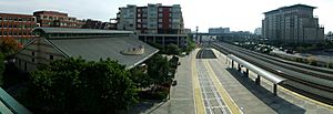
After the Loma Prieta earthquake in 1989, a new Amtrak train station was built in Emeryville. It replaced the old station in West Oakland, which was damaged by the earthquake. The Emeryville station is a major stop for trains like the California Zephyr and Coast Starlight. Buses connect the station to San Francisco.
In the late 1980s, the Emeryville Public Market opened. This market has a farmers' market and many restaurants.
By the 1990s, the old train yards were turned into a large shopping and living area. This included building new roads and an overpass over the railroad tracks. In 2001, the Bay Street Shopping Center was built. This site was once an Ohlone village and burial ground. Developers worked with archaeologists and Ohlone representatives to protect the remains. The mall now shows photos of the historic shellmound.
Geography and Environment
Emeryville covers about 2.0 square miles (5.2 km²). About 1.2 square miles (3.1 km²) is land, and 0.8 square miles (2.1 km²) is water. The Watergate area in Emeryville has a marina, a park, homes, and offices.
Mudflats and Nature
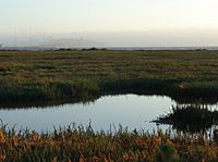
The Emeryville Mudflats were once known for their strong smell. In the past, waste from the meat-packing plants and untreated sewage from nearby cities flowed into the bay here. This caused a bad odor, especially on warm days. In the 1950s, a regional sewage treatment plant was built. This greatly reduced the smell.
In the 1960s and 1970s, the mudflats became famous for public art. Artists and students used driftwood and boards to create sculptures. These artworks were admired by drivers on the Bay Bridge. The mudflats even appeared in the 1971 movie Harold and Maude.
In the late 1990s, these sculptures were removed. This was done to help create a more natural marshland for wildlife. This effort to restore wetlands is happening in many places around the bay.
Historically, Emeryville had many heavy industries. Their properties were built on waste and construction debris. Because of this, much of the soil contained harmful substances. A lot of this contamination was removed in the 1980s when the city was redeveloped.
Climate
Emeryville has a Mediterranean climate. This means it has mild, wet winters and warm, dry summers, similar to nearby Oakland.
Population Data
| Historical population | |||
|---|---|---|---|
| Census | Pop. | %± | |
| 1890 | 228 | — | |
| 1900 | 1,016 | 345.6% | |
| 1910 | 2,613 | 157.2% | |
| 1920 | 2,390 | −8.5% | |
| 1930 | 2,336 | −2.3% | |
| 1940 | 2,521 | 7.9% | |
| 1950 | 2,889 | 14.6% | |
| 1960 | 2,686 | −7.0% | |
| 1970 | 2,681 | −0.2% | |
| 1980 | 3,714 | 38.5% | |
| 1990 | 5,740 | 54.6% | |
| 2000 | 6,882 | 19.9% | |
| 2010 | 10,080 | 46.5% | |
| 2020 | 12,905 | 28.0% | |
| 2024 (est.) | 13,314 | 32.1% | |
| U.S. Decennial Census | |||
2010 Census
In 2010, Emeryville had a population of 10,080 people. The city had about 8,090 people per square mile.
- About 44.5% of the people were White.
- About 17.5% were Black.
- About 27.5% were Asian.
- About 9.2% were Hispanic or Latino.
There were 5,694 households. About 12.2% of these households had children under 18. The average household had 1.76 people. The average family size was 2.61 people.
The population was spread out by age:
- 10.2% were under 18.
- 46.4% were between 25 and 44.
- 10.0% were 65 or older.
The average age in Emeryville was 35.0 years.
Schools in Emeryville
The Emery Unified School District serves students in Emeryville and parts of Oakland. Its schools are Anna Yates Elementary School and Emery Secondary School. Both schools are on the same campus.
The East Bay German International School (EBGIS) is a German language immersion school. It opened in Emeryville in 2017.
Ex'pression College for Digital Arts was a private college in Emeryville from 1993 until it closed in 2022.
Economy and Businesses
As of July 1, 2019, businesses in Emeryville must pay employees at least $16.30 per hour. Many companies have their main offices in the city. Some of these include:
- Adobe Systems: A big software company.
- Alternative Tentacles: An independent record label known for punk music.
- Amyris: A biotech company focused on sustainable products.
- Bayer: A biotech company that researches and makes medicines.
- Clif Bar: A company that makes natural food products.
- Electronic Arts: One of the world's largest video game makers.
- Grocery Outlet: A discount supermarket chain.
- LeapFrog: An educational toy company famous for its LeapPad.
- Peet's Coffee: A well-known coffee roaster and seller.
- Pixar Animation Studios: A major animation and computer graphics company known for award-winning movies. The Walt Disney Company bought Pixar in 2006.
Shopping Areas
Emeryville has several shopping centers near the Interstate 80 and 580 highways. These centers take advantage of Emeryville's easy access for customers from San Francisco and the East Bay. A new shopping and living area called Bay Street Emeryville has many stores and restaurants.
Major Employers
Here are some of the top employers in Emeryville, based on a 2022 report:
| # | Employer | # of Employees |
|---|---|---|
| 1 | Pixar | 1,465 |
| 2 | Amyris | 595 |
| 3 | AC Transit | 435 |
| 4 | Grocery Outlet Headquarters | 427 |
| 5 | Clif Bar | 343 |
| 6 | Grifols | 265 |
| 6 | IKEA | 265 |
| 8 | Peet's Coffee | 255 |
| 9 | Oaks Card Club | 217 |
| 10 | City of Emeryville | 170 |
Transportation
The Emeryville Amtrak station was finished in 1994. It serves four major train lines:
- California Zephyr: Travels daily to Chicago, Illinois.
- Capitol Corridor: A commuter train between San Jose and Auburn.
- Coast Starlight: Travels between Seattle and Los Angeles.
- San Joaquins: Travels between Sacramento and Bakersfield.
Emeryville is the main station in the San Francisco Bay Area for the two long-distance train lines. About 500,000 passengers use it each year. Amtrak does not have direct train service to San Francisco. Passengers going to San Francisco use a bus that connects to the Emeryville station.
The Bay Area Rapid Transit (BART) system connects San Francisco, Oakland, and San Jose. The closest BART station is MacArthur station in Oakland, about 2 miles (3.2 km) east of the Amtrak station.
Public bus service in Emeryville is provided by AC Transit. The city also runs a free shuttle service called Emery Go Round. It runs every 15 minutes on weekdays. It connects to the MacArthur BART station, the Amtrak station, shopping areas, and other places in Emeryville and Berkeley.
Major highways like Interstate 80, Interstate 880, and Interstate 580 provide easy access to Emeryville. These highways meet at a large interchange called the MacArthur Maze.
Emeryville also has a small marina for boats. There is a special committee of citizens that advises on bicycle and pedestrian issues.
Notable People
Some famous people who live or have lived in Emeryville include:
- Draymond Green: An NBA basketball player.
- Dianne Martinez: The first Filipino American city council member and mayor.
- Kofi S. Bonner: An architect.
Images for kids
See also
 In Spanish: Emeryville para niños
 | Precious Adams |
 | Lauren Anderson |
 | Janet Collins |


